Beverley Squares

Last updated
Argyle Road, Beverly Square West Argyle Rd Beverley Sq West jeh.jpg
Argyle Road, Beverly Square West
East 16th Street, Beverly Square East E16 St Beverley Sq East jeh.jpg
East 16th Street, Beverly Square East

Beverley Square East and Beverley Square West, also spelled Beverly Square, are a pair of neighborhoods in the Flatbush section of the New York City borough of Brooklyn. Located southwest of Prospect Park within what is now called Victorian Flatbush, one of the largest concentrations of Victorian houses in the United States, they were developed in the 1900s primarily by Thomas Benton Ackerson, whose former home is in Beverley Square West.

Contents

Context and construction

The two neighborhoods extend from Beverley Road in the north (south of Prospect Park South) to Cortelyou Road in the south. The cut for the BMT Brighton Line of the New York City Subway between Marlborough Road (East 15th Street) and East 16th Street forms the boundary between them: Beverley Square East extends east from there to East 19th Street, and Beverley Square West west from there to Stratford or Argyle Road. [1] [2] Four of the five north-south streets in the development were renamed for a British high tone. [3] The Beverley Squares, like most of Victorian Flatbush, were built on rural land. [4] Ackerson organized his development company in order to develop Beverley Square East, [4] [5] [6] beginning work in 1898 with a line of large houses along East 19th Street. [2] Beverley Square West was built on Catherine Lott's farm, [7] which Ackerson acquired in 1901. [8]

Ackerson arranged for there to be subway stations on the new Brooklyn Rapid Transit line at both the north and the south ends of the two neighborhoods, only a block apart, the two closest open stations in the New York City Subway system: Beverley Road and Cortelyou Road on the BMT Brighton Line (now the local Q service). [1] [2] The line was also placed in the cut in response to developer pressure; it was originally at grade level. [5] [7]

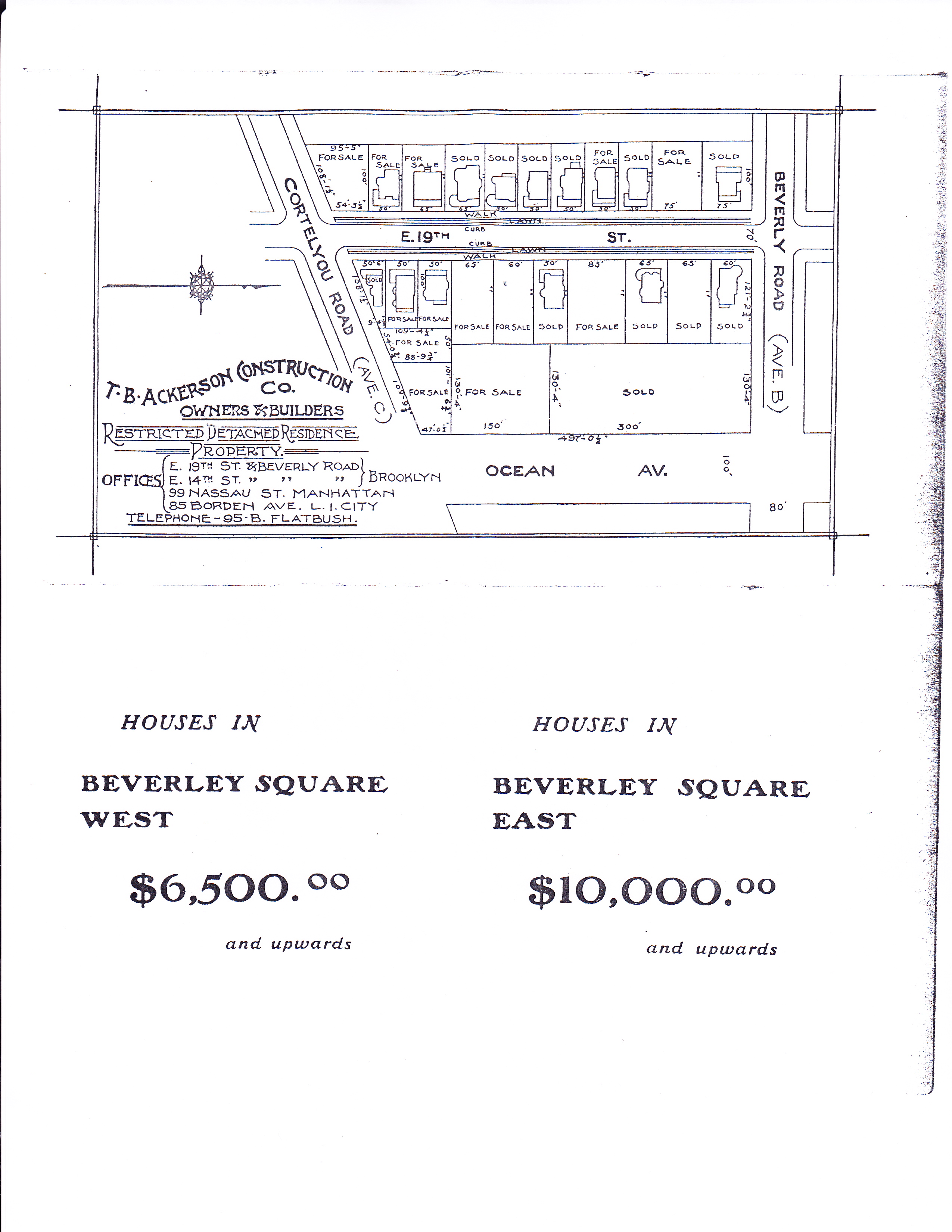
Originally Ackerson offered his houses in Beverley Square East for sale at $10,000 and up, and those in Beverley Square West at $6,500 and up; [9] when sales of the first houses in Beverley Square East were disappointing, he had the rest of that neighborhood developed with somewhat simpler houses by Lewis H. Pounds and Delbert H. Decker (it was completed in 1901), and modified his plan for Beverley Square West, building somewhat smaller and less distinctive houses. [1] [10] The Beverley Squares were "Ackerson's major project"; [3] his own home was in Beverley Square West, at 304 Marlborough Street (built in 1903), and Pounds, who later served as Brooklyn Borough President, had his home at 317 East 17th Street in Beverley Square East. [1] Beverley Square West also includes the "honeymoon cottage" built as a wedding present for a daughter of the Guggenheim family, at 305 Rugby Road. [11]

Gentrification

Like the rest of Victorian Flatbush, the Beverley Squares have been revitalized since the 1970s by an influx of new residents who value the relatively cheap houses in a variety of architectural styles with details such as fluted columns, stained glass, large porches, and turrets. Beverley Square West has an active residents' association that celebrated the centenary of the neighborhood in 2002 and is trying to achieve designation by the New York City Landmarks Preservation Commission, [1] [3] but without success as of 2010. [12] Together with Ditmas Park West, the Beverley Squares are now often thought of as part of Ditmas Park. [13] [14]

Education

Public School 139, the Alexine Fenty School, [15] occupies the blockfront of Cortelyou Road between Rugby and Argyle Roads in Beverley Square West; several of the original houses were demolished to build an extension to the school. [1] The "mini-school" annex opened in 1989. [16]

Related Research Articles

<span class="mw-page-title-main">Q (New York City Subway service)</span> New York City Subway service

The Q Second Avenue/Broadway Express/Brighton Local is a rapid transit service in the B Division of the New York City Subway. Its route emblem, or "bullet", is colored yellow since it uses the BMT Broadway Line in Manhattan.

The BMT Brighton Line, also known as the Brighton Beach Line, is a rapid transit line in the B Division of the New York City Subway in Brooklyn, New York City, United States. Local service is provided at all times by the Q train, but is joined by the B express train on weekdays. The Q train runs the length of the entire line from Coney Island–Stillwell Avenue to the Manhattan Bridge south tracks. The B begins at Brighton Beach and runs via the bridge's north tracks.

<span class="mw-page-title-main">Flatbush, Brooklyn</span> Neighborhood of Brooklyn in New York City

Flatbush is a neighborhood in the New York City borough of Brooklyn. The neighborhood consists of several subsections in central Brooklyn and is generally bounded by Prospect Park to the north, East Flatbush to the east, Midwood to the south, and Kensington and Parkville to the west. The neighborhood had a population of 105,804 as of the 2010 United States Census. The modern neighborhood includes or borders several institutions of note, including Brooklyn College.

Fiske Terrace is a planned community and neighborhood in the New York City borough of Brooklyn. Fiske Terrace is located in south central Brooklyn in the southern edge of the community of Flatbush and north of the community of Midwood. It is bounded by Glenwood Road on the north, Ocean Avenue on the east, the Bay Ridge Branch of the Long Island Rail Road/New York and Atlantic Railway right-of-way on the south, and the New York City Subway BMT Brighton Line subway line on the west.

<span class="mw-page-title-main">Prospect Park South</span> United States historic place

Prospect Park South is a small neighborhood in Flatbush, Brooklyn, New York City, located south of Prospect Park. It is included within the Prospect Park South Historic District, which was designated by the New York City Landmarks Preservation Commission in 1979 and listed on the National Register of Historic Places in 1983. The historic district is bounded by Church Avenue to the north, the BMT Brighton Line of the New York City Subway to the east, Beverley Road to the south, and between Stratford Road and Coney Island Avenue to the west.

<span class="mw-page-title-main">T. B. Ackerson Company</span>

T.B. Ackerson Company was a real estate development company that built several planned communities in the New York metropolitan area during the late 19th and early 20th Centuries.

<span class="mw-page-title-main">Flatbush Avenue</span> Avenue in Brooklyn, New York

Flatbush Avenue is a major avenue in the New York City Borough of Brooklyn. It runs from the Manhattan Bridge south-southeastward to Jamaica Bay, where it joins the Marine Parkway–Gil Hodges Memorial Bridge, which connects Brooklyn to the Rockaway Peninsula in Queens. The north end was extended from Fulton Street to the Manhattan Bridge as "Flatbush Avenue Extension".

<span class="mw-page-title-main">Prospect Park station (BMT lines)</span> New York City Subway station in Brooklyn

The Prospect Park station is an express station on the BMT Brighton Line of the New York City Subway. Located in between Lincoln Road, Lefferts Avenue, Empire Boulevard, Ocean Avenue and Flatbush Avenue in Flatbush, Brooklyn, near the border of Crown Heights, Prospect Heights, Park Slope, and Prospect Lefferts Gardens, it is served by the Q train and Franklin Avenue Shuttle at all times and by the B train on weekdays.

<span class="mw-page-title-main">Ditmas Park, Brooklyn</span> United States historic place

Ditmas Park is a historic district in the neighborhood of Flatbush in Brooklyn, New York City. The traditional boundaries of Ditmas Park, including Ditmas Park West, are Ocean Avenue and greater Flatbush to the east, Dorchester Road and the Prospect Park South neighborhood to the north, Coney Island Avenue and the Kensington neighborhood to the west, and Newkirk Avenue to the south. The name Ditmas Park is often used a shorthand for the several neighborhoods that comprise the larger area of Victorian Flatbush.

<span class="mw-page-title-main">Seventh Avenue station (BMT Brighton Line)</span> New York City Subway station in Brooklyn

The Seventh Avenue station is a station on the BMT Brighton Line of the New York City Subway, located at the intersection of Seventh Avenue, Park Place and Flatbush Avenue in Park Slope and Prospect Heights, Brooklyn. The station is served by the Q train at all times and by the B train on weekdays only.

<span class="mw-page-title-main">Avenue H station</span> New York City Subway station in Brooklyn

The Avenue H station is a local station on the BMT Brighton Line of the New York City Subway. It is located at Avenue H between East 15th and East 16th Streets near the border of Midwood and Flatbush, Brooklyn. The station is served by the Q train at all times.

<span class="mw-page-title-main">Newkirk Plaza station</span> New York City Subway station in Brooklyn

The Newkirk Plaza station is an express station on the BMT Brighton Line of the New York City Subway in Flatbush, Brooklyn. It is located on an open-cut at the center of the pedestrian-only Newkirk Plaza shopping mall, which is bounded by Newkirk Avenue on the north, Foster Avenue on the south, Marlborough Road to the west, and East 16th Street to the east. The station is served by the Q train at all times and by the B train on weekdays only.

<span class="mw-page-title-main">Beverley Road station</span> New York City Subway station in Brooklyn

The Beverley Road station is a local station on the BMT Brighton Line of the New York City Subway. It is located over a private right-of-way at Beverly Road between Marlborough Road/East 15th Street and East 16th Street in the neighborhood of Flatbush, Brooklyn. The station is served by the Q train at all times.

<span class="mw-page-title-main">Cortelyou Road station</span> New York City Subway station in Brooklyn

The Cortelyou Road station is a local station on the BMT Brighton Line of the New York City Subway, located at Cortelyou Road between Marlborough Road and East 16th Street in the neighborhood of Flatbush, Brooklyn. The station is served by the Q train at all times.

<span class="mw-page-title-main">Ditmas Avenue station</span> New York City Subway station in Brooklyn

The Ditmas Avenue station is a local station on the IND Culver Line of the New York City Subway. Located at the intersection of Ditmas and McDonald Avenues in Kensington, Brooklyn, it is served by the F train at all times and the <F> train during rush hours in the peak direction.

<span class="mw-page-title-main">Victorian Flatbush</span> Neighborhood of Brooklyn in New York City

Victorian Flatbush is the western section of the Flatbush section of Brooklyn, New York, bordering Midwood, that is characterized by Victorian houses.

<span class="mw-page-title-main">West Midwood, Brooklyn</span> Neighborhood of Brooklyn in New York City

West Midwood is a planned community and historic enclave in the New York City borough of Brooklyn. West Midwood is located in central Brooklyn in the southern edge of the community of Victorian Flatbush, abutting the northern boundary of the community of Midwood. It is bordered by Foster Avenue to the north, the BMT Brighton subway line to the east, Avenue H to the south, and Coney Island Avenue to the west. West Midwood is located south of Prospect Park within what is sometimes referred to as Ditmas Park.

References

  1. 1 2 3 4 5 6 Nedda C. Allbray, Flatbush: The Heart of Brooklyn, Making of America, Charleston, South Carolina: Arcadia, 2004, ISBN   9780738524535, pp. 142–43.
  2. 1 2 3 Beverly Square East and West Neighborhood Associations, Brooklyn Community Board 14, retrieved January 20, 2013.
  3. 1 2 3 Evan Lerner, "Peaked Roofs, Crossed Fingers", The City, The New York Times , March 16, 2008.
  4. 1 2 Peter Ross, A History of Long Island: From Its Earliest Settlement to the Present Time, Volume 3 by William S. Pelletreau, OCLC   24140988, New York: Lewis, 1905, p. 403.
  5. 1 2 Metropolis 2 (1982) p. 23.
  6. Herbert F. Gunnison, Flatbush of Today 2.1, April 1908, OCLC   11367764, p. 100.
  7. 1 2 The Early Years, Victorian Flatbush, retrieved January 21, 2013.
  8. Gunnison, pp. 100–01.
  9. T. B. Ackerson Company sales brochure for Beverley Square West and Beverley Square East, p. 6, online at Beverley Square West Association.
  10. Gunnison, p. 101.
  11. Adrienne Onofri, Walking Brooklyn: 30 Tours Exploring Historical Legacies, Neighborhood Culture, Side Streets and Waterways, Berkeley, California: Wilderness, 2007, ISBN   9780899975580, p. 104.
  12. Jen Carlson, "The LPC Called Out For Playing Favorites" Archived 2010-03-13 at the Wayback Machine , Gothamist, March 10, 2010.
  13. John Rather, "If You're Thinking of Living In/Ditmas Park, Brooklyn; A Suburban Enclave in an Urban Setting", Real Estate, The New York Times, July 5, 1998.
  14. Jake Mooney, "Moved for the Space; Stayed for the Food", Living In | Ditmas Park, Brooklyn, Real Estate, The New York Times, November 13, 2009.
  15. Rosalie R. Radomsky, "If You're Thinking of Living In/Prospect Park South; A Turn-of-the-Century Brooklyn 'Suburb'", Real Estate, The New York Times, January 1, 1995, p. 2.
  16. Eve M. Kahn, "A Lesson in Playfulness: School Annexes That Please the Eye", The New York Times, October 19, 1989.

Coordinates: 40°38′30″N73°57′54″W / 40.64167°N 73.96500°W / 40.64167; -73.96500