
Solapur is a city located in the south-western region of the Indian state of Maharashtra, close to its border with Karnataka. Solapur is located on major highway, rail routes between Mumbai, Pune, Bangalore and Hyderabad, with a branch line to the cities of Kalaburagi and Vijayapura in the neighbouring state of Karnataka. Solapur International Airport is under construction. It is classified as A1 Tier and B-1 class city by House Rent Allowance (HRA) classification by the Government of India. It is the seventh biggest Metropolis Urban Agglomeration and 11th most populated city in Maharashtra as well as 43rd largest urban agglomeration and 49th most populous city in India.

Osmanabad District, officially known as Dharashiv District, is an administrative district in the Marathwada region in the Indian state of Maharashtra. The district headquarter is located at Osmanabad. The District of Osmanabad derives its name from the last ruler of Hyderabad, the 7th Nizam, Mir Osman Ali Khan, of which the region was a part till 1947. This region was earlier part of The Hyderabad State until Independence.This primarily rural district occupies an area of 7,569 km2 (2,922 sq mi) of which 241.4 km2 (93.2 sq mi) is urban and has a population of 1,657,576 of which 16.96% were urban.
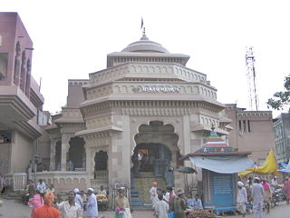
Pandharpur is a Popular pilgrimage town, on the banks of Chandrabhagā River, near Solapur city in Solapur District, Maharashtra, India. Its administrative area is one of eleven tehsils in the District, and it is an electoral constituency of the state legislative assembly. The Vithoba temple attracts about a million Hindu pilgrims during the major yātrā (pilgrimage) in Ashadha (June–July).
Malshiras is a town and the headquarters of Malshiras taluka in Solapur district of Maharashtra state in western India. Its governing body is promoted to Nagar Panchayat from a Gram Panchayat in 2017. There are many popular towns in Malshiras taluka such as Akluj, Natepute, Mahalung, Malinagar, Velapur and popular Villages like Rajapur (Islampur) Goradwadi, Bhamburdi, Medad and Palasmandal. Rajapur (Islampur) is adjacent to Malshiras which has good literacy rate and having historic samadhi mandir of Veer Santaji Ghorpade.

Osmanabad, officially known as Dharashiv, is a city and a municipal council in Osmanabad district in the Indian state of Maharashtra. The city is the administrative headquarter of Osmanabad district. It is the seventh largest city in Marathwada, and the 39th largest city in Maharashtra by population.
Akkalkot is a city and a municipal council in Solapur district in the Indian state of Maharashtra. It is situated 38 km southeast of Solapur and close to the border of Karnataka state.

Solapur District is a district in Maharashtra state of India. The city of Solapur is the district headquarters. It is located on the south east edge of the state and lies entirely in the Bhima and Seena basins. The entire district is drained by the Bhima River.
Tuljapur is a town with a municipal council in Dharashiv district in the Indian state of Maharashtra. It is the administrative seat of Tuljapur taluka.
Chikhli is a city and a municipal council in Buldana district in Vidarbha Region of Maharashtra state, India. It is located on the Pune-Nagpur highway. It is situated at the westernmost border of Vidarbha region of Maharashtra and is 500 km from the state capital, Mumbai. Chikhli is situated on the border of the Marathwada Region and Vidarbha Regions of Maharashtra.
Kurduvadi is Big Railway Junction in Solapur district in Maharashtra state of India. It is situated on Barshi Light Railway It is known mainly for the railway junction connecting two different rail tracks. Prior to gauge conversion it used to be a junction with different size gauge tracks.
Vairag is a town in Barshi Taluka of Solapur district in Maharashtra, India. The village is located centrally between Solapur and Barshi.
Chadchan is a taluq in the southern state of Karnataka, India. It is located in Vijayapura district in northern part of Karnataka.

Daund taluka is a taluka or subdivision of Pune district of the state of Maharashtra in India. The town of Daund is the only major urban area in this predominantly rural area. Daund railway station is a major railway junction. All southern railways are connected to this route, and also divided the Nagar railway to north Indian railway, like Delhi, Solapur division, Daund junction and then joined to the Pune district junction. To reach the Siddhi Vinayak Siddhatek Ganpati temple, one has to travel 14 km to Daund by road.
Umarga (Omerga) Tehsil is a tehsil/ taluka/ subdistrict in Osmanabad district, Maharashtra on the Deccan Plateau of India. The town of Umarga is the administrative headquarters of the tehsil. There are 79 panchayat villages in Umarga Tehsil.
Alur is a panchayat village in the state of Maharashtra, India. It is administratively under the Umarga Tahsil of Osmanabad District in Maharashtra. There is only the single village of Alur in the Alur gram panchayat. The village is 31 km by road southeast of Naldurg and 52 km by road southwest of Umarga, but only 13 km by road northeast of Wagdari, in Solapur District.
Shetphal is a village in the Mohol taluka of Solapur district in Maharashtra state, India. According to Census 2011 information, the location code or village code of Shetphal village is 562192. It is situated 24km away from sub-district headquarter Mohol and 69km away from district headquarter Solapur. As per 2009 stats, Shetphal village is also a gram panchayat. The total geographical area of village is 3089 hectares. Kurduvadi is nearest town to shetphal for all major economic activities, which is approximately 22km away.
Hingani is a village in the Karmala taluka of Solapur district in Maharashtra state, India.
Chikhalthan is a village in the Kannad taluka of Aurangabad district in Maharashtra State, India.
Yenegur is a major village located in Omerga tehsil of Osmanabad district, which is part of the Marathwada region of the state of Maharashtra in India.
Kumbhari is a village in Solapur district, Maharashtra, India. It lies on the suburbs of Solapur, about 12 kilometres east of the city center. As per the 2011 census, the village had a population of 31,044.