Bhavadevarapalle | |
---|---|
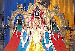
![]() Presiding deities of famous temple at Bhavadevarapalli | |
![]() Dynamic map | |
Coordinates: 16°06′50″N81°01′16″E / 16.114°N 81.021°E | |
Country | India |
State | Andhra Pradesh |
District | Krishna |
Founded by | Bhogadi's |
Area | |
• Total | 24.28 km2 (9.37 sq mi) |
Population (2011) [2] | |
• Total | 3,061 |
• Density | 130/km2 (330/sq mi) |
Languages | |
• Official | Telugu |
Time zone | UTC+5:30 (IST) |
PIN | 521120 |
Telephone code | 91-8671 |
Vehicle registration | AP |
Bhavadevarapalle, also Bhavadevarapalli, [3] is a village in Krishna district of Indian state of Andhra Pradesh. It is located in Nagayalanka mandal of Machilipatnam revenue division. It is known for the famous Bhavannarayana Temple. Because of this temple the village got its name. [1] It is located 5 kilometres (3.1 mi) southwest of another famous temple at Lingareddypalem.
Krishna district is a district in the coastal Andhra Region in Indian state of Andhra Pradesh, with Machilipatnam as its administrative headquarters. It is surrounded on the East by Bay of Bengal, West by Guntur, Bapatla and North by Eluru and NTR districts and South again by Bay of Bengal.
Nathdwara is a city in the Rajsamand district of the state of Rajasthan, India. It is located in the Aravalli hills, on the banks of the Banas River and is 48 kilometres north-east of Udaipur. Shrinathji, is a swarup of lord Krishna which resembles his 7-year-old "infant" incarnation of Krishna. The deity was originally worshiped at Jatpura, Mathura and was shifted in the year 1672 from Govardhan hill, near Mathura along holy river Yamuna after being retained at Agra for almost six months. Literally, Nathdwara means 'Gateway to Shrinathji (God)'. Nathdwara is a significant Vaishnavite shrine pertaining to the Pushti Marg or the Vallabh Sampradaya or the Shuddha Advaita founded by Vallabha Acharya, revered mainly by people of Gujarat and Rajasthan, among others. Vitthal Nathji, son of Vallabhacharya institutionalised the worship of Shrinathji at Nathdwara. Today also the Royal king family of Nathdwara belongs to the lineage of vallabhacharya mahaprabhuji. They are called Tilkayat or tikaet of Nathdwara.
Sangli district is a district of Maharashtra state in India. Sangli city is the district headquarters. It is bordered by Satara district, Solapur district to the North, Karnataka state to the South-East, by Kolhapur district to South-West and by narrow portion on the East side to Ratnagiri district. It is present on the southern tip of Maharashtra.
Baldeo is a town and a nagar panchayat in Mathura district in the state of Uttar Pradesh, India.
Chavakkad, formerly Chowghat, is a municipality in the Thrissur district of the Indian state of Kerala. Chavakkad is noted for its beach and fishing. It lies on National Highway 66 is located about 75 km (47 mi) north of the city of Kochi, 25 km (16 mi) northwest of Thrissur, and 24 km (15 mi) south of Ponnani.
Chikkodi is a taluka and Town Municipal Council in the Belagavi district of Karnataka, India. It is a Subdivision of the district. Chikodi, Athani, Hukkeri, Raybag, Nipani and Kagwad are the taluks that come under Chikodi Subdivision. It is 75 kilometers from the city of Belgaum, 65 kilometers from Kolhapur, 51 kilometers from Miraj, 160 kilometers from Hubballi, and 570 kilometers from the capital of Karnataka state, Bengaluru. Chikodi has many district level offices but it is not designated as a district by the Government of Karnataka. It is one of the major cities that lies in the border between Karnataka and Maharashtra states.official language is Kannada.
Musafirkhana is a town and tehsil in Amethi district in Indian state of Uttar Pradesh. The word "Musafirkhana" means "Sarai," or "Dharamshala". Musafirkhana is located 32 km northwest of district headquarters Amethi.
Vuyyuru is a town in Krishna district of the Indian state of Andhra Pradesh. It is a Nagar panchayat and the headquarters of Vuyyuru Mandal. It is emerging as neighbourhood of Vijayawada, India situated 30 km away.
Kulanada is a village in Pandalam, that is located in the district of Pathanamthitta bordering with Alappuzha district in Kerala state within India. Kulanada assumed its name from the combination of words "Kulam" and "Nada". Kulam meaning pond and Nada meaning the temple where the king of Pandalam worshiped.
Mopidevi is a village in Krishna district of the Indian state of Andhra Pradesh. It is the mandal headquarters of Mopidevi mandal in Machilipatnam revenue division. It is one of the villages in the mandal to be a part of Andhra Pradesh Capital Region. The village is known for its famous Lord Subrahmanyeswar Swamy Temple. The village is situated 80Km from Vijayawada and 30Km from Machilipatnam.
Palus is a city and municipal council in sangli district. Palus is developed city in Sangli district. City have best industrial zone, steel firms, foundries and Precision Machine shop.
Athani is a town in the Belagavi district of Karnataka, India. It is 140 kilometers from the city of Belagavi, 70 kilometers from Vijayapura, 55 kilometers from Miraj, 100 kilometers from Kolhapur, and 624 kilometers from Bengaluru.
Cherukunnu is a census town in Kannur district in the Indian state of Kerala. Cherukunnu town is located on Valapattanam-Pappinisseri-Pazhayangadi main road, situated to the south of the Pazhayangadi in Kannur District in Kerala.
Peringanadu is a small village in Pathanamthitta district, Kerala state, India. It is known by the presence of Peringanadu Trichenda Mangalam Mahadeva Temple.
Malayinkeezhu is a suburb of Trivandrum, the largest city and capital of the Indian state of Kerala. It is located at the south-eastern side of Thiruvananthapuram Metropolitan Area, and is at a distance of 13 km from the heart of the city. The town is famous for the religious festival named Malayinkeezhu Aarattu. Neyyar Wildlife Sanctuary, one of the major tourist destinations in Thiruvananthapuram district is situated 17 km away from the town. The nearest airport is Trivandrum International Airport (16 km) and Balaramapuram Railway Station (9.1 km) is the nearest Railway Station. The Pincode of Malayinkeezhu Post Office is 695571 which comes under the postal circle of Neyyattinkara region.
Nagaral(ನಾಗರಾಳ) is a village in the southern state of Karnataka, India. It is located in the Bilagi taluk of Bagalkot district in Karnataka. It is about 35 kilometres (22 mi) from the district headquarters of Bagalkot town and is about 5 kilometres (3.1 mi) from taluka headquarters of Bilagi and on the left bank of the Krishna River. It is famous for the Digamabareshwara temple and well educated persons.
Hirekudi is a village in the southern state of Karnataka, India. It is located in the Chikodi taluk of Belgaum district in Karnataka.
Hulagabali is a village in the southern state of Karnataka, India. It is located in the Athani taluk toward north-east of Belgaum district. The basic occupation in Hulagabali is agriculture and there are also many landlords in the village who are famous in agriculture. Sugarcane is the highest percentage of agriculture as per the survey. There are quite a few temples in the village. The Birappa temple located in this village is well known in surrounding villages. Birappa temple has a large fair and festivities twice a year that draws huge crowd in the region. Sri Sangameshwara temple stands at the juncture of River Krishna and River Agrani. The famous landlords are Patil and Gaddekars.
Konanur is a mid level town in the southern state of Karnataka, India. It is located in the Arkalgud taluk of Hassan district in Karnataka.
Manimangalam is a small town located in the Kanchipuram district of Tamil Nadu state in Southern India, famous for its ancient temples and inscriptions documenting the history of the ancient Tamil kings