Krucz is a village in the administrative district of Gmina Lubasz, within Czarnków-Trzcianka County, Greater Poland Voivodeship, in west-central Poland. It lies approximately 8 kilometres (5 mi) west of Lubasz, 12 km (7 mi) south-west of Czarnków, and 61 km (38 mi) north-west of the regional capital Poznań.
Górnica is a village in the administrative district of Gmina Trzcianka, within Czarnków-Trzcianka County, Greater Poland Voivodeship, in west-central Poland. It lies approximately 13 kilometres (8 mi) south-west of Trzcianka, 20 km (12 mi) north-west of Czarnków, and 77 km (48 mi) north-west of the regional capital Poznań.
Runowo is a village in the administrative district of Gmina Trzcianka, within Czarnków-Trzcianka County, Greater Poland Voivodeship, in west-central Poland. It lies approximately 10 kilometres (6 mi) south of Trzcianka, 12 km (7 mi) north-west of Czarnków, and 71 km (44 mi) north-west of the regional capital Poznań.
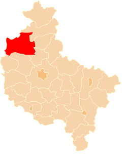
Dębogóra is a village in the administrative district of Gmina Wieleń, within Czarnków-Trzcianka County, Greater Poland Voivodeship, in west-central Poland. It lies approximately 10 kilometres (6 mi) north of Wieleń, 31 km (19 mi) west of Czarnków, and 84 km (52 mi) north-west of the regional capital Poznań.
Dzierżążno Małe is a village in the administrative district of Gmina Wieleń, within Czarnków-Trzcianka County, Greater Poland Voivodeship, in west-central Poland. It lies approximately 16 kilometres (10 mi) north of Wieleń, 27 km (17 mi) north-west of Czarnków, and 84 km (52 mi) north-west of the regional capital Poznań.
Dzierżążno Wielkie is a village in the administrative district of Gmina Wieleń, within Czarnków-Trzcianka County, Greater Poland Voivodeship, in west-central Poland. It lies approximately 11 kilometres (7 mi) north of Wieleń, 26 km (16 mi) west of Czarnków, and 81 km (50 mi) north-west of the regional capital Poznań.
Folsztyn is a village in the administrative district of Gmina Wieleń, within Czarnków-Trzcianka County, Greater Poland Voivodeship, in west-central Poland. It lies approximately 7 kilometres (4 mi) east of Wieleń, 21 km (13 mi) west of Czarnków, and 71 km (44 mi) north-west of the regional capital Poznań.
Gieczynek is a village in the administrative district of Gmina Wieleń, within Czarnków-Trzcianka County, Greater Poland Voivodeship, in west-central Poland. It lies approximately 13 kilometres (8 mi) north of Wieleń, 32 km (20 mi) west of Czarnków, and 85 km (53 mi) north-west of the regional capital Poznań.
Gulcz is a village in the administrative district of Gmina Wieleń, within Czarnków-Trzcianka County, Greater Poland Voivodeship, in west-central Poland. It lies approximately 15 kilometres (9 mi) east of Wieleń, 13 km (8 mi) west of Czarnków, and 65 km (40 mi) north-west of the regional capital Poznań.
Hamrzysko is a village in the administrative district of Gmina Wieleń, within Czarnków-Trzcianka County, Greater Poland Voivodeship, in west-central Poland. It lies approximately 15 kilometres (9 mi) south-east of Wieleń, 16 km (10 mi) south-west of Czarnków, and 61 km (38 mi) north-west of the regional capital Poznań.
Kocień Wielki is a village in the administrative district of Gmina Wieleń, within Czarnków-Trzcianka County, Greater Poland Voivodeship, in west-central Poland. It lies approximately 10 kilometres (6 mi) north-east of Wieleń, 23 km (14 mi) west of Czarnków, and 78 km (48 mi) north-west of the regional capital Poznań.
Kuźniczka is a village in the administrative district of Gmina Wieleń, within Czarnków-Trzcianka County, Greater Poland Voivodeship, in west-central Poland. It lies approximately 8 kilometres (5 mi) north-east of Wieleń, 24 km (15 mi) west of Czarnków, and 77 km (48 mi) north-west of the regional capital Poznań.
Mężyk is a village in the administrative district of Gmina Wieleń, within Czarnków-Trzcianka County, Greater Poland Voivodeship, in west-central Poland. It lies approximately 10 kilometres (6 mi) south-east of Wieleń, 22 km (14 mi) west of Czarnków, and 66 km (41 mi) north-west of the regional capital Poznań.
Miały is a village in the administrative district of Gmina Wieleń, within Czarnków-Trzcianka County, Greater Poland Voivodeship, in west-central Poland. It lies approximately 11 kilometres (7 mi) south of Wieleń, 29 km (18 mi) south-west of Czarnków, and 67 km (42 mi) north-west of the regional capital Poznań.
Nowe Dwory is a village in the administrative district of Gmina Wieleń, within Czarnków-Trzcianka County, Greater Poland Voivodeship, in west-central Poland. It lies approximately 10 kilometres (6 mi) east of Wieleń, 17 km (11 mi) west of Czarnków, and 69 km (43 mi) north-west of the regional capital Poznań.
Wrzeszczyna is a village in the administrative district of Gmina Wieleń, within Czarnków-Trzcianka County, Greater Poland Voivodeship, in west-central Poland. It lies approximately 5 kilometres (3 mi) south-east of Wieleń, 23 km (14 mi) west of Czarnków, and 70 km (43 mi) north-west of the regional capital Poznań.
Zielonowo is a village in the administrative district of Gmina Wieleń, within Czarnków-Trzcianka County, Greater Poland Voivodeship, in west-central Poland. It lies approximately 10 kilometres (6 mi) east of Wieleń, 17 km (11 mi) west of Czarnków, and 71 km (44 mi) north-west of the regional capital Poznań.
Rosko is a village in the administrative district of Gmina Wieleń, within Czarnków-Trzcianka County, Greater Poland Voivodeship, in west-central Poland. It lies approximately 11 kilometres (7 mi) east of Wieleń, 18 km (11 mi) west of Czarnków, and 66 km (41 mi) north-west of the regional capital Poznań.