Radomierz is a village in the administrative district of Gmina Janowice Wielkie, within Jelenia Góra County, Lower Silesian Voivodeship, in south-western Poland. It lies approximately 3 kilometres (2 mi) north of Janowice Wielkie, 13 km (8 mi) east of Jelenia Góra, and 84 km (52 mi) west of the regional capital Wrocław.
Pełczyce is a village in the administrative district of Gmina Domaniów, within Oława County, Lower Silesian Voivodeship, in south-western Poland. Prior to 1945 it was in Germany.

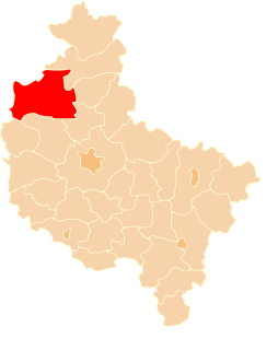
Łosice is a village in the administrative district of Gmina Długołęka, within Wrocław County, Lower Silesian Voivodeship, in south-western Poland. Prior to 1945 it was in Germany.
Kłódka is a village in the administrative district of Gmina Rogóźno, within Grudziądz County, Kuyavian-Pomeranian Voivodeship, in north-central Poland.
Brzeziny is a village in the administrative district of Gmina Siedliszcze, within Chełm County, Lublin Voivodeship, in eastern Poland.
Zaburze is a village in the administrative district of Gmina Żółkiewka, within Krasnystaw County, Lublin Voivodeship, in eastern Poland.
Suchodoły is a village in the administrative district of Gmina Gościeradów, within Kraśnik County, Lublin Voivodeship, in eastern Poland. It lies approximately 10 kilometres (6 mi) west of Kraśnik and 52 km (32 mi) south-west of the regional capital Lublin.
Cierno-Zaszosie is a village in the administrative district of Gmina Jędrzejów, within Jędrzejów County, Świętokrzyskie Voivodeship, in south-central Poland. It lies approximately 8 kilometres (5 mi) west of Jędrzejów and 39 km (24 mi) south-west of the regional capital Kielce.
Borki is a village in the administrative district of Gmina Mrozy, within Mińsk County, Masovian Voivodeship, in east-central Poland.
Lubotyń-Włóki is a village in the administrative district of Gmina Stary Lubotyń, within Ostrów Mazowiecka County, Masovian Voivodeship, in east-central Poland.
Majdan is a village in the administrative district of Gmina Wiązowna, within Otwock County, Masovian Voivodeship, in east-central Poland. It lies approximately 6 kilometres (4 mi) north-west of Wiązowna, 10 km (6 mi) north of Otwock, and 19 km (12 mi) east of Warsaw.
Michałówek is a village in the administrative district of Gmina Wiązowna, within Otwock County, Masovian Voivodeship, in east-central Poland.
Czaplice-Piłaty is a village in the administrative district of Gmina Chorzele, within Przasnysz County, Masovian Voivodeship, in east-central Poland.
Antoniów is a village in the administrative district of Gmina Chlewiska, within Szydłowiec County, Masovian Voivodeship, in east-central Poland. It lies approximately 7 kilometres (4 mi) south-west of Chlewiska, 12 km (7 mi) west of Szydłowiec, and 115 km (71 mi) south of Warsaw.
Kosowo is a village in the administrative district of Gmina Gostyń, within Gostyń County, Greater Poland Voivodeship, in west-central Poland. It lies approximately 8 kilometres (5 mi) west of Gostyń and 56 km (35 mi) south of the regional capital Poznań.
Nowe Potulice is a village in the administrative district of Gmina Lipka, within Złotów County, Greater Poland Voivodeship, in west-central Poland. It lies approximately 4 kilometres (2 mi) south-west of Lipka, 17 km (11 mi) north-east of Złotów, and 121 km (75 mi) north of the regional capital Poznań.

Rogożany is a village in the administrative district of Gmina Kietrz, within Głubczyce County, Opole Voivodeship, in south-western Poland, close to the Czech border. It lies approximately 8 kilometres (5 mi) west of Kietrz, 14 km (9 mi) south-east of Głubczyce, and 64 km (40 mi) south of the regional capital Opole.
Żołna is a village in the administrative district of Gmina Przechlewo, within Człuchów County, Pomeranian Voivodeship, in northern Poland. It lies approximately 12 kilometres (7 mi) north of Przechlewo, 30 km (19 mi) north of Człuchów, and 105 km (65 mi) south-west of the regional capital Gdańsk.
Łazy is a village in the administrative district of Gmina Mielno, within Koszalin County, West Pomeranian Voivodeship, in north-western Poland. It lies approximately 15 kilometres (9 mi) north of Koszalin and 146 km (91 mi) north-east of the regional capital Szczecin.
Pluty is a settlement in the administrative district of Gmina Myślibórz, within Myślibórz County, West Pomeranian Voivodeship, in north-western Poland.