The Wye Valley Walk is a long distance footpath in Wales and England following the course of the River Wye.

The River Usk rises on the northern slopes of the Black Mountain, Wales, in the westernmost part of the Brecon Beacons National Park. Initially forming the boundary between Carmarthenshire and Powys, it flows north into Usk Reservoir, then east by Sennybridge to Brecon before turning southeast to flow by Talybont-on-Usk, Crickhowell and Abergavenny, after which it takes a more southerly course.

Symonds Yat is a village in the Wye Valley and a popular tourist destination, straddling the River Wye in the English county of Herefordshire, close to the Gloucestershire border. It is within a few miles of Monmouthshire and the Welsh border.

The River Wye is the fourth-longest river in the UK, stretching some 250 kilometres from its source on Plynlimon in mid Wales to the Severn Estuary. For much of its length the river forms part of the border between England and Wales. The Wye Valley is designated an Area of Outstanding Natural Beauty. The Wye is important for nature conservation and recreation, but is affected by pollution.

Goodrich is a village and civil parish in south Herefordshire, England close to Gloucestershire and the Forest of Dean, situated near the River Wye at grid reference SO574193. It is known for its Norman and mediaeval castle built with Old Red Sandstone.

Whitchurch is a village in Herefordshire situated on the A40, connecting nearby Ross-on-Wye to Welsh town Monmouth. It is located within the Wye Valley Area of Outstanding Natural Beauty.

Ganarew is a village and small civil parish in south Herefordshire, England near the River Wye and the border with Wales. The village is located 0.62 miles (1.00 km) southwest of the village of Whitchurch on the main A40 road, and lies within the electoral ward of Kerne Bridge. The village is about 2 miles (3.2 km) from Monmouth and 8 miles (13 km) from Ross-on-Wye. It contains the Church of St Swithin and Ganarew Manor.

The Wye Valley is a valley in Wales and England. The River Wye is the fourth-longest river in the United Kingdom.

The A466, also known as the Wye Valley Road, is a road from Hereford, England to Chepstow, Wales via Monmouth, Tintern and the Wye Valley.
Bigsweir Bridge is an 1827 road bridge crossing the River Wye, straddling the boundary between the parish of St. Briavels, Gloucestershire, England, and Llandogo, Monmouthshire, Wales.

The River Gavenny or sometimes the Gavenny River is a short river in Monmouthshire in south Wales. It rises 1 mile (1.6 km) southwest of the village of Llanvihangel Crucorney from springs near Penyclawdd Court, supplemented by springs in Blaen-Gavenny Wood and tributary streams there and within the Woodland Trust-owned Great Triley Wood. It flows south for about 4 miles (6.4 km) to its confluence with the River Usk towards the eastern end of Castle Meadows at Abergavenny. The town derives its English-language name from the Gavenny's confluence with the River Usk. Of the buildings on the banks of the river, the Gothic Decorated style church of St Teilo at Llantilio Pertholey is especially notable. Parts of the church date from the thirteenth century with multiple additions since. Blaengavenny Farm, the name of which signifies the 'head of the Gavenny', is a sixteenth-century farmhouse near the river's source.

The Ross and Monmouth Railway was a standard gauge railway of 13 miles (21 km) which ran between Ross-on-Wye, in Herefordshire, England and Monmouth, Wales.

Bridstow is a village and civil parish in Herefordshire, England, 2 km west of Ross-on-Wye and 17 km south-east of Hereford. The parish is bounded to the east and south by the River Wye. The A40 road linking the M50 motorway to South Wales runs through the parish, crossing the Wye at Bridstow Bridge. The parish had a population of 906 in the 2011 UK census, and an estimated population of 941 in 2018.
The Grosmont Railway was an early horse-drawn railway line in Monmouthshire completed in 1819.

The Wye Bridge in Monmouth is a bridge across the River Wye. The A466 passes over it and immediately meets the A40 at its western end. The bridge is a grade II listed building. The total span of the bridge is 71 metres (233 ft).

The Monmouth Viaduct or Chippenham Meadow Viaduct is a 20-arch 183m red sandstone viaduct, with two 23m steel lattice-girder spans over the river. It carried the Coleford, Monmouth, Usk & Pontypool Railway line across the River Wye at Monmouth, Wales. A further river crossing by the Ross and Monmouth Railway was later built nearby.

Wyastone Leys is a country house estate and Grade II listed building situated near Ganarew, in the southwestern corner of The Doward, in Herefordshire, England. The house and estate has also been known as The Leys or Lays House. It is located 2 miles (3.2 km) from Monmouth and 8 miles (13 km) from Ross-on-Wye. The house is in close proximity to the River Wye and less than 50 metres (160 ft) from the county boundary between Herefordshire and Monmouthshire.
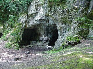
King Arthur's Cave is a limestone cave at the foot of a low cliff at the north-western end of Lord's Wood in The Doward, near Symonds Yat, Herefordshire, about four miles northeast of Monmouth, in the Wye Valley. The cave entrance lies about 285 feet above the River Wye on a hill, with a double interconnected entrance and two main chambers. It is protected as a nature reserve under the Herefordshire Nature Trust. There is evidence that the cave was occupied by man during the Upper Palaeolithic era, and flint tools and woolly mammoth bones have been unearthed within and around the caves.

The Doward, is an area in the parish of Whitchurch in south Herefordshire, England, consisting of the hills of Little Doward and Great Doward and extensive woodland. It is within the Wye Valley Area of Outstanding Natural Beauty, on the border with Monmouthshire, Wales. The area, about 3 miles (4.8 km) north-east of Monmouth, is shrouded in legend and King Arthur's Cave is in the vicinity.

Upper Wye Gorge is a Site of Special Scientific Interest (SSSI), noted for its biological and geological characteristics, around Symonds Yat in the Wye Valley on the Wales–England border. The site is listed in the "Forest of Dean Local Plan Review" as a Key Wildlife Site (KWS).