Symonds Yat

Last updated

Symonds Yat
River Wye at Symonds Yat (9762).jpg
Herefordshire UK location map.svg
Red pog.svg
Symonds Yat
Location within Herefordshire
OS grid reference SO558168
Civil parish
Unitary authority
Ceremonial county
Region
Country England
Sovereign state United Kingdom
Post town ROSS-ON-WYE
Postcode district HR9
Dialling code 01600
Police West Mercia
Fire Hereford and Worcester
Ambulance West Midlands
UK Parliament
List of places
UK
England
Herefordshire
51°50′42″N2°38′46″W / 51.845°N 2.646°W / 51.845; -2.646

Symonds Yat is a village in the Wye Valley and a popular tourist destination, straddling the River Wye in the English county of Herefordshire, close to the Gloucestershire border. It is within a few miles of Monmouthshire and the Welsh border.

Contents

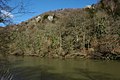
The two settlements either side of the river are known as Symonds Yat (West) and Symonds Yat (East) and are linked by a footbridge and passenger ferries. Nearby is Symonds Yat Rock. The Seven Sisters Rocks are an outcrop of rocks forming cliffs above the Wye at Symonds Yat.

Toponym

The first recorded use of SymondsYat in connection with the area is in a Patent Roll of 1256, where the place appears as Symundesyate and Symondesyate. This may contain the Old English personal name Sigemund or a very early surname deriving from it. Yat represents the Old English word geat (pronounced "yat"), meaning 'gate' and describing the gorge. Although a popular local belief, it is not true that the addition of Symonds was made in the 17th century in reference to Robert Symonds of Sugwas and Evesfield, High Sheriff of Herefordshire in 1685, who was indeed a member of the family who owned the lands from Wormelow near Hereford to the border regions in which surround the Yat. The area is also shown as Symons Yate on maps in 1665, Symons Yat in 1717 and Symmonds Gate in 1830.

History

Bones from hyenas, sabre-toothed cats and a mammoth have been found in and around the caves of the Wye valley. [1] Human habitation can be traced back to 12,000 years ago with findings of their tools and clothes.

In the Iron Age the forts on the Great Doward and Yat Rock provided secure, defensible settlements for the local residents. During Roman times these forts became focal points in the region and the importance of the iron here and in the Forest of Dean made this a valuable prize for the conquerors. The 8th-century earthwork Offa's Dyke runs close to Symonds Yat.

The Yat Gorge was mined for iron ore and remains of a smelting works are located down stream of the Symonds Yat Rapids. [2] The ironworks at New Weir date from the 1590s and were operated by the White family until 1753, when George White leased the site to John Partridge, an ironmonger from Ross on Wye. Partridge combined the ironworks at New Weir with his forge at Lydbrook which smelted pig iron from his furnace at Bishopswood. [3] The works closed when the lease ran out in 1798 and the adjacent weir and lock buildings were demolished and the lock filled in 1814. [3]

The Old Court Hotel in Symonds Yat (West), which was built in the 16th century, [4] was the ancestral home of the Gwillim family and was home to John Graves Simcoe, who was governor and one of the founding fathers of Upper Canada. [5]

The ferry at Symonds Yat has always played a huge part in the life here. In 1800 there were 25 hand ferries between Ross and Chepstow just like those outside Ye Old Ferrie Inn and the Saracen's Head today. They were introduced in Roman times to link the forts of the Doward and the Yat and have served military, civilian, tourist and horse traffic over the years.

Symonds Yat originally encompassed all the lands south of Huntsham curve on both sides of Symonds Yat Rock and would have included the area around Coldwell Rocks. The name Symonds Yat used to refer to quite a large area of land and the hamlet of Symonds Yat (East), consisting of the Saracen's Head Inn, the Fish House, Lockkeepers Cottage and one or two cottages on the hillside, was specifically called New Weir and is seen on maps as such up until 1955.[ citation needed ]

In April 2009 Herefordshire Archaeology excavated New Weir Iron Works at Symonds Yat (West) to establish how the iron works functioned between the start of smelting in and the decline of the works in the 1800s. It was found that the works included a 'slitting mill', for making wire nails and a rolling mill powered by water wheels. [6]

Symonds Yat (East)

Symonds Yat (East) is on the eastern side of the river. It has three hotels, WyeDean Canoe and Activity Centre and the Saracens Head Inn (with accommodation). A steep footpath leads from the village up to Symonds Yat Rock. Another footpath and a cycleway, constructed on a former railway line, runs on the eastern bank to Monmouth.

Symonds Yat (West)

Symonds Yat (West) is on the western side of the river and has a large caravan and camping site. Visitor attractions include the "Amazing Hedge Puzzle" maze built in 1977 to commemorate the Silver Jubilee of Queen Elizabeth II, [7] and the Wye Valley Butterfly Zoo. [8] The main village is Whitchurch with a village shop, The Crown pub and The Potting Shed restaurant, which is in a large 1850s reading room with vaulted ceiling. There is a Grade II listed clock tower, built in 1867 of red brick with a hipped pyramidal slate roof.

River crossings

Hand-pulled ferry over the River Wye at Symonds Yat Symonds Yat ferry canoes.jpg
Hand-pulled ferry over the River Wye at Symonds Yat

Two hand ("pull") cable ferries enable foot passengers to cross the river, powered by ferrymen who pull the ferry across the river using an overhead cable. [9] The only connection by road is upstream over Huntsham bridge; this is a five-mile trip. One ferry is operated by the Saracens Head Inn and the other by the Ye Old Ferrie Inn.

A suspension bridge, Biblins Bridge, was built over the river by the Forestry Commission using local oak timbers in 1957. Linking Symonds Yat (East) to the Biblins camp site, the bridge was fully refurbished in 1997 and rotten timbers and the two support towers were replaced. Although it is designed to take up to 30 people, it has signs requesting that no more than 6 cross at a time. [10]

Geographical features

Symonds Yat Rock

Symonds Yat Rock overlooks a spectacular gorge through which the River Wye snakes. This rock is a good viewpoint from which to watch raptors: a pair of peregrine falcons that nest annually within sight of the rock can be watched through telescopes set up by the RSPB. Buzzards, goshawks and hobbies are also regularly seen and it is sometimes possible to see migrant raptors such as ospreys and European honey buzzards.

Seven Sisters Rocks

The Seven Sisters Rocks are an outcrop of rocks forming cliffs above the Wye, between Symonds Yat and Monmouth. [11]

Local activities

Tourist activities include boat trips, a maze, stand-up paddle boarding (from Ye Old Ferrie Inn), an oriental garden, and a number of country pubs and guest houses.

Symonds Yat Rapids are a grade 2 man-made feature at Symonds Yat used by canoeists and kayakers for whitewater training and playboating. [12]

There is extensive and popular rock climbing on the cliff faces of Carboniferous limestone, with long single pitches at all grades. [13]

Railways

Old railway tunnel at Symonds Yat The entrance revealed (3519050121).jpg
Old railway tunnel at Symonds Yat

Symonds Yat station, on the east side of the river, was on the Ross and Monmouth Railway that ran from Ross-on-Wye to Monmouth Troy between 1873 and 1959 through the Wye Valley. A trace of this remains at Symonds Yat Tunnel.

Media

Related Research Articles

<span class="mw-page-title-main">Wye Valley Walk</span> Long-distance footpath in Wales and England

The Wye Valley Walk is a long distance footpath in Wales and England following the course of the River Wye.

<span class="mw-page-title-main">Forest of Dean</span> Geographical, historical and cultural region in England

The Forest of Dean is a geographical, historical and cultural region in the western part of the county of Gloucestershire, England. It forms a roughly triangular plateau bounded by the River Wye to the west and northwest, Herefordshire to the north, the River Severn to the south, and the City of Gloucester to the east.

<span class="mw-page-title-main">River Wye</span> River in Wales and England

The River Wye is the fourth-longest river in the UK, stretching some 250 kilometres from its source on Plynlimon in mid Wales to the Severn Estuary. For much of its length the river forms part of the border between England and Wales. The Wye Valley is designated an Area of Outstanding Natural Beauty. The Wye is important for nature conservation and recreation, but is affected by pollution.

<span class="mw-page-title-main">Coleford, Gloucestershire</span> Market town in Gloucestershire, England

Coleford is a market town in the west of the Forest of Dean, Gloucestershire, England, two miles (3 km) east of the Welsh border and close to the Wye Valley. It is the administrative centre of the Forest of Dean district. The combined population of the town's two electoral wards at the 2011 census was 8,359. The population of the town's parish was 9,273 in the 2021 Census. The parish includes the village of Baker's Hill.

<span class="mw-page-title-main">Whitchurch, Herefordshire</span> Human settlement in England

Whitchurch is a village in Herefordshire situated on the A40, connecting nearby Ross-on-Wye to Welsh town Monmouth. It is located within the Wye Valley Area of Outstanding Natural Beauty.

<span class="mw-page-title-main">Chepstow railway station</span> Grade II listed railway station in Monmouthshire, Wales

Chepstow railway station is a part of the British railway system owned by Network Rail and is operated by Transport for Wales. Chepstow station is on the Gloucester to Newport Line, 141 miles 33 chains (227.6 km) from the zero point at Paddington, measured via Stroud. It is 330 yards (300 m) from the town centre, at Station Road. Chepstow is a historic walled border town and ancient port, situated at the southern end of the Wye Valley, two hours from London.

<span class="mw-page-title-main">Wye Valley</span> Area of Outstanding Natural Beauty in England and Wales

The Wye Valley Area of Outstanding Natural Beauty is an internationally important protected landscape straddling the border between England and Wales.

<span class="mw-page-title-main">Symonds Yat Rapids</span> Rapids on the River Wye in England, United Kingdom

Symonds Yat Rapids are a grade-2 man-made feature on the River Wye, near Symonds Yat on the Gloucestershire and Herefordshire border. They are most commonly used by canoeists and kayakers for whitewater training and playboating.

<span class="mw-page-title-main">Brockweir</span> Human settlement in England

Brockweir is a village in Hewelsfield and Brockweir civil parish, in the Forest of Dean District of Gloucestershire, England. The civil parish also includes the separate village of Hewelsfield.

<span class="mw-page-title-main">Redbrook</span> Village in Gloucestershire, England

Redbrook is a village in Gloucestershire, England, adjoining the border with Monmouthshire, Wales. It is located on the River Wye and is within the Wye Valley Area of Outstanding Natural Beauty.

<span class="mw-page-title-main">Lady Park Wood National Nature Reserve</span>

Lady Park Wood National Nature Reserve is a 45-hectare (110-acre) nature reserve straddling the borders of Gloucestershire in England and Monmouthshire in Wales. Most of the wood is in Wales – where it forms Wales' easternmost point – but it is managed under agreement with Natural England.

<span class="mw-page-title-main">Ross and Monmouth Railway</span>

The Ross and Monmouth Railway was a standard gauge railway of 13 miles (21 km) which ran between Ross-on-Wye, in Herefordshire, England and Monmouth, Wales.

<span class="mw-page-title-main">Symonds Yat railway station</span> Former railway station in Herefordshire, England

Symonds Yat railway station is a disused railway station on the Ross and Monmouth Railway constructed on the banks of the River Wye in Symonds Yat East.

The Wye Tour was an excursion past and through a series of scenic buildings, natural phenomena, and factories located along the River Wye. It was a popular destination for British travellers from 1782 to around 1850, and reached its peak popularity during the Napoleonic Wars, when travel to Continental Europe was not an option.

The geology of Monmouthshire in southeast Wales largely consists of a thick series of sedimentary rocks of different types originating in the Silurian, Devonian, Carboniferous, Triassic and Jurassic periods.

The Monmouth Railway, also known as the Monmouth Tramroad, was a horse-drawn plateway of 3 ft 6in gauge. It ran for about 5 miles (8.0 km) from Howler's Slade, east of Coleford, in Gloucestershire and Monmouth; there were two branches from other mineral sites. It was intended to bring mineral products of the Forest of Dean to Monmouth, and to the works alongside the River Wye.

<span class="mw-page-title-main">The Doward</span> Human settlement in England

The Doward, is an area in the parish of Whitchurch in south Herefordshire, England, consisting of the hills of Little Doward and Great Doward and extensive woodland. It is within the Wye Valley Area of Outstanding Natural Beauty, on the border with Monmouthshire, Wales. The area, about 3 miles (4.8 km) north-east of Monmouth, is shrouded in legend and King Arthur's Cave is in the vicinity.

<span class="mw-page-title-main">Upper Wye Gorge</span>

Upper Wye Gorge is a Site of Special Scientific Interest (SSSI), noted for its biological and geological characteristics, around Symonds Yat in the Wye Valley on the Wales–England border. The site is listed in the 'Forest of Dean Local Plan Review' as a Key Wildlife Site (KWS).

<span class="mw-page-title-main">Kerne Bridge (River Wye crossing)</span> Historic road bridge in Herefordshire, UK

Kerne Bridge was built over the River Wye in the County of Herefordshire, England in 1825–28, on the site of an ancient ford crossing known as Flanesford. It is designated as a Scheduled Monument. Carrying the B4229 road, it connects the parishes of Walford on the river's left bank and Goodrich on the right. It is situated in the heart of the Wye Valley Area of Outstanding Natural Beauty and marks the northern end of the Upper Wye Gorge.

<span class="mw-page-title-main">Biblins Bridge</span> Bridge in Wye Valley

Biblins Bridge is a footbridge which crosses the River Wye between England and Wales, near Symonds Yat. The present structure dates from 1957, although there has been a crossing at this point since the early 20th century.

References

  1. Phelps, David (2022). 50 Gems of Herefordshire. Amberley. p. 71. ISBN   9781398104242.
  2. "A Brief History" . Retrieved 23 September 2010.
  3. 1 2 Hodges, Dave. "The Ironworks of the Wye Valley". Archived from the original on 13 March 2012. Retrieved 23 September 2010.
  4. "Old Court Hotel". historicengland.org.uk. English Heritage. Retrieved 30 December 2010.
  5. "Wyenot?" . Retrieved 23 September 2010.
  6. "Excavation at New Weir Iron Works, Symonds Yat West". Archived from the original on 10 June 2011. Retrieved 23 September 2010.
  7. "Meet the Maze Makers". Archived from the original on 5 October 2010. Retrieved 23 September 2010.
  8. "Wye Valley Butterfly Zoo" . Retrieved 23 September 2010.
  9. "Access between Symonds Yat West and Symonds Yat East by pedestrian ferry and footbridge". Archived from the original on 29 April 2010. Retrieved 23 September 2010.
  10. Molesworth, I.D. "A Study of Biblins Footbridge" (PDF). Archived from the original (PDF) on 23 December 2018. Retrieved 31 March 2020.
  11. "Seven Sisters Rocks, Symonds Yat". Collections. University of St Andrews . Retrieved 3 February 2021.
  12. "Symonds Yat Rapids Management Group" . Retrieved 23 September 2010.
  13. "Regional Access Database: Symonds Yat". British Mountaineering Council. Retrieved 18 September 2012.