English Bicknor

Last updated

English Bicknor
St.Mary's church - geograph.org.uk - 1353151.jpg
Parish church of St Mary the Virgin
Gloucestershire UK location map.svg
Red pog.svg
English Bicknor
Location within Gloucestershire
Population408 (2011 Census)
OS grid reference SO581156
Civil parish
  • English Bicknor
District
Shire county
Region
Country England
Sovereign state United Kingdom
Post town Coleford
Postcode district GL16
Dialling code 01594
Police Gloucestershire
Fire Gloucestershire
Ambulance South Western
UK Parliament
Website The Parish of English Bicknor
List of places
UK
England
Gloucestershire
51°50′17″N2°36′32″W / 51.838°N 2.609°W / 51.838; -2.609 Coordinates: 51°50′17″N2°36′32″W / 51.838°N 2.609°W / 51.838; -2.609

English Bicknor is a village and civil parish in the Forest of Dean district of west Gloucestershire, England. The 2011 Census recorded the population as 408. [1] The village is near the county boundary with Herefordshire, opposite which is the village of Welsh Bicknor. The two villages are on opposite sides of the River Wye.

Contents

History

The Domesday Book of 1086 records Bicknor as Bicanofre. The second morpheme of the toponym, ōfer, is thought to come from the Old English for river bank, referring to the two villages' positions either side of the river. Various hypotheses have been put forward for the origin of the first morpheme in the name, but may mean a place belonging to Bica. [2]

English Bicknor is one of the ancient villages of the Forest of Dean, situated at the top of a hill overlooking the Wye Valley, and once the site of English Bicknor Castle, a motte and bailey castle, the remnants of which can still be seen. [3] Close to the village is Bicknor Court, an imposing house some 400 years old. [4] Situated between Symond's Yat and Lower Lydbrook on high ground opposite its namesake Welsh Bicknor. English Bicknor is first recorded as a hamlet in 1066. [5]

The parish is primarily agricultural and industrial. Its main attraction is the small Norman Church of England parish church of St Mary the Virgin which has notable internal 12th-century stonemasonry and sculpture. [6] The church is in the outer courtyard of the motte-and-bailey castle. Norman masonry has been found in the motte, suggesting at least part was built in stone. Nothing of the castle's structure survives, but its location remains identifiable.

A typical early Norman defence work which is one of many along the Welsh Marches, it is thought to have been built in the reign of Henry I of England (1100–35) or King Stephen (1135–54) and was demolished or destroyed by the late 14th century, but why and how is not known (possibly during the rebellion of Owain Glyndŵr). [7]

Parish church

15th-century ledger stone in St Mary's inscribed with Lombardic script Lombardic script, cross-slab, English Bicknor - geograph.org.uk - 1416937.jpg
15th-century ledger stone in St Mary's inscribed with Lombardic script

The parish church is Norman, built in the 12th century. It is in an oval churchyard of Anglo-Saxon origin within the outer courtyard of a Norman motte-and-bailey castle. The exterior walls were restored in the Victorian era. Only the exterior stonework of the 13th-century west tower is original. Earlier the church had a crossing tower, but was it built from the soft local sandstone which became unsafe. [8] [6]

Inside the church, both the four-bay north arcade and five-bay south arcade are Norman Romanesque, but their capitals have different decoration. The font is also Norman. The church has also a stained glass window made by Percy Bacon in 1908. [9]

Monuments in the church include a ledger stone from about 1420 with a rare example of Lombardic script that translates "Pray for the soul of our departed brother in Christ". Other monuments include three Mediæval stone figures. Cecilia Muchegros, who lived in the village and died in 1301, and Hawisia, who died in 1353 and whose figure is dressed in a long flowing robe, each have a dog at their feet. The third figure is of a priest, with an old body and a young head. It is not known who he was, but may have been the priest in the church in the early 14th century.

The west tower has a ring of six bells. Abraham I Rudhall of Gloucester cast five bells including the tenor in 1709 and the treble bell in 1718. The church has also a Sanctus bell cast by John Warner & Sons of Cripplegate, London in 1875. [10]

St Mary's is a Grade I listed building. [9]

Governance

The village is in the Christchurch and English Bicknor electoral ward. This ward centres on Christchurch but starts in the north at English Bicknor and includes Staunton Coleford in the southwest. The 2011 Census recorded the ward population as 1,520. [11]

Related Research Articles

Forest of Dean Geographical, historical and cultural region in Gloucestershire, England

The Forest of Dean is a geographical, historical and cultural region in the western part of the county of Gloucestershire, England. It forms a roughly triangular plateau bounded by the River Wye to the west and northwest, Herefordshire to the north, the River Severn to the south, and the City of Gloucester to the east.

Forest of Dean District Non-metropolitan district in England

Forest of Dean is a local government district in Gloucestershire, England, named after the Forest of Dean. Its council is based in Coleford. Other towns and villages in the district include Blakeney, Cinderford, Drybrook, English Bicknor, Huntley, Littledean, Longhope, Lea, Lydbrook, Lydney, Mitcheldean, Newnham and Newent

St Briavels Human settlement in England

St Briavels, is a medium-sized village and civil parish in the Royal Forest of Dean in west Gloucestershire, England; close to the England-Wales border, and 5 miles (8 km) south of Coleford. It stands almost 800 feet (240 m) above sea level on the edge of a limestone plateau above the valley of the River Wye, above an ancient meander of the river. To the west, Cinder Hill drops off sharply into the valley. It is sheltered behind the crumbling walls of the 12th century St Briavels Castle.

Alvington, Gloucestershire Human settlement in England

Alvington is a village and civil parish in the Forest of Dean in Gloucestershire, England, situated on the A48 road, six miles north-east of Chepstow in Wales. The parish had a total population of 506 at the 2011 census.

Awre Human settlement in England

Awre is a village, civil parish and electoral ward in the Forest of Dean district of Gloucestershire, England, near the River Severn.

St Briavels Castle Grade I listed castle in Forest of Dean, United Kingdom

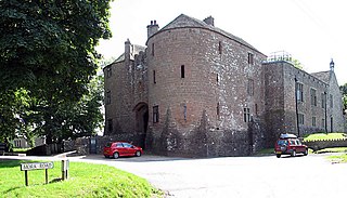
St Briavels Castle is a moated Norman castle at St Briavels in the English county of Gloucestershire. The castle is noted for its huge Edwardian gatehouse that guards the entrance.

A466 road road in England and Wales

The A466, also known as the Wye Valley Road, is a road from Hereford, England to Chepstow, Wales via Monmouth, Tintern and the Wye Valley.

Drybrook Human settlement in England

Drybrook is a village and civil parish in the Forest of Dean in west Gloucestershire, England..

Littledean Human settlement in England

Littledean is a village in the Forest of Dean, west Gloucestershire, England. The village has a long history and formerly had the status of a town. Littledean Hall was originally a Saxon hall, although it has been rebuilt and the current house dates back to 1612. The remains of a Roman temple are situated in the grounds. Neither the hall or Roman remains are open to the public.

Clearwell Human settlement in England

Clearwell is a village and former ancient manor in the Forest of Dean, West Gloucestershire, England. A recent survey indicated that the population of Clearwell is approximately 350.

Alexander de Bicknor was an official in the Plantagenet kingdom under Edward I of England, Edward II of England, and Edward III of England. Best known to history as the Archbishop of Dublin from 1317 until his death in 1349, his career involved extensive diplomatic missions for the King and the holding of numerous civil and ecclesiastical offices in Ireland, including Lord Treasurer of Ireland (1307–1309) and Lord Chancellor of Ireland.

Oaksey Village in Wiltshire

Oaksey is a village and civil parish in Wiltshire, England, on the county boundary with Gloucestershire. The village is about 5.5 miles (8.9 km) northeast of the market town of Malmesbury and a similar distance south of the Gloucestershire market town of Cirencester.

East Dean was a township, and later civil parish, in Gloucestershire, England. It was created as a township in 1844 and abolished as a civil parish in 1953. Its former area is now part of the Forest of Dean district.

Hewelsfield Human settlement in England

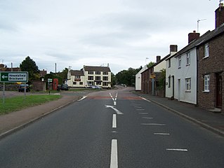
Hewelsfield is a village in Hewelsfield and Brockweir civil parish, in the Forest of Dean district of Gloucestershire, England.

English Bicknor Castle

English Bicknor Castle was a castle in the village of English Bicknor in Gloucestershire, England.

Bledisloe Hundred

Bledisloe was an ancient hundred of Gloucestershire, England. It comprised the ancient parishes of

St Briavels Hundred

St Briavels was an ancient hundred of Gloucestershire, England. It comprised the extra-parochial area of the Forest of Dean, and the ancient parishes of

Eastbach Court house in English Bicknor, Gloucestershire, UK

Eastbach Court is a historic Grade II listed mansion in English Bicknor, Gloucestershire, England.

Hewelsfield and Brockweir Human settlement in England

Hewelsfield and Brockweir is a civil parish in Forest of Dean District, Gloucestershire. The parish was called Hewelsfield until 1994. It contains two distinct villages, Hewelsfield and Brockweir, with scattered settlement on Hewelsfield common.

References

  1. "Area: English Bicknor (Parish): Key Figures for 2011 Census: Key Statistics". Neighbourhood Statistics . Office for National Statistics. Archived from the original on 2 April 2015. Retrieved 26 March 2015.
  2. Ekwall, Eilert (1960). The Concise Oxford Dictionary of English Place Names. Oxford University Press. p. 41. ISBN   978-0-19-869103-7.
  3. "Motte and bailey castle at English Bicknor". National Heritage List for England. Historic England. Archived from the original on 24 August 2020. Retrieved 24 August 2020.
  4. "Bicknor Court". National Heritage List for England. Historic England. Archived from the original on 24 August 2020. Retrieved 24 August 2020.
  5. "English Bicknor Pages 101-117 A History of the County of Gloucester: Volume 5, Bledisloe Hundred, St. Briavels Hundred, the Forest of Dean". British History Online. Victoria County History. Archived from the original on 11 June 2020. Retrieved 24 August 2020.
  6. 1 2 "St Mary's Church". The Parish of English Bicknor. Archived from the original on 29 April 2017. Retrieved 24 August 2020.
  7. "English Bicknor Castle". Gatehouse. Archived from the original on 7 April 2016. Retrieved 24 August 2020.
  8. "Church English Bicknor Pages 101-117 A History of the County of Gloucester: Volume 5, Bledisloe Hundred, St. Briavels Hundred, the Forest of Dean". British History Online. Victoria County History. Archived from the original on 11 June 2020. Retrieved 24 August 2020.
  9. 1 2 Historic England. "Church of St Mary the Virgin  (Grade I) (1289658)". National Heritage List for England . Retrieved 21 November 2017.
  10. Higson, Andrew (8 August 2012). "English Bicknor, Glos, S Mary". Dove's Guide for Church Bell Ringers . Central Council for Church Bell Ringers. Archived from the original on 24 August 2020. Retrieved 21 November 2017.
  11. "Christchurch and English Bicknor ward 2011". Archived from the original on 5 March 2016. Retrieved 26 March 2016.

Further reading