
Eynsford is a village and civil parish in the Sevenoaks District of Kent, England. It is located 3.3 miles (5 km) south east of Swanley, 7 miles (11 km) south of Dartford and 7.7 miles (12 km) north of Sevenoaks.

The Palatinate Forest, sometimes also called the Palatine Forest, is a low-mountain region in southwestern Germany, located in the Palatinate in the state of Rhineland-Palatinate. The forest is a designated nature park covering 1,771 km2 and its highest elevation is the Kalmit.

Dahn is a municipality in the Südwestpfalz district, in Rhineland-Palatinate, Germany. It is situated in the Palatinate Forest, approximately 15 km southeast of Pirmasens, and 25 km west of Landau. It is part of the Verbandsgemeinde of Dahner Felsenland.

Birkenhördt is a municipality in the Südliche Weinstraße district, in Rhineland-Palatinate, Germany, and is an officially recognized tourist resort.
Erfweiler is a municipality in Südwestpfalz district, in Rhineland-Palatinate, western Germany. It is a state-recognised resort.

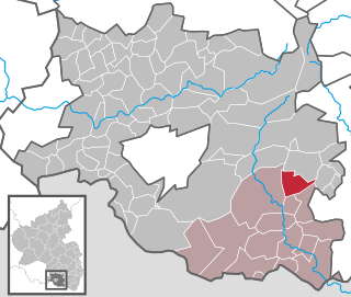
Wilgartswiesen is a municipality in Südwestpfalz district, in Rhineland-Palatinate, western Germany.

The Battle of Gnila Lipa took place early in the World War I on 29–30 August 1914, when the Imperial Russian Army invaded Galicia and engaged the defending Austro-Hungarian Army. It was part of a larger series of battles known collectively as the Battle of Galicia. The battle ended in a defeat of the Austro-Hungarian forces.

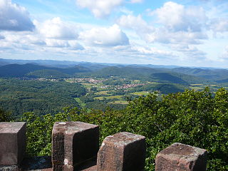
The Devil's Table in Hinterweidenthal is a 14 metre high mushroom rock in the German part of the Wasgau region, the southern Palatine Forest in the state of Rhineland-Palatinate). Thanks to its location in the territory of the village of Kaltenbach - formerly part of Wilgartswiesen – it is often called the Kaltenbach Devil's Table, especially in old literary sources. It is larger and better known than the Devil's Table of Salzwoog, which is only 5 kilometres away to the southwest.
Devil's Table (German:Teufelstisch) may refer to the following landforms in Germany:
The Wasgau is a Franco-German hill range in the German state of Rhineland-Palatinate and the French departments of Bas-Rhin and Moselle. It is formed from the southern part of the Palatine Forest and the northern part of the Vosges mountains, and extends from the River Queich in the north over the French border to the Col de Saverne in the south.
The German Shoe Road is one of several tourist-oriented, themed routes in southern Rheinhessen and in the West Palatinate in the German state of Rhineland-Palatinate. It is a circular route of more than 300 km largely running within the Palatine Forest-North Vosges Biosphere Reserve often on scenic secondary roads.
The Südliche Weinstraße Wildlife Park is located in the Wasgau, a region on the Franco-German border that forms the southern part of the Palatine Forest and the northern part of the Vosges, near the village of Silz in the south of the state of Rhineland-Palatinate. The park is not named after the German Wine Route which passes about 6 kilometres away, but after the county of Südliche Weinstraße. The tourist attraction receives about 100,000 visitors annually.
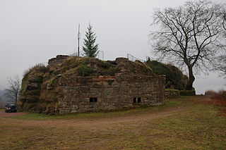
Scharfenberg Castle, is the ruin of a medieval rock castle in the Palatine Forest in the German state of Rhineland-Palatinate. It is situated above the small South Palatine town of Annweiler.
The Erlenbach is a stream, over 9 km long, in the South Palatine Wasgau region of the German state of Rhineland-Palatinate. It is a left tributary of the Lauter which, here in its upper reaches is still called the Wieslauter.
The Salzbach, which is initially called the Kröppenbach and then the Buchbach, is with a length of around 17 kilometres (11 mi) the longest tributary of the Lauter, which here in its upper reaches is known as the Wieslauter. It flows through the northwestern Wasgau, a hill range which comprises the southern part of the Palatinate Forest in the German state of Rhineland-Palatinate and the northern part of the Vosges in the French departments of Bas-Rhin and Moselle.
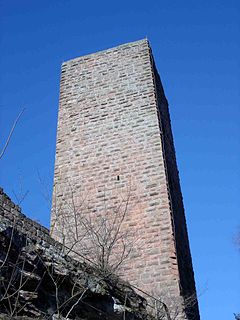
Lemberg Castle is a medieval castle on the territory of Lemberg in the county of Südwestpfalz in the German state of Rhineland-Palatinate.

Ruppertstein Castle is the ruins of a hill castle located at an elevation of 452 m above sea level (NN) near the village of Lemberg in the collective municipality of Pirmasens-Land in the county of Südwestpfalz in the German state of Rhineland-Palatinate. It is situated on top of the Ruppertstein hill south of the village of Ruppertsweiler.

The Devil's Table of Salzwoog, in the municipality of Lemberg, is a striking mushroom rock in the German part of the Wasgau that covers the southern part of the Palatinate Forest in the state of Rhineland-Palatinate. The rock formation lies 5 km southwest of the largest and far better known Devil's Table of Hinterweidenthal, which also has a more impressive "table shape".

The Heidenberg is a 420-metre-high hill in the southeastern Wasgau, the region that covers the southern part of the Palatinate Forest in Germany and the northern Vosges in France. The Heidenberg's north flank is in the parish of Busenberg, its south flank in the parish of Erlenbach bei Dahn.

The Hohe Derst is a hill, 561 metres above sea level, in the Palatine Forest of southwest Germany. It lies within the Wasgau region and is the highest point of the Mundat Forest.
