Paradise is a town on the Avalon Peninsula in the province of Newfoundland and Labrador, Canada. Paradise is the third largest settlement in the province and is part of the St. John's metropolitan area, the 20th largest metropolitan area in Canada. The town borders the City of St. John's, the City of Mount Pearl, the Town of Portugal Cove-St. Philip's, and the town of Conception Bay South.
Conception Harbour is a town on the Avalon Peninsula in Newfoundland and Labrador, Canada. It is in Division 1 on Conception Bay and can be accessed via Newfoundland and Labrador Route 60.

Division 1, Newfoundland and Labrador is a census division covering the entire Avalon Peninsula including the Isthmus of Avalon of the Canadian province of Newfoundland and Labrador. Like all census divisions in Newfoundland and Labrador, but unlike the census divisions of some other provinces, the division exists only as a statistical division for census data, and is not a political entity.

Avalon is a federal electoral district on Newfoundland Island in Newfoundland and Labrador, Canada. It has been represented in the House of Commons of Canada since 2004.

St. John's East is a federal electoral district in Newfoundland and Labrador, Canada, that has been represented in the House of Commons of Canada since 1949.

Bell Island is an island that is part of Newfoundland and Labrador, Canada's easternmost province. With an area of 34 square kilometres (13 sq mi), it is by far the largest island in Conception Bay, a large bay in the southeast of the island of Newfoundland. The provincial capital of St. John's is less than 20 kilometres (12 mi) to the east.

Conception Bay South is a town in the Province of Newfoundland and Labrador, Canada. The town is commonly called CBS.
Conception Bay (CB) is a bay on the southeast coast of Newfoundland, Canada.

Grates Cove is a local service district and designated place in the Canadian province of Newfoundland and Labrador. It is the most northerly community on the Avalon Peninsula, located on the tip of the Bay de Verde Peninsula on the island of Newfoundland. Called "the Grates" by John Guy as early as 1612, the origin of the name is unknown.
The Bay de Verde Peninsula is the largest peninsula that makes up part of the Avalon Peninsula, of the province of Newfoundland and Labrador, Canada. The peninsula separates both Trinity and Conception Bay.
Victoria is an incorporated town in Conception Bay located approximately midway on the Bay de Verde Peninsula of Newfoundland and Labrador, Canada.
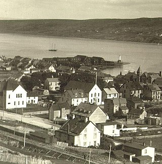
Harbour Grace is a town in Conception Bay on the Avalon Peninsula in the province of Newfoundland and Labrador, Canada. With roots dating back to the 16th century, it is one of the oldest towns in North America.

Portugal Cove–St. Philip's is a rural seashore community located on the eastern Avalon Peninsula of Newfoundland in the province of Newfoundland and Labrador, Canada. The town is a bedroom community of the provincial capital of St. John's.

The East Coast Trail (ECT) is a long-distance coastal footpath located in the Canadian province of Newfoundland and Labrador. It is a developed trail over 336 kilometres (209 mi) long, creation of which began in 1994. It is made up of 25 linked wilderness paths and passes through more than 30 communities. It was named one of the best adventure destinations by National Geographic in 2012 and is extended and improved yearly.
Bay de Verde is an incorporated town in Conception Bay on the northern tip of the Bay de Verde Peninsula of Newfoundland and Labrador, Canada. The first recorded inhabitants at Bay de Verde arrived in 1662. Bay de Verde became an incorporated town in 1950.

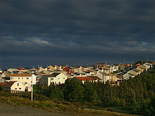
Wabana is a Canadian town and the largest, and only incorporated, community on Bell Island in the province of Newfoundland and Labrador.
South River is an incorporated municipality in the Canadian province of Newfoundland and Labrador, located at the south-southeast side of Bay de Grave, in Conception Bay. The town had a population of 674 according to the 2021 Canadian Census. South River is the site of the western terminus of Newfoundland and Labrador Route 60, also known as the Conception Bay Highway, which proceeds eastward to downtown St. John's. The river itself forms a natural boundary with neighbouring Clarke's Beach and is a scheduled salmon river. A second river, known as the Gould Brook, forms another natural boundary with the unincorporated local service district of Makinsons. South River is home to the Bay de Grave Regional Fire Department, a first step in developing successful regional cooperation amongst municipalities.
Lance Cove, Newfoundland and Labrador is a local service district and designated place in the Canadian province of Newfoundland and Labrador.

Division No. 1, Subdivision G is an unorganized subdivision on the Avalon Peninsula in Newfoundland and Labrador, Canada. It is in Division 1 and contains the unincorporated communities of Baccalieu Island, Besom Cove, Bradley's Cove, Burnt Point, Caplin Cove, Daniel's Cove, Grates Cove, Gull Island, Job's Cove, Kingston, Long Beach, Lower Island Cove, Low Point, Northern Bay, Ochre Pit Cove, Red Head Cove, Riverhead, Smooth Cove and Western Bay.

