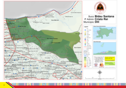
Bidau Santana

Last updated
Bidau Santana
Bidau Santana suco.png
Map of Bidau Santana
East Timor adm-2 location map.svg
Red pog.svg
Bidau Santana
Location in East Timor
Coordinates: 8°32′56″S125°35′35″E / 8.54889°S 125.59306°E / -8.54889; 125.59306 Coordinates: 8°32′56″S125°35′35″E / 8.54889°S 125.59306°E / -8.54889; 125.59306
Country Flag of East Timor.svg  East Timor
Municipality Dili
Administrative posts Cristo Rei
Area
  Total1.84 km2 (0.71 sq mi)
Population
 (2015) [1]
  Total6,482
Time zone UTC +9

Bidau Santana is a suco in Cristo Rei Administrative Post, Dili Municipality, East Timor. [2] The administrative area covers an area of 1.84 square kilometres and at the time of the 2015 census it had a population of 6,482 people. [1]

Geography

Bidau Santana is located to the west of the Cristo Rei Administrative Post, at the east end of the Bay of Dili. Northeast lies Meti Aut, east of the Camea and south of Becora and Culu Hun. To the west, beyond Mota Bidau, is the administrative office of Nain Feto, to which Bidau Santana belonged to until 2004. Becora is bordered by the Benamauc River, which forms the Mota Claran together with the Rio Bemori and flows into the Bay of Dili. Since the municipal reform in 2015, Bidau Santana has an area of 1.84 km2 (0.71 sq mi). [1]

Bidau Santana is divided into four Aldeias. Bidau Mota Claran, Manu Mata and Toko Baru to the west and Sagrada Familia to the east, occupying more than two-thirds of the Suco's area. [3] [4] A distinction is also made between the aldeias of Bidau Santana on the coast and Mota Claran in the southwest and Masau in the center. [5] In the suco, there is a primary school in Masau, [4] the Escola Primaria No. 2 Bidau Masau. [6] Two Marian grottos with additional extensions are striking: the Gruta de Bidau Masau and the Gruta de Bidau Santana. In 2019, the B. J. Habibie Bridge was inaugurated [7] and the Jardim B.J. Habibie park opened next to it. [8]

Related Research Articles

<span class="mw-page-title-main">Dili</span> Capital and largest city of East Timor

Dili is the capital and largest city of East Timor. It lies on the northern coast of the island of Timor, in a small area of flat land hemmed in by mountains. The climate is tropical, with distinct wet and dry seasons. The city has served as the economic hub and chief port of what is now East Timor since its designation as the capital of Portuguese Timor in 1769. It also serves as the capital of the Dili Municipality, which includes some rural subdivisions in addition to the urban ones which make up the city itself. Dili's growing population is relatively youthful, being mostly of working age. The local language is Tetum, however residents include many internal migrants from other areas of the country.

<span class="mw-page-title-main">Municipalities of East Timor</span>

East Timor is divided into 14 municipalities, one of which is also a Special Administrative Region. The municipalities are divided into administrative posts, and further subdivided into sucos (villages). Atauro Island was initially part of Dili Municipality, but became a separate municipality on 1 January 2022.

<span class="mw-page-title-main">Sahen River</span> River in East Timor

The Sahen River is a river in East Timor. It originates in central Manatuto municipality, flows in a mostly southerly direction, and then discharges into the Timor Sea at the southern tip of the border between Manatuto and Manufahi municipalities.

<span class="mw-page-title-main">Comoro River</span> River in East Timor

The Comoro River is a river in East Timor. It flows north into Ombai Strait, reaching the coast in the north western suburbs of the capital, Dili. In its lower reaches, it is the main and largest of Dili's four major rivers.

<span class="mw-page-title-main">Subdivisions of East Timor</span>

East Timor is divided into:

<span class="mw-page-title-main">Cristo Rei Administrative Post</span> Administrative post in Dili Municipality, East Timor

Cristo Rei, officially Cristo Rei Administrative Post, is an administrative post in Dili municipality, East Timor. Its seat or administrative centre is Becora, and its population at the 2010 census was 54,936.

<span class="mw-page-title-main">Luro Administrative Post</span> Administrative post in Lautém Municipality, East Timor

Luro, officially Luro Administrative Post, is an administrative post in Lautém municipality, East Timor; Luro is also the name of two of its towns.

<span class="mw-page-title-main">Aissirimou</span> Suco in Aileu, East Timor

Aissirimou is a village and suco in Aileu Subdistrict, Aileu District, East Timor. The administrative area covers an area of 29.81 square kilometres and at the time of the 2010 census it had a population of 2192 people.

<span class="mw-page-title-main">Bandudato</span> Suco in Aileu, East Timor

Bandudato is a suco of Aileu subdistrict, Aileu District, East Timor. The administrative area covers an area of 30.65 square kilometres and at the time of the 2010 census it had a population of 1,426 people.

<span class="mw-page-title-main">Hoholau</span> Suco in Aileu, East Timor

Hoholau is a suco in Aileu subdistrict, Aileu District, East Timor. The administrative area covers an area of 16.72 square kilometers and, at the time of the 2010 census, it had a population of 766 people

<span class="mw-page-title-main">Lahae</span> Suco in Aileu, East Timor

Lahae is a suco in Aileu subdistrict, Aileu District, East Timor. The administrative area covers an area of 13.64 square kilometres and at the time of the 2010 census it had a population of 1061 people.

<span class="mw-page-title-main">Seloi Malere</span> Suco in Aileu, East Timor

Seloi Malere is a suco in Aileu subdistrict, Aileu District, East Timor. The administrative area covers an area of 13 square kilometres and at the time of the 2010 census it had a population of 3676 people.

<span class="mw-page-title-main">Fatisi</span> Suco in Aileu, East Timor

Fatisi is a suco in Laulara subdistrict, Aileu District, East Timor. The administrative area covers an area of 11.82 square kilometres and at the time of the 2010 census it had a population of 1156 people.

<span class="mw-page-title-main">Cacavei</span>

Cacavei is a village (suco) in East Timor. It is located in Lospalos sub-district and Lautem district. This village is in between Lospalos town and Iliomar sub-district.

<span class="mw-page-title-main">Fatululic Administrative Post</span> Administrative post in Cova Lima Municipality, East Timor

Fatululic, officially Fatululic Administrative Post, is an administrative post in Cova Lima municipality, East Timor. Its seat or administrative centre is Fatululic.

<span class="mw-page-title-main">Bandeira Waterfall</span> Waterfall in East Timor

The Bandeira Waterfall is a tall waterfall in the municipality of Ermera, East Timor. It forms part of a minor tributary of the Loes River.

<span class="mw-page-title-main">Berloi Waterfall</span> Waterfall in East Timor

The Berloi Waterfall is a small waterfall in the municipality of Aileu, East Timor. It forms part of a minor tributary of the Comoro River.

The B. J. Habibie Bridge is a two-lane road bridge in the suco of Bidau Santana, an inner suburb of Dili, capital city of East Timor. It is named after B. J. Habibie, the President of Indonesia who decided in 1999 to hold that year's referendum on whether East Timor would become independent of Indonesia.

<span class="mw-page-title-main">Bay of Dili</span> Bay in East Timor

The Bay of Dili is a bay on the north coast of East Timor adjacent to Dili, its capital city. The bay forms part of Ombai Strait, which separates the Alor Archipelago from the islands of Wetar, Atauro, and Timor in the Lesser Sunda Islands.

<span class="mw-page-title-main">Cape Fatucama</span> Cape or large headland near Dili, East Timor

Cape Fatucama is a cape or large headland a short distance north east of Dili, on the north coast of East Timor. It is best known as the site of the Cristo Rei of Dili, a colossal statue of Jesus Christ.

References

  1. 1 2 3 "Ergebnisse der Volkszählung von 2015". Direcção-Geral de Estatística . Retrieved 23 November 2016.
  2. "PUBLICAÇÃO OFICIAL DA REPÚBLICA DEMOCRÁTICA DE TIMOR - LESTE" (PDF). Jornal da República, Government of East Timor. 16 September 2009. Archived from the original (PDF) on 1 March 2012. Retrieved 21 July 2012.
  3. "Jornal da Républica mit dem Diploma Ministerial n.° 199/09" (PDF). www.jornal.gov.tl (in Portuguese). Archived from the original (PDF) on 3 February 2010.
  4. 1 2 "Atlas der Gemeinde Dili" (PDF). www.statistics.gov.tl. Direcção-Geral de Estatística . Retrieved 21 December 2020.
  5. "Timor-Leste GIS-Portal". websig.civil.ist.utl.pt. Archived from the original on 30 June 2007. Retrieved 5 March 2022.
  6. "Liste der Wahllokale" (PDF). 2007 East Timorese parliamentary election.
  7. Regierung Osttimors: Cerimónia de inauguração da Ponte B.J. Habibie, 29 August 2019, retrieved 11 September 2019.
  8. Tatoli: Polisia Bandu Transporte Para iha Ponte B. J. Habibie, 2 September 2019, retrieved 11 September 2019.