Dili Municipality

Last updated • 2 min readFrom Wikipedia, The Free Encyclopedia

Dili
Kathedrale Dili E-24.jpg
Cathedral of Dili
2022 East Timor Dili locator map.png
  Dili in    East Timor
OpenStreetMap
Dili Municipality
Coordinates: 8°34′S125°35′E / 8.567°S 125.583°E / -8.567; 125.583
Country Flag of East Timor.svg  East Timor
Capital Dili
Administrative posts
Area
  Total
224.0 km2 (86.5 sq mi)
  Rank 13th
Population
 (2022)
  Total
268,005
  Rank 1st
  Density1,200/km2 (3,100/sq mi)
   Rank 1st
Households (2015 census)
  Total42,485
  Rank 1st
Time zone UTC+09:00 (TLT)
ISO 3166 code TL-DI
HDI (2017)0.733 [1]
high · 1st
Website Dili Municipality

Dili Municipality (Portuguese : Município Díli, Tetum : Munisípiu Dili) is one of the 14 municipalities, formerly districts, of Timor-Leste, and includes the national capital Dili. The municipality had a population of 277,279 as of 2015, [2] most of whom live in the capital city.

Contents

Etymology

Several explanations have been proffered for the origin of the municipality's name. It is often explained, including by the municipality's own website, as being derived from the Tetum word ai-dila, which means pawpaw. [3] [4] According to Australian linguist, ethnologist and historian Geoffrey Hull, however, that explanation is phonologically and historically implausible, as the language spoken in the area now known as Dili before the Portuguese established their seat of administration there in 1769 was Mambai, not Tetum. Hull describes such explanations as "folk etymology". [3]

In Hull's view, the word Dili appears to be cognate with the Bunak word zili (transl.'cliff'), a reference to the escarpment behind the city; he comments that a Papuan language, of which Bunak is an example, was spoken in the Dili area before the spread of the Austronesian-based Mambai and Tetum languages. [3]

Another "folk etymology" explanation suggested by the municipality is that its name is derived from the Portuguese word Dali, which, in turn, is an approximation of the Tetum expression tali akar (transl.'hemp rope'). According to the municipality, there were lots of hemp trees in what is now the suco of Caicoli  [ de ] at the centre of the then Reino Motaain, which covered present day Dili. Every year, the local community held a traditional dance ceremony, and also offered sacrifices for the hemp tree. The local people believed that the Portuguese word Dali meant 'sacred eye', and so they adopted it as the area's name. [4]

Geography

Rice fields in Dili district Dili Reisfelder.jpg
Rice fields in Dili district

Since 1 January 2022, Dili has been the second smallest municipality in East Timor by area, at 224.0 km2 (86.5 sq mi). It also has the highest population. [5] It lies on the north coast of the island of Timor facing Ombai Strait, [6] :ES I-4,2-13 and borders the municipalities of Manatuto to the east, Aileu to the south, and Liquiçá to the west.

Atauro Island, to the north of the municipality opposite the capital, was one of Dili's administrative posts until the end of 2021, when it became a separate municipality. [7] [8]

Dili is the economic and political centre of East Timor.

Administrative posts

The municipality's administrative posts (formerly sub-districts) are: [9]

The administrative posts are divided into 31 sucos ("villages") in total.

Related Research Articles

<span class="mw-page-title-main">Tetum language</span> Austronesian language spoken on Timor

Tetum is an Austronesian language spoken on the island of Timor. It is one of the official languages of Timor-Leste and it is also spoken in Belu Regency and Malaka Regency, which form the eastern part of Indonesian West Timor adjoining Timor-Leste.

<span class="mw-page-title-main">Municipalities of Timor-Leste</span>

East Timor is divided into 14 municipalities, which are former districts. One municipality is also a Special Administrative Region (SAR). The municipalities are divided into administrative posts, and further subdivided into sucos (villages). Atauro Island was initially a part of Dili Municipality, but became a separate municipality on 1 January 2022. The borders between Cova Lima and Ainaro and between Baucau and Viqueque were changed in 2003.

<span class="mw-page-title-main">Languages of Timor-Leste</span>

The languages of Timor-Leste include both Austronesian and Papuan languages. The lingua franca and national language of Timor-Leste is Tetum, an Austronesian language influenced by Portuguese, with which it has equal status as an official language. The language of the Oecusse exclave is Uab Meto (Dawan). Fataluku is a Papuan language widely used in the eastern part of the country. A dialect of Malay-based creole called Dili Malay is spoken by a number of residents in the capital Dili, it borrowed words mostly from Portuguese and Tetum. Both Portuguese and Tetum have official recognition under the Constitution of Timor-Leste, as do other indigenous languages, including: Bekais, Bunak, Galoli, Habun, Idalaka, Kawaimina, Kemak, Lovaia, Makalero, Makasae, Mambai, Tokodede and Wetarese.

<span class="mw-page-title-main">Baucau Municipality</span> Municipality of East Timor

Baucau is a municipality, and was formerly a district, of East Timor, on the northern coast in the eastern part of the country. The capital is also called Baucau. The population of the municipality is 111,694 and it has an area of 1,506 km2.

<span class="mw-page-title-main">Bobonaro Municipality</span> Municipality of East Timor

Bobonaro is a municipality in the Democratic Republic of Timor-Leste commonly known as East Timor. It is the second-most western municipality on the east half of the island. It has a population of 92,045 and an area of 1,376 km2.

<span class="mw-page-title-main">Aileu Municipality</span> Municipality of East Timor

Aileu is a municipality, and was formerly a district, of East Timor. It has a population of 48,554 and an area of 737 km2. The municipality's capital is also named Aileu. Its administrative posts are Aileu, Laulara, Lequidoe and Remexio.

<span class="mw-page-title-main">Liquiçá Municipality</span> Municipality of East Timor

Liquiçá is one of the municipalities of East Timor. Its capital is also called Liquiçá.

<span class="mw-page-title-main">Atauro</span> East Timorese island and municipality north of Dili

Atauro, also known as Kambing Island, is an island and municipality of East Timor. Atauro is a small oceanic island situated north of Dili, on the extinct Wetar segment of the volcanic Inner Banda Arc, between the Indonesian islands of Alor and Wetar. The nearest island is the Indonesian island of Liran, 13.0 km (8.1 mi) to the northeast. At the 2015 census, it had 9,274 inhabitants.

<span class="mw-page-title-main">Lautém Municipality</span> Municipality of East Timor

Lautém is one of the municipalities of East Timor, at the eastern end of the country. It has a population of 64,135 and an area of 1,813 km2. Its capital is Lospalos, which lies 248 km east of the national capital, Dili.

<span class="mw-page-title-main">Manatuto Municipality</span> Municipality of East Timor

Manatuto is one of the municipalities of East Timor, located in the central part of the country. It has a population of 45,541 and an area of 1,783.3 km2. The capital of the municipality is also named Manatuto. It is the least populated municipality of East Timor.

<span class="mw-page-title-main">Viqueque Municipality</span> Municipality of East Timor

Viqueque is the largest of the municipalities of East Timor. It has a population of 77,402 and an area of 1,877 km2. The capital of the municipality is also named Viqueque.

<span class="mw-page-title-main">Manufahi Municipality</span> Municipality of East Timor

Manufahi is one of the municipalities of East Timor. It has a population of 53,691 and an area of 1,323 km2. The capital of the municipality is Same.

<span class="mw-page-title-main">Ermera Municipality</span> Municipality of East Timor

Ermera is one of the municipalities of East Timor, located in the west-central part of the country. It has a population of 117,064 and an area of 756.5 km2.

<span class="mw-page-title-main">Cova Lima Municipality</span> Municipality of East Timor

Cova Lima is a municipality of East Timor, in the Southwest part of the country. It has a population of 59,455 and an area of 1,230 km2. The capital of the municipality is Suai, which lies 136 km from Dili, the national capital.

<span class="mw-page-title-main">Ainaro Municipality</span> Municipality of East Timor

Ainaro is one of 13 municipalities of East Timor, in the southwest part of the country. It has a population of 59,175 and an area of 804 km2. Its capital is the city of Ainaro, a small mountain town.

<span class="mw-page-title-main">Bunak people</span> Ethnic group in central Timor

The Bunak people are an ethnic group that live in the mountainous region of central Timor, split between the political boundary between West Timor, Indonesia, particularly in Lamaknen District and East Timor. Their language is one of those on Timor which is not an Austronesian language, but rather a Papuan language, belonging to the Trans–New Guinea linguistic family. They are surrounded by groups which speak Malayo-Polynesian languages, like the Atoni and the Tetum.

<span class="mw-page-title-main">Timor-Leste</span> Country in Southeast Asia

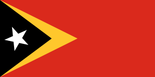
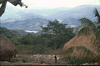
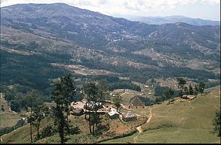
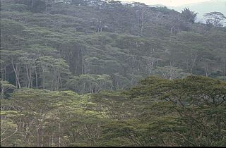
Timor-Leste, also known as East Timor, officially the Democratic Republic of Timor-Leste, is a country in Southeast Asia. It comprises the eastern half of the island of Timor, the exclave of Oecusse on the island's north-western half, and the minor islands of Atauro and Jaco. The western half of the island of Timor is administered by Indonesia. Australia is the country's southern neighbour, separated by the Timor Sea. The country's size is 14,950 square kilometres (5,770 sq mi). Dili, on the north coast of Timor, is its capital and largest city.

<span class="mw-page-title-main">Mambai language (Timor)</span> Austronesian language spoken in East Timor

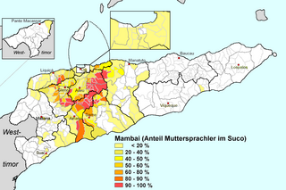
Mambai, also called Mambae or Manbae, is a language spoken by the Mambai people, the second largest ethnic group in the island country of East Timor.

<span class="mw-page-title-main">Bay of Dili</span> Bay in East Timor

The Bay of Dili is a bay on the north coast of East Timor adjacent to Dili, its capital city. The bay forms part of Ombai Strait, which separates the Alor Archipelago from the islands of Wetar, Atauro, and Timor in the Lesser Sunda Islands.

References

Notes

  1. "Sub-national HDI - Area Database - Global Data Lab". hdi.globaldatalab.org. Retrieved 13 September 2018.
  2. "2015 Timor-Leste Census". Statistics Timor-Leste.
  3. 1 2 3 Hull, Geoffrey (June 2006). "The placenames of East Timor" (PDF). Placenames Australia: Newsletter of the Australian National Placenames Survey: 6–7. Archived from the original (PDF) on 14 February 2017. Retrieved 4 June 2018.
  4. 1 2 "Perfil: 2. Toponímia" [Profile: 2. Toponymy]. Dili Municipality (in Tetum). Archived from the original on 17 July 2022. Retrieved 18 July 2022.
  5. Timor-Leste Population and Housing Census - Data Sheet (PDF), Dili: General Directorate of Statistics, 2015, archived from the original (PDF) on 9 July 2022, retrieved 18 April 2022
  6. The Project for Study on Dili Urban Master Plan in the Democratic Republic of Timor-Leste Final Report Part I: Current Conditions (PDF) (Report). Japan International Cooperation Agency (JICA). October 2016. EI JR 16-132. Retrieved 13 April 2022.
  7. Piedade da Freitas, Domingos (9 March 2022). "Governo nomeia Domingos Soares para Administrador Municipal de Ataúro" [Government appoints Domingos Soares as Municipal Administrator of Atauro] (in Portuguese). Tatoli. Archived from the original on 7 July 2022. Retrieved 28 April 2022.
  8. "Governo timorense nomeia primeiro administrador do novo município de Ataúro" [Timorese government appoints first administrator of the new municipality of Ataúro]. RTP Notícias (in Portuguese). 9 March 2022. Retrieved 28 April 2022.
  9. Gunn, Geoffrey C (2011). Historical Dictionary of East Timor. Lanham, Maryland: Scarecrow Press. p. 73. ISBN   9780810867543.

Bibliography

Commons-logo.svg Media related to Dili (Municipality) at Wikimedia Commons