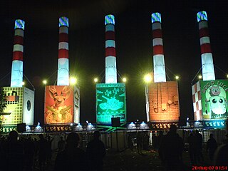
A Campingflight to Lowlands Paradise (Lowlands), is an annual three-day music and performing arts festival, held in the Netherlands. The festival is held 68 kilometres (42 mi) east of Amsterdam in Biddinghuizen, at Spijk en Bremerberg, which is adjacent to Walibi Holland.

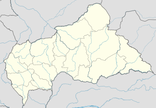
Bambari is a town in the Central African Republic, lying on the Ouaka River. It has a population of 41,356 and is the capital of Ouaka prefecture. Bambari is an important market town and is home to Bambari Airport, and the Roman Catholic Diocese of Bambari.

Märkisches Museum is a Berlin U-Bahn station located on the U 2 in the Mitte district. Since 1935 it has been named after the nearby Märkisches Museum, the municipal museum of the history of Berlin and the Mark Brandenburg.

Adamov is a very small village in the Central Bohemian Region of the Czech Republic. It is located 7 km (4 mi) south of Čáslav and has a population of 114 (2006).

The Autovía A-35 is a highway in the province of Valencia, Spain.
Księginice is a village in the administrative district of Gmina Lubin, within Lubin County, Lower Silesian Voivodeship, in south-western Poland. Prior to 1945 it was in Germany.

Łazy Małe is a village in the administrative district of Gmina Krośnice, within Milicz County, Lower Silesian Voivodeship, in south-western Poland. Prior to 1945 it was in Germany.
Keyhole Glacier is a glacier located in the central Baffin Mountains of northeastern Baffin Island, Nunavut, Canada.
Wybranowo is a village in the administrative district of Gmina Janowiec Wielkopolski, within Żnin County, Kuyavian-Pomeranian Voivodeship, in north-central Poland.
Skiwy Duże is a village in the administrative district of Gmina Siemiatycze, within Siemiatycze County, Podlaskie Voivodeship, in north-eastern Poland.

Wielgomłyny-Kolonia is a village in the administrative district of Gmina Wielgomłyny, within Radomsko County, Łódź Voivodeship, in central Poland. It lies approximately 23 km (14 mi) east of Radomsko and 88 km (55 mi) south of the regional capital Łódź.
Czerniec is a village in the administrative district of Gmina Łącko, within Nowy Sącz County, Lesser Poland Voivodeship, in southern Poland.
Mysławczyce is a village in the administrative district of Gmina Proszowice, within Proszowice County, Lesser Poland Voivodeship, in southern Poland.

Marianów is a village in the administrative district of Gmina Działoszyce, within Pińczów County, Świętokrzyskie Voivodeship, in south-central Poland. It lies approximately 6 kilometres (4 mi) north-east of Działoszyce, 18 km (11 mi) south-west of Pińczów, and 56 km (35 mi) south of the regional capital Kielce.
Lisice-Folwark is a village in the administrative district of Gmina Gozdowo, within Sierpc County, Masovian Voivodeship, in east-central Poland.
Modrzerzewo is a village in the administrative district of Gmina Kleczew, within Konin County, Greater Poland Voivodeship, in west-central Poland.

Marianka is a village in the administrative district of Gmina Brody, within Żary County, Lubusz Voivodeship, in western Poland, close to the German border. It lies approximately 5 kilometres (3 mi) south-west of Brody, 32 km (20 mi) north-west of Żary, and 57 km (35 mi) west of Zielona Góra.
Pupki is a village in the administrative district of Gmina Łukta, within Ostróda County, Warmian-Masurian Voivodeship, in northern Poland.
Struhařov is a municipality and village in Benešov District in the Central Bohemian Region of the Czech Republic.
Rivand Rural District is a rural district (dehestan) in the Central District of Nishapur County, Razavi Khorasan Province, Iran. At the 2006 census, its population was 12,619, in 3,301 families. The rural district has 59 villages.


