
Leavenworth is a city in Chelan County, Washington, United States. It is part of the Wenatchee−East Wenatchee Metropolitan Statistical Area. The population was 2,263 at the 2020 census. The entire town center is modeled on a German Bavarian village as part of a civic initiative that began in the 1960s. The area is a major, four-season tourist destination with festivals nearly every month and a multitude of events year round.
The Chiwaukum Mountains are a north–south mountain range in central Washington, United States. They stretch from Snowgrass Mountain at 47°41′N120°56′W, to 47°45′N120°54′W.
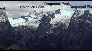
The Stuart Range is a mountain range in central Washington, United States. The range lies within the eastern extent of the Cascade Range immediately southwest of Leavenworth and runs east–west. The western peaks make up a single sharp ridge. The eastern half of the range splits into two parallel ridges, the northern of which is known as the Enchantment Peaks. Between these ridges lies the Enchantment Basin, which holds the dozens of tarns known as the Enchantment Lakes. Collectively, the basin and the encircling eastern peaks of the Stuart Range make up The Enchantments, a well-known backpacking destination. The south face of the Stuart Range falls off steeply to Ingalls Creek, beyond which rise the roughly parallel Wenatchee Mountains.

The Alpine Lakes Wilderness is a large wilderness area spanning the Central Cascades of Washington state in the United States. The wilderness is located in parts of Wenatchee National Forest and Snoqualmie National Forest, and is approximately bounded by Interstate 90 and Snoqualmie Pass to the south and U.S. Route 2 and Stevens Pass to the north. The Alpine Lakes is the largest wilderness area near the population centers of Puget Sound, counted at 414,161 acres (167,605 ha) following the 2014 expansion.

Mount Triumph is a summit in the North Cascades range of Washington state. Located approximately 5.5 miles (8.9 km) west-northwest of the town of Newhalem, it was named by Lage Wernstedt, a surveyor with the U.S. Forest Service. A significant peak in North Cascades National Park, Mount Triumph is one of its "outstanding sights" and is well known among regional climbers for its lack of easy climbing routes to the summit. Despite its moderate elevation, its local relief is dramatic. With the terrain deeply dissected by the valleys of Bacon Creek on the west and Goodell Creek on the east, it rises 1 mile (1.6 km) in less than 2 miles (3.2 km) on the latter side.

Icicle Creek is a non navigable stream in the U.S. state of Washington. It originates at Josephine Lake near the crest of the Cascade Range and flows generally east to join the Wenatchee River near Leavenworth. Icicle Creek's drainage basin is mountainous and mostly undeveloped land within the Wenatchee National Forest and the Alpine Lakes Wilderness. The final 6 miles (10 km) of the creek are moderately developed with scattered homes and pasture, a golf course, children's camp, a small housing development called Icicle Island Club, and the Leavenworth National Fish Hatchery. Some water is diverted from the creek for municipal use by the City of Leavenworth at Icicle Creek river mile 5.6. Near Leavenworth, the wheelchair-accessible Icicle Creek Nature Trail, a National Recreation Trail designated in 2005, runs 1.0 mile (1.6 km) along a historic creek channel.

Snowgrass Mountain is a 7,999-foot (2,438-metre) mountain summit located in Chelan County of Washington state. Snowgrass Mountain is situated northeast of Frosty Pass and within the Alpine Lakes Wilderness. Snowgrass Mountain is the second-highest peak in the Chiwaukum Mountains which are a subrange of the Cascade Range. The nearest higher neighbor is Big Chiwaukum, 1.23 mi (1.98 km) to the north. Precipitation runoff from Snowgrass drains into tributaries of the Wenatchee River.

Big Chiwaukum is a prominent 8,098-foot (2,468-metre) mountain in Chelan County, Washington, United States. Big Chiwaukum is located northeast of Frosty Pass, and within the Alpine Lakes Wilderness. Big Chiwaukum is the highest peak in the Chiwaukum Mountains, a subset of the Cascade Range. The nearest higher peak is Cashmere Mountain, 10.35 mi (16.66 km) to the south-southeast. Precipitation runoff from Big Chiwaukum drains into tributaries of the Wenatchee River. In the Wenatchee dialect, Chiwaukum means many little creeks running into one big one.

Cape Horn is a 7,316-foot (2,230-metre) mountain summit located in Chelan County of Washington state. Cape Horn is situated 12 mi (19 km) west-northwest of Leavenworth, within the Alpine Lakes Wilderness, on land managed by the Okanogan–Wenatchee National Forest. Cape Horn is part of the Chiwaukum Mountains, a subset of the Cascade Range. The nearest higher neighbor is Ladies Peak, 0.9 mi (1.4 km) to the northwest, and Grindstone Mountain is set 1.4 mi (2.3 km) to the south. Precipitation runoff from Cape Horn drains west to Icicle Creek, whereas the east slopes drain into Chiwaukum Creek, and both are tributaries of the Wenatchee River. Although modest in elevation, relief is significant since this peak rises over 4,300 feet above Icicle Creek Valley in approximately two miles. This mountain was named by Albert Hale Sylvester in 1909 for its sharp profile.
Ladies Peak is a 7,708-foot (2,349-metre) mountain summit located in Chelan County of Washington state. Ladies Peak is situated 13 mi (21 km) west-northwest of Leavenworth, within the Alpine Lakes Wilderness, on land managed by the Okanogan–Wenatchee National Forest. Ladies Peak is part of the Chiwaukum Mountains, a subset of the Cascade Range. Its nearest higher neighbor is Snowgrass Mountain, 1.27 mi (2.04 km) to the north, and Cape Horn is set 0.9 mi (1.4 km) to the southeast. Precipitation runoff from Ladies Peak drains west to Icicle Creek, whereas the east slopes drain into Chiwaukum Creek, and both are tributaries of the Wenatchee River. Although modest in elevation, relief is significant since this peak rises over 4,700 feet above Icicle Creek Valley in approximately two miles. This unofficially named peak is named in association with the nearby officially named Ladies Pass, which like many geographical features in this region was named by Albert Hale Sylvester.

Big Lou is a 7,780+ ft mountain summit located in Chelan County of Washington state. It is situated 8.5 mi (13.7 km) west-northwest of Leavenworth, on the boundary of the Alpine Lakes Wilderness, and on land managed by the Okanogan–Wenatchee National Forest. Big Lou is the highest point on Icicle Ridge, and is the third-highest peak in the Chiwaukum Mountains, a subset of the Cascade Range. Its nearest higher neighbor is Snowgrass Mountain, 5 mi (8.0 km) to the northwest, and slightly lower Big Jim Mountain is set 1.75 mi (2.82 km) to the north-northeast. Precipitation runoff from Big Lou drains into Icicle Creek and other tributaries of the Wenatchee River. Although modest in elevation, relief is significant since Big Lou rises 5,200 feet above Icicle Creek Valley in approximately two miles. Big Lou is named for mountaineer Lou Whittaker, the twin brother of Jim Whittaker, the first American to summit Mount Everest.
Lake Alice is a freshwater lakes located on the north slope of the Grindstone Mountain, in Chelan County, Washington. The lake is a popular area for hiking, swimming, and fishing. Self-issued Alpine Lake Wilderness permit required for transit within the Lake Alice area.
Lake Sylvester is a freshwater lake located on the north slope of the Grindstone Mountain, in Chelan County, Washington. The lake is a popular area for hiking, swimming, and fishing. Lake Sylvester is located approximately 15 miles west of the city of Leavenworth and access is obtained by Chatter Creek Trail #1580. Self-issued Alpine Lake Wilderness permit required for transit within the Grindstone Mountain area.
Lower Florence Lake is a freshwater lake located on the west skirt of Ladies Peak and Cape Horn, and North of Grindstone Mountain, in Chelan County, Washington. The lake is a popular area for hiking, swimming, and fishing cutthroat trout. Lower Florence Lake is located further down the slope from Upper Florence Lake, approximately 15 miles west of the city of Leavenworth. Self-issued Alpine Lake Wilderness permit is required for transit within the Lake Alice area.

Upper Florence Lake is a freshwater lake located on the west skirt of Ladies Peak and Cape Horn, and North of Grindstone Mountain, in Chelan County, Washington. The lake is a popular area for hiking, swimming, and fishing, especially for rainbow trout. Lower Florence Lake is located further down the slope of Mary Pass from Upper Florence Lake, approximately 15 miles west of the city of Leavenworth. Self-issued Alpine Lake Wilderness permit required for transit within the Lake Alice area.
Lake Augusta is a freshwater lake located on the southwest skirt of Big Jim Mountain, East of Icicle Ridge, in Chelan County, Washington. Because of its close proximity to Icicle Ridge Trail, the lake is a popular area for hiking, swimming, and fishing cutthroat trout. Smaller Lake Ida is a short distance on the opposite side of Icicle Ridge and Big Jim Mountain Lakes or on the northeast slope of the mountain. Lake Augusta is located approximately 15 miles west of the city of Leavenworth. Self-issued Alpine Lake Wilderness permit required for transit within the Lake Augusta area.
Lake Ida is a freshwater lake located along Icicle Ridge, approximately 10 miles west of the city of Leavenworth in Chelan County, Washington. Because of its close proximity to Icicle Ridge Trail, the lake is a popular area for hiking, swimming, and fishing cutthroat trout. Lake Augusta is a short distance on the opposite side of Icicle Ridge. Lake Ida sits on a highly glaciated alpine cirque, surrounded by a coniferous forest primarily larch pines and outflows into Ida Creek, a tributary of Icicle Creek. At least one unrated waterfall is found downstream as Ida Creek runs the south slope of Icicle Ridge. Self-issued Alpine Lake Wilderness permit required for transit within the Lake Ida and Augusta area.

Lake Edna is a freshwater lake located along Icicle Ridge, approximately 10 miles west of the city of Leavenworth in Chelan County, Washington. Because of its close proximity to Icicle Ridge Trail, the lake is a popular area for hiking, swimming, and fishing. Lake Alice is a short distance in a prominent cirque on the opposite side of Icicle Ridge.

Icicle Ridge is a mountain ridge located in the eastern border of the Alpine Lakes Wilderness, in the Washington state, United States. Several trails lead to Icicle Ridge which borders several prominent mountains, peaks, and lakes. Icicle Ridge is located at the western edge of the city of Leavenworth on land managed by the Okanogan–Wenatchee National Forest.
Josephine Lake is a natural lake and reservoir near Stevens Pass in Chelan County, Washington, United States. At the south skirt of Big Chief Mountain, Josephine Lake is the source of the Icicle Creek. Because Josephine Lake is at the heart of the Alpine Lakes Wilderness, the lake is a popular area for hiking, swimming, and fishing golden trout.

