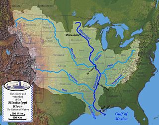
The Mississippi River is the primary river, and second-longest river, of the largest drainage basin in the United States. From its traditional source of Lake Itasca in northern Minnesota, it flows generally south for 2,340 miles (3,766 km) to the Mississippi River Delta in the Gulf of Mexico. With its many tributaries, the Mississippi's watershed drains all or parts of 32 U.S. states and two Canadian provinces between the Rocky and Appalachian mountains. The main stem is entirely within the United States; the total drainage basin is 1,151,000 sq mi (2,980,000 km2), of which only about one percent is in Canada. The Mississippi ranks as the thirteenth-largest river by discharge in the world. The river either borders or passes through the states of Minnesota, Wisconsin, Iowa, Illinois, Missouri, Kentucky, Tennessee, Arkansas, Mississippi, and Louisiana.

The Missouri River is the longest river in the United States. Rising in the eastern Centennial Mountains of the Bitteroot Range of the Rocky Mountains of southwestern Montana, the Missouri flows east and south for 2,341 miles (3,767 km) before entering the Mississippi River north of St. Louis, Missouri. The river drains semi-arid watershed of more than 500,000 square miles (1,300,000 km2), which includes parts of ten U.S. states and two Canadian provinces. Although a tributary of the Mississippi, the Missouri River is slightly longer and carries a comparable volume of water. When combined with the lower Mississippi River, it forms the world's fourth-longest river system.

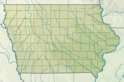
Council Bluffs is a city in and the county seat of Pottawattamie County, Iowa, United States. It is the most populous city in Southwest Iowa, as well as the third largest and a primary city of the Omaha-Council Bluffs Metropolitan Area. It is located on the east bank of the Missouri River, across from Omaha, Nebraska. Until about 1853 Council Bluffs was known as Kanesville. Kanesville was the historic starting point of the Mormon Trail. Kanesville is also the northernmost anchor town of the other emigrant trails because there was a steam-powered boat which ferried the settlers' wagons and cattle across the Missouri River. In 1869, the first transcontinental railroad to California was connected to the existing U.S. rail network at Council Bluffs.
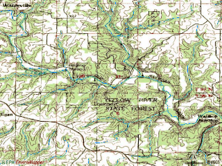
The Maquoketa River is a tributary of the Mississippi River, approximately 150 miles (240 km) long, in northeastern Iowa in the United States. Its watershed covers 1,694 square miles (4,387 km2) within a rural region of rolling hills and farmland southwest of Dubuque. It is not to be confused with the Little Maquoketa River, another distinct direct tributary of the Upper Mississippi River meeting the Big River north of Dubuque. The river and its tributaries mark the border of the Driftless Area of Iowa, with the areas east of it not having been covered by ice during the last ice age. Its name derives from Maquaw-Autaw, which means "Bear River" in Meskwaki.

The Driftless Area, also known as Bluff Country and the Paleozoic Plateau, is a topographical and cultural region in the Midwestern United States that comprises southwestern Wisconsin, southeastern Minnesota, northeastern Iowa, and the extreme northwestern corner of Illinois. The Driftless Area is a USDA Level III Ecoregion: Ecoregion 52. The Driftless Area takes up a large portion of the Upper Midwest forest–savanna transition. The Blufflands refers to the eastern section of the Driftless area in Minnesota, due to the steep bluffs and cliffs around the river valleys. The western half is known as the Rochester Plateau, which is flatter than the Blufflands. The Coulee Region refers to the southwestern part of the Driftless Area in Wisconsin. It is named for its numerous ravines.
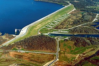
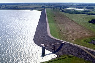
Saylorville Lake is a reservoir on the Des Moines River in Iowa, United States. It is located 11 miles (18 km) upstream from the city of Des Moines, and 214 miles (344 km) from the mouth of the Des Moines River at the Mississippi River. It was constructed as part of a flood control system for the Des Moines River as well as to aid in controlling flood crests on the Mississippi, of which the Des Moines is a tributary. The lake and dam is owned and operated by the U.S. Army Corps of Engineers, Rock Island District.

Lewis and Clark Lake is a 31,400 acre (130 km²) reservoir located on the border of the U.S. states of Nebraska and South Dakota on the Missouri River. The lake is approximately 25 miles (40 km) in length with over 90 miles (140 km) of shoreline and a maximum water depth of 45 feet (14 m). The lake is impounded by Gavins Point Dam and is managed by the U.S. Army Corps of Engineers, Omaha District.

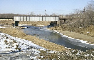
The Raccoon River is a 30.8-mile-long (49.6 km) tributary of the Des Moines River in central Iowa in the United States. As measured using the longest of its three forks, its length increases to 226 miles (364 km). Via the Des Moines River, it is part of the watershed of the Mississippi River. The river runs through an intensely cultivated area of croplands and livestock farming, receiving Tile drainage from slow-draining rich natural bottomland.
Paint Creek is a direct tributary of the Upper Mississippi River, rising in central Allamakee County, Iowa, in and about the city of Waukon. The catchment measures approximately 85.5 square miles (221 km2). It has some still-rural stretches past 9th Street Southwest in Waukon, but most of the actual Waukon portions have been culverted. It joins the Mississippi approximately 6 miles (9.7 km) above Marquette, Iowa in Pool 10, near river mile 641.
The Mississippi River System, also referred to as the Western Rivers, is a mostly riverine network of the United States which includes the Mississippi River and connecting waterways. The Mississippi River is the largest drainage basin in the United States. In the United States, the Mississippi drains about 59% of the country's rivers.
The Upper Mississippi River is the portion of the Mississippi River upstream of St. Louis, Missouri, United States, at the confluence of its main tributary, the Missouri River.

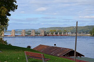
Lock and Dam No. 9 is a lock and dam located near Lynxville, Wisconsin and Harpers Ferry, Iowa on the Upper Mississippi River around river mile 647.9. The lower portion of Pool 9 was formally named Lake Winneshiek. The normal pool elevation behind the dam is 620 feet (189.0 m). It was constructed and placed in operation in July 1937. The site underwent a major rehabilitation from 1989 and 2006. The dam consists of concrete structure 811 feet (247.2 m) long with five roller gates and eight tainter gates. Earth embankment 9,800 feet (2,987.0 m) long with a grouted overflow spillway 1,350 feet (411.5 m) long. The lock is 110 feet (33.5 m) wide by 600 feet (182.9 m) long. Lock and Dam No. 9 is located 12 miles upstream from Prairie du Chien, Wisconsin. The lock and dam are owned and operated by the St. Paul District of the United States Army Corps of Engineers-Mississippi Valley Division.
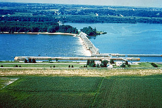
Lock and Dam No. 10 is a lock and dam located in Guttenberg, Iowa on the Upper Mississippi River around river mile 615.0. It was constructed and placed in operation November 1937. The site underwent major rehabilitation 1989—2006. The dam consists of a concrete dam 763 feet (232.6 m) long with four roller gates and eight tainter gates. The earth embankment is 4,223 feet (1,287.2 m) long with a concrete spillway 1,200 feet (365.8 m) long. The lock is 110 feet (33.5 m) wide by 600 feet (182.9 m) long. The lock and dam are owned and operated by the St. Paul District of the United States Army Corps of Engineers-Mississippi Valley Division.

General Zebulon Pike Lock and Dam No. 11 is a lock and dam located between Dubuque, Iowa, and rural Grant County, Wisconsin, on the Upper Mississippi River.

Lock and Dam No. 12 is a lock and dam located on the Upper Mississippi River at Bellevue, Iowa, United States. The movable portion of the dam starts at the locks adjacent to the Iowa shore and is 849 feet (258.8 m) long, consisting of seven tainter gates and three roller gates. It connects to a 200-foot (61.0 m) storage yard and continues toward the Illinois shore with a 2,750-foot (838.2 m) non-submersible dike, a 1,200-foot (365.8 m) submersible dike and a 3,130-foot (954.0 m) non-submersible dike. The non-submersible sections are separated from the submersible section with two 120-foot (36.6 m) transitional dikes. The main lock is 110 feet (33.5 m) wide by 600 feet (182.9 m) long. There is also an incomplete auxiliary lock. In 2004, the facility was listed in the National Register of Historic Places as Lock and Dam No. 12 Historic District, #04000172 covering 1,017 acres (4.1 km2), 1 building, 3 structures, and 4 objects.

Lock and Dam No. 14 is a lock and dam located near LeClaire, Iowa on the Upper Mississippi River above Davenport, Iowa and Moline, Illinois. The movable portion of the dam is 1,343 feet (409.3 m) long and consists of 13 tainter gates and 4 roller gates. Connected to it is a 1,127 feet (343.5 m) long non-submersible rock fill dike which extends to the Illinois side. The main lock is 110 feet (33.5 m) wide by 600 feet (182.9 m) long. The site on the National Register of Historic Places as the Lock and Dam No. 14 Historic District (#04000174) listed in 2004 consisting of 3,043 acres (12.3 km2), 1 building, 6 structures, and 2 objects. It was completed in two phases, the first as part of the six foot channel project from 1921 to 1924, which included a lock and canal bypassing a hazardous rapids. The second phase was part of the nine foot channel project from 1935 to 1939 and included the main dam and the current main lock.
Lock and Dam No. 16 is a lock and dam located near Muscatine, Iowa on the Upper Mississippi River around river mile 457.2. The movable portion of the dam is 1,315 feet (400.8 m) long and consists of 4 roller gates and 15 Tainter gates. The lock is 110 feet (33.5 m) wide by 600 feet (182.9 m) long with a maximum lift of 9 feet (2.7m) In 2004, the facility was listed in the National Register of Historic Places as Lock and Dam No. 16 Historic District, #04000176 covering 1,024 acres (4.1 km2), 1 building, 5 structures, and 2 objects.

Lock and Dam No. 19 is a lock and dam located on the Upper Mississippi River near Keokuk, Iowa. In 1978, the Keokuk Lock and Dam was listed in the National Register of Historic Places, #78001234. In 2004, the facility was listed in the National Register of Historic Places as Lock and Dam No. 19 Historic District, #04000179 covering 1,605 acres (650 ha), 7 buildings, 12 structures, 1 object. The lock is owned and operated by the U.S. Army Corps of Engineers. The dam is owned and operated by Ameren Missouri.
Lake Bardwell is a lake in Ellis County, Texas. The lake was constructed by the United States Army Corps of Engineers in 1965. Lake Bardwell is not used for military operations, and is accessible to the public for recreational purposes; it has seven facilities, but the state public ramp is closed.
Blackhawk Park is a park in Vernon County, Wisconsin within the Driftless Area along the Mississippi River. The park features views of steep limestone bluffs and the river valleys. Wildlife viewing is a popular activity, including the variety of birds which inhabit or migrate through the park. Hiking trails, boat launch facilities, and camping are available. The park is owned and managed by the U.S. Army Corps of Engineers as a recreation area within Pool 9. The park is surrounded by the Upper Mississippi River National Wildlife and Fish Refuge.