
West Logan is a town along the Guyandotte River in Logan County, West Virginia, United States. The population was 400 at the 2020 census. For unknown reasons, some sources report West Logan to lay west of the county seat at Logan, attributing to this fact the name.
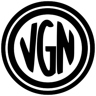
The Virginian Railway was a Class I railroad located in Virginia and West Virginia in the United States. The VGN was created to transport high quality "smokeless" bituminous coal from southern West Virginia to port at Hampton Roads.

The Guyandotte River is a tributary of the Ohio River, approximately 166 mi (267 km) long, in southwestern West Virginia in the United States. It was named after the French term for the Wendat Native Americans. It drains an area of the unglaciated Allegheny Plateau south of the Ohio between the watersheds of the Kanawha River to the northeast and Twelvepole Creek and the Big Sandy River to the southwest. Via the Ohio River, it is part of the Mississippi River watershed.

The Norfolk and Western Railway, commonly called the N&W, was a US class I railroad, formed by more than 200 railroad mergers between 1838 and 1982. It was headquartered in Roanoke, Virginia, for most of its existence. Its motto was "Precision Transportation"; it had a variety of nicknames, including "King Coal" and "British Railway of America". In 1986, N&W merged with Southern Railway to form today's Norfolk Southern Railway.
East Lynn is an unincorporated community in Wayne County, West Virginia, United States, located along the banks of Twelvepole Creek, approximately eight miles south of the county seat, Wayne. It was also known as Mouth of Little Lynn. East Lynn is a part of the Huntington-Ashland Metropolitan Statistical Area (MSA). As of the 2010 census, the MSA had a population of 287,702. New definitions from February 28, 2013 placed the population at 363,000.

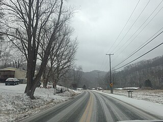
Baber is an unincorporated community at the mouth of Limestone Creek along the Guyandotte River situated between the communities of Daisy and Big Creek in northern Logan County, West Virginia, United States. Baber is accessed by West Virginia Route 10 and CSX Railroad.
Dunlow is an unincorporated community in southern Wayne County, West Virginia, United States, on Twelvepole Creek. It was laid out as a railroad town along the Ohio Extension of the Norfolk and Western Railway in 1892, and was incorporated the same year. The area had plentiful coal deposits that were expected to be exploited. The town became the headquarters of the Guyandotte Coal Land Association, which administered land transactions for coal-related businesses.
The Winding Gulf Coalfield is located in western Raleigh County and eastern Wyoming County, in southern West Virginia. It is named after the Winding Gulf stream, a tributary of the Guyandotte River. In the early 20th century, it was promoted as the "Billion Dollar Coalfield".

U.S. Route 460 (US 460) in Virginia runs east-west through the southern part of the Commonwealth. The road has two separate pieces in Virginia, joined by a relatively short section in West Virginia. Most of US 460 is a four-lane divided highway and is a major artery in the southern third of the state. From Petersburg to Suffolk, US 460 is a four-lane non-divided highway. It is a popular alternative to Interstate 64 (I-64) when going from Richmond and other points in central Virginia to the Currituck Sound and Outer Banks of North Carolina, avoiding the congestion and tunnels of the more northerly I-64 corridor. The road passes through several small towns that built up at stops along the railroad line.
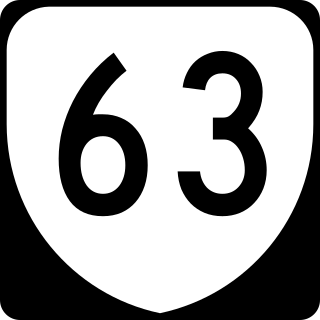
State Route 63 is a primary state highway in the U.S. state of Virginia. The state highway runs 39.28 miles (63.22 km) from U.S. Route 58 Alternate in St. Paul north to SR 80 and SR 83 in Haysi.
The Cumberland Valley Subdivision is a railroad line owned and operated by the CSX Railroad in the U.S. states of Kentucky and Virginia. The line runs from Corbin, Kentucky, east to Big Stone Gap, Virginia, along a former Louisville and Nashville Railroad line.
Guyandotte is a historic neighborhood in the city of Huntington, West Virginia, that previously existed as a separate town before annexation was completed by the latter. The neighborhood is home to many historic properties, and was first settled by natives of France at the end of the eighteenth century. Guyandotte was already a thriving town when the state of West Virginia was formed from part of Virginia. Located at the confluence of the Guyandotte River and the Ohio River, it was already a regional trade center with several industries of its own when the Chesapeake and Ohio Railway (C&O) reached its western terminus nearby just across the Guyandotte River in 1873. This event was soon followed by the formation and quick development of the present city of Huntington which was named in honor of the C&O Railway's founder and then principal owner Collis P. Huntington.
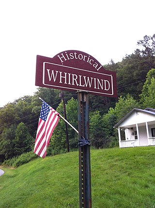
Whirlwind is an unincorporated community on Big Harts Creek in Logan County, West Virginia, United States.
Atenville is an unincorporated community in Lincoln County, West Virginia, United States. It is a residential community located in Harts Creek District and is part of the Harts census-designated place.
Toney is an unincorporated community in Lincoln County, West Virginia, United States. Its post office was established in 1904 by Brad Toney, merchant.

Gill is an unincorporated community and former railroad town in Lincoln County, West Virginia, United States.
The Guyandotte Valley Railroad Company was incorporated by the State of West Virginia on March 1, 1899. Under supervision of the Chesapeake and Ohio Railway, the GVRR constructed 50.2 miles of single track, standard gauge railroad line between Barboursville in Cabell County to Big Creek in Logan County. On October 31, 1903, the C&O acquired its franchise, rights, and property.

Big Harts Creek, often shortened to "Harts Creek" or "Big Hart," is a major tributary of the Guyandotte River in Lincoln and Logan counties, West Virginia.
The Princeton–Deepwater District is a rail line in West Virginia that connects Deep Water, West Virginia, on the Kanawha River southwards to Princeton, West Virginia, and beyond to rail lines leading to Virginia. It is known for its rugged terrain and opportunities for rail photography.
The Dunlow Norfolk & Western Railway Depot is a historic railroad depot in the small community of Dunlow, West Virginia, located along the former route of the Norfolk and Western Railway's Ohio Extension line.