
Tobermory is the capital of, and until 1973 the only burgh on, the Isle of Mull in the Scottish Inner Hebrides. It is located on the east coast of Mishnish, the most northerly part of the island, near the northern entrance of the Sound of Mull. The village was founded as a fishing port in 1788; its layout was based on the designs of Dumfriesshire engineer Thomas Telford. It has a current population of about 1,000.
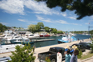
Tobermory is a small community located at the northern tip of the Bruce Peninsula, in the traditional territory of the Saugeen Ojibway Nation. Until European colonization in the mid-19th century, the Bruce Peninsula was home to the Saugeen Ojibway nations, with their earliest ancestors reaching the area as early as 7,500 years ago. It is part of the municipality of Northern Bruce Peninsula. It is 300 kilometres northwest of Toronto. The closest city to Tobermory is Owen Sound, 100 kilometres south of Tobermory and connected by Highway 6.

The Bruce Peninsula is a peninsula in Ontario, Canada, that divides Georgian Bay of Lake Huron from the lake's main basin. The peninsula extends roughly northwestwards from the rest of Southwestern Ontario, pointing towards Manitoulin Island, with which it forms the widest strait joining Georgian Bay to the rest of Lake Huron. The Bruce Peninsula contains part of the geological formation known as the Niagara Escarpment.

Fathom Five National Marine Park is a National Marine Conservation Area in the Georgian Bay part of Lake Huron, Ontario, Canada, that seeks to protect and display shipwrecks and lighthouses, and conserve freshwater ecosystems. Parks Canada has management plans for the aquatic and terrestrial ecosystems, with a multi-action plan for species that are at risk, including endemic species, the Monarch butterfly, the eastern ribbonsnake, and the eastern whip-poor-will. The aquatic ecosystems in the park are also of particular interest. Many fish, shellfish, amphibians, and eels are an attraction for naturalists in the park. Much of this wildlife is accessible to scuba divers and snorkellers in the park. The many shipwrecks make the park a popular scuba diving destination, and glass bottom boat tours leave Tobermory regularly, allowing tourists to see the shipwrecks without having to get wet. Additionally, there are three main popular hiking trails found within Fathom Five National Marine Park that provides visitors with views of old growth forests and the Georgian Bay. The Saugeen Ojibway Peoples have inhabited the Bruce Peninsula and the area that is now Fathom Five National Marine Park for thousands of years. This land provided for their communities and their people with the plethora of wildlife and plant life. They provide the local knowledge about Lake Huron and its ecological value to the reserve, park, and their overall livelihood. Parks Canada and Saugeen Ojibway People's collaboration is said to yield a benefit to both parties with regard to overall ecosystem knowledge.

Southampton is a community on the shores of Lake Huron in Bruce County, Ontario, Canada. It is close to Port Elgin and is located at the mouth of the Saugeen River in the Saugeen Ojibway Nation Territory. The size of the town is 6.44 square kilometres. The permanent population in 2016 was 3,678, but the summer population is higher since cottagers and campers spend vacation time in the area.

The Gibraltar Point Lighthouse is a lighthouse located on the Toronto Islands in Toronto, Ontario, Canada. Begun in 1808, it is the oldest existing lighthouse on the Great Lakes, and one of Toronto's oldest buildings. The lighthouse is perhaps best known for the demise of its first keeper, German-born John Paul Radelmüller, whose 1815 murder forms the basis of Toronto's most enduring ghost story. Recent research has verified many aspects of the traditional tale of his death and identified the soldiers charged with but ultimately acquitted of the crime.

The Cape San Blas Light is a lighthouse in the state of Florida in the United States. There were four built between 1849 and 1885. It was located at Cape San Blas in the northwestern part of the state. Due to beach erosion and weather damage over the decades, it was moved in 2014 to Port St. Joe. The lighthouse was listed on the National Register of Historic Places in 2015.

A lighthouse keeper or lightkeeper is a person responsible for tending and caring for a lighthouse, particularly the light and lens in the days when oil lamps and clockwork mechanisms were used. Lighthouse keepers were sometimes referred to as "wickies" because of their job trimming the wicks.

Fisgard Lighthouse National Historic Site, on Fisgard Island at the mouth of Esquimalt Harbour in Colwood, British Columbia, is the site of Fisgard Lighthouse, the first lighthouse on the west coast of Canada.

Point Clark is a lakefront cottage community on Lake Huron, in the municipality of Huron-Kinloss, Ontario, Canada. It is approximately 15 kilometres south of Kincardine and 40 kilometres north of Goderich. Main streets include Huron Road and Lake Range Road. Point Clark is served by Highway 21 (Ontario). It is a cottage town, and has a rare Imperial Tower style lighthouse. There is a sandy beach and a small harbour with a boat ramp. There are two streams or rivers that run into Lake Huron around Point Clark: Clark Creek and Pine River. There is a separate harbour in the mouth of the Pine River. Amberley is just outside and to the south of Point Clark and Lucknow is to the south-east of Point Clark.

The Cove Island Light, at Gig Point on the island, is located in Fathom Five National Marine Park, but is not part of the Park. It is situated on the Bruce Peninsula, Ontario Canada. It has been a navigational aid in the narrow channel between Lake Huron and Georgian Bay since 30 October 1858. It was the first of six stone Imperial Towers to be completed; all were illuminated by 1859. Most other lighthouses of the era were built of brick, wood, iron or concrete.

Lion's Head Lighthouse was a lighthouse on Georgian Bay, Ontario, Canada near the village of Lion's Head. A recent lighthouse was a replica built by local high school students. This was destroyed by several storms in the winter of 2019–2020.
For other ships of this name, see Sweepstake (disambiguation)

The Wood Islands Lighthouse is a historic lighthouse built by Donald MacMillan situated on the southeastern shore of Prince Edward Island, located in the community of Wood Islands. The lighthouse is a well-preserved three storey tower with an adjoining 1+1⁄2-storey keeper's residence. The white shingled tower is topped by a red iron lantern, which is enclosed by a white railing on the observation deck. The red roof of the dwelling provides a striking contrast to the white shingled exterior of the dwelling.

The Kincardine Lighthouse is a historic lighthouse located in Kincardine, Ontario, near the mouth of the Penetangore River. Built in 1881, it is 24.4 metres tall and was built above the light keeper's home. The tower is eight sided and sits on a stone foundation. The facility has been renovated and is now the Kincardine Yacht Club and a museum. It is open for tours from July 1 to Labour Day.

The Grand Harbour Lighthouse was a Canadian lighthouse marking the entrance to Grand Harbour, Grand Manan, New Brunswick. It was built and first lit in 1879 and was decommissioned in 1963. It was severely damaged in the Groundhog Day gale of 1976 and destroyed by a gale in November 2013.
The Cape Croker Lighthouse is a lighthouse located on the south-east corner of Neyaashiinigmiing 27 native reserve in Ontario, Canada. It is a part of the Chippewas of Nawash Unceded First Nation.

