
Bareilly is a city in Bareilly district in the Indian state of Uttar Pradesh. It is the capital of Bareilly division and the geographical region of Rohilkhand. The city is 252 kilometres (157 mi) north west of the state capital, Lucknow, and 250 kilometres (155 mi) east of the national capital, New Delhi. It is the eighth largest metropolis in Uttar Pradesh, and the 50th-largest city in India. Bareilly also figured amongst the PM Narendra Modi's ambitious 100 Smart City list in India. It is located on the Ramganga River and is the site of the Ramganga Barrage built for canal irrigation. ' and historically as Sanjashya.
The Bareilly districtpronunciation (help·info) belongs to the state Uttar Pradesh in northern India. Its capital is Bareilly city and it is divided in six administrative division or tehsils: Aonla, Baheri, Bareilly city, Faridpur, Mirganj, and Nawabganj. The Bareilly district is a part of the Bareilly Division and occupies an area of 4120 km2 with a population of 4,448,359 people according to the census of 2011.

Pilibhit is a city and a municipal board of Pilibhit district in the Indian state of Uttar Pradesh. Pilibhit is the north-easternmost district of Bareilly division, situated in the Rohilkhand region of the sub-Himalayan Plateau belt next to foothills of Sivalik Range on the boundary of Nepal, known for the origin of river Gomati and one of the most forest-rich areas in North India. Pilibhit was also known as Bansuri Nagari – the land of flutes, for making and exporting roughly 95 per cent of India's flutes.

Baheri is a tehsil in Bareilly district in the northern Indian state of Uttar Pradesh. It is geographically located near the lower reaches of Gaula river. The Town 300 kilometres (186 mi) north of the state capital, Lucknow, and 300 kilometres (186 mi) east of the national capital, New Delhi.
Rithora is a town and a nagar panchayat in Bareilly Tehsil of Bareilly district in the Indian state of Uttar Pradesh.

Nawabganj is a Nagar palika and an administrative subdivision of Bareilly district in the Indian state of Uttar Pradesh. A Sub Divisional Magistrate (SDM), also called Sub Divisional Officer (SDO), or pargana-adhikari is the head official.

Vengappally is a village in Wayanad district in the state of Kerala, India.
Girdharpur( गिरधरपुर, گردھرپر ) is a village in Bareilly district of the Indian state of Uttar Pradesh. It is 3 kilometers away from State Highway 37 and lies within the coordinates 28°42'51.60"N & 79°27'46"E.
Daiya Bojh is a village situated in the Baheri Mandal of Bareilly District in Uttar Pradesh, India. It is located about 46.65 km from the district headquarters in Bareilly.
Uttar Pradesh State Highway 37 or SH 37 is a State Highway in the state of Uttar Pradesh, India that connects Bareilly to Kichha, running through Baheri.

Nohsa is a census town in Phulwari Sharif, Patna in Bihar state of India. It is a part of Patna urban agglomeration.
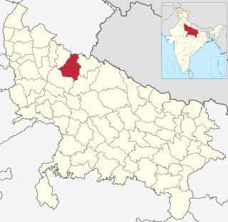
Baheri Assembly constituency is one of the 403 constituencies of the Uttar Pradesh Legislative Assembly, India. It is a part of the Bareilly district and one of the five assembly constituencies in the Pilibhit. First election in this assembly constituency was held in 1957 after the "DPACO (1956)" was passed in 1956. After the "Delimitation of Parliamentary and Assembly Constituencies Order" was passed in 2008, the constituency was assigned identification number 118.
Bareilly Vidhan Sabha Constituency is one of the 403 constituencies of the Uttar Pradesh Legislative Assembly, India. It is a part of the Bareilly district and one of the five assembly constituencies in the Bareilly. First election in this assembly constituency was held in 2012 after the "Delimitation of Parliamentary and Assembly Constituencies Order, 2008" was passed and the constituency was formed in 2008. The constituency is assigned identification number 124. And Baheri town is the largest Tahseel of zila Bareilly, settled with Muslim Majority. Meena Bazar is a famous place in Baheri and known around the other places as a great hub for Ladies' shopping. VVPAT facility with EVMs will be here in the 2017 U.P assembly polls.

Kathgodam railway station is railway station located in Kathgodam town near Haldwani in Nainital district of Uttarakhand State of India.

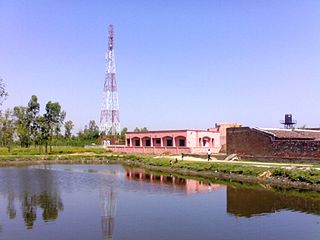
Baheri railway station is a railway station in Bareilly district, Uttar Pradesh. Its code is BHI. It serves Baheri city. The station consists of two platforms. Passenger and Express trains halt here.
Babat is a village in Salarpur block, Budaun district, Uttar Pradesh, India. The Budaun railway station is located at the distance of 10 kilometer from the village. Babat village is administrated by Gram panchayat. Its village code is 128242. According to 2011 Census of India, the total population of the village is 2586, out of 1,387 are males and 1,199 are females.
The Kumaun Express is a passenger train belonging to Indian Railways - North Eastern Railway zone that used to run between Agra Fort railway station and Kathgodam railway station in India. It used to run seven days in a week. Its average speed was 36 km/hr. Later it used to run in Kasganj Junction railway station & Bareilly City railway station when Bareilly to Lalkuan & Agra Fort to Kasganj was being made Broad Gauge from Metre Gauge railway line.
Gauramai is a village in Qadar Chowk Block, Budaun district, Uttar Pradesh, India. Its village code is 128624. The village is administrated by Gram Panchayat. Budaun railway station is 21 km away from the village. According to 2011 Census of India, the total population of the village is 2,845, out of 1,501 are males and 1,344 are females.
Lalei (Hindi:ललेई) is a village and gram panchayat in Salarpur block, Budaun district, Uttar Pradesh, India. Its village code is;128314. The village is located 11 KM north from Budaun railway station. According to 2011 Census of India, the total population of the village is 1486, out of 798 are males and 688 are females.
Kupri is a village and gram panchayat in Jagat block, Budaun district, Uttar Pradesh, India. Its village code is 128441. The village is located 16 KM East from Budaun railway station. According to 2011 Census of India, the total population of the village is 1210, out of 675 are males and 535 are females.
