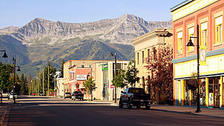
Fernie is a city in the Elk Valley area of the East Kootenay region of southeastern British Columbia, Canada, located on BC Highway 3 on the western approaches to the Crowsnest Pass through the Rocky Mountains. Founded in 1898 and incorporated as the City of Fernie in July 1904, the municipality has a population of over 5,000 with an additional 2,000 outside city limits in communities under the jurisdiction of the Regional District of East Kootenay. A substantial seasonal population swells the city during the winter months.

A snowmobile, also known as a snowmachine, motor sled, motor sledge, skimobile, or snow scooter, is a motorized vehicle designed for winter travel and recreation on snow.

Mount Garibaldi is a dormant stratovolcano in the Garibaldi Ranges of the Pacific Ranges in southwestern British Columbia, Canada. It has a maximum elevation of 2,678 metres and rises above the surrounding landscape on the east side of the Cheakamus River in New Westminster Land District. In addition to the main peak, Mount Garibaldi has two named sub-peaks. Atwell Peak is a sharp, conical peak slightly higher than the more rounded peak of Dalton Dome. Both were volcanically active at different times throughout Mount Garibaldi's eruptive history. The northern and eastern flanks of Mount Garibaldi are obscured by the Garibaldi Névé, a large snowfield containing several radiating glaciers. Flowing from the steep western face of Mount Garibaldi is the Cheekye River, a tributary of the Cheakamus River. Opal Cone on the southeastern flank is a small volcanic cone from which a lengthy lava flow descends. The western face is a landslide feature that formed in a series of collapses between 12,800 and 11,500 years ago. These collapses resulted in the formation of a large debris flow deposit that fans out into the Squamish Valley.

The Wallowa Mountains are a mountain range located in the Columbia Plateau of northeastern Oregon in the United States. The range runs approximately 40 miles (64 km) northwest to southeast in southwestern Wallowa County and eastern Union County between the Blue Mountains to the west and the Snake River to the east. The range is sometimes considered to be an eastern spur of the Blue Mountains, and it is known as the "Alps of Oregon". Much of the range is designated as the Eagle Cap Wilderness, part of the Wallowa–Whitman National Forest.

Loveland Pass is a high mountain pass in north-central Colorado, at an elevation of 11,990 feet (3,655 m) above sea level in the Rocky Mountains of the Western United States.

Kokanee Lake is one of over 30 alpine lakes located in British Columbia's Kokanee Glacier Provincial Park. The lake is approximately 1,200 metres (3,900 ft) long and 400 metres (1,300 ft) wide, at an elevation of 1,981 metres (6,499 ft) and located at the head of Kokanee Creek. It is fed by the Kokanee Glacier and is the headwater of Kokanee Creek. Access is possible via the Gibson Lake trailhead, from which Kokanee Lake is a four-kilometre (2.5 mi) hike. Fishing is permitted and the lake is usually stocked with cutthroat trout.

Kokanee Glacier Provincial Park is one of the oldest provincial parks in British Columbia, established in 1922. The park has an area of 320.35 km2 (123.69 sq mi) and is located in the Selkirk Mountains in the West Kootenays region of BC. The park has three glaciers that feed over 30 alpine lakes which are the headwaters of many creeks.

Mount Tom is a large and prominent peak near the city of Bishop in Inyo County of eastern California. It is in the Sierra Nevada and east of the Sierra Crest. The mountain is also in the John Muir Wilderness.
Highmarking or High-Marking is a popular activity performed by snowmobilers in mountainous terrain, where the snowmobile operator tries to ride as far up a steep mountain slope as possible, then turn around and come back down the hill without getting stuck, rolling the snowmobile or losing power.

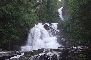
Bijoux Falls Provincial Park is a provincial park in British Columbia, Canada. The park is located north of the city of Prince George on BC Highway 97 on the southern approach to the summit of the Pine Pass through the Rocky Mountains. The park was established in 1956 primarily to serve as a rest stop and to provide information about the park system in BC to travellers. The park is named for Bijoux Falls, a 40-metre-high (130 ft) cascading waterfall that is the central feature of the park.

Kakwa Provincial Park and Protected Area is a 170,890 ha provincial park in northeastern British Columbia, Canada. The park preserves the southernmost portion of the Hart Ranges and the northernmost portion of the Continental Ranges. The park also preserves significant marine fossil deposits located in the region.

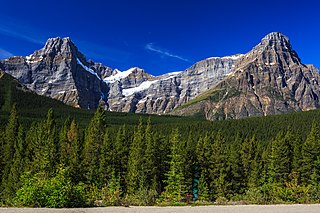
Howse Peak is the highest mountain in the Waputik Mountains, a subrange of the Canadian Rockies. It is located 5 km (3 mi) west of the Icefields Parkway, above Chephren Lake, on the continental divide between Alberta and British Columbia. At 3,295 m (10,810 ft), it is the 46th highest peak in Alberta, and the 59th highest in British Columbia.
The Pine Pass, in the Hart Ranges of the Northern Rockies of British Columbia, connects the Peace Country of the province's Northeastern Interior. Highway 97 and the Canadian National Railway (CNR) traverse this mountain pass, which is the location of the Bijoux Falls Provincial Park, the Pine Le Moray Provincial Park, and the Powder King Mountain Resort at Azouzetta Lake.
The Misinchinka River is a river in the north-central Interior of British Columbia, Canada, rising in the northern Hart Ranges to flow northwest to join the Parsnip River just before that river's estuary into the Parsnip Reach of Lake Williston, part of the Peace-Mackenzie Rivers drainage.
Events from the year 2010 in Canada.

The Dawson Creek Rage were a Tier II Junior A ice hockey team, based out of Dawson Creek, British Columbia. Formed in 2010, they played in the North American Hockey League's West Division for two seasons. Their 2010–11 season included a six-game win streak, though they ended the season fifth in a six team division with 24 wins in 58 games. The 2011–12 season included an 11-game homestand in which they only won 2 games, and a last place finish with only 12 wins overall. With losing records in both seasons, the team did not make the playoffs in either season. Despite attracting better than average attendance for a NAHL team, high travelling and operating costs resulted in the team ceasing operations in April 2012.

Tyson Barrie is a Canadian professional ice hockey defenceman who currently plays for the Calgary Flames of the National Hockey League (NHL). He has previously played for the Colorado Avalanche, Toronto Maple Leafs, Edmonton Oilers and Nashville Predators. He was drafted by the Avalanche in the third round, 64th overall, of the 2009 NHL Entry Draft.

Scotch Bonnet Mountain is a 10,385-foot (3,165-metre) summit in Park County, Montana, United States.

Crown Butte is a 10,225-foot (3,117-metre) summit in Park County, Montana, United States.


