
Billy Goat Hill, San Francisco is the easternmost peak in the San Miguel Range located in the Glen Park neighborhood in San Francisco, California.
Billy Goat Hill, San Francisco is the easternmost peak in the San Miguel Range located in the Glen Park neighborhood in San Francisco, California.

The Hill is located on the corner of 30th and Laidley streets, near the outskirts of Noe Valley, where wooden stairs and a steep dirt path lead to lookout point of about 500 feet, which offers excellent views of the Bay Bridge and downtown San Francisco. [1]
The top of the rocky hill has two large old eucalyptus trees where a wooden rope swing once stood, but after recent renovations by the San Francisco Recreation and Parks Department, the swing has been taken down. The $150,000 renovation project included the opening of Beacon Trail, a path connecting Billy Goat Hill to Walter Haas Playground, in July 2016. [2]
Billy Goat Hill is a destination for tourists and locals to take-in views of the city. There is an array of wildflowers and greenery, including California saxifrage, which can only be found in two other areas of San Francisco. [3]
The Hill is what remains of a quarry that was mined by the Gray Brothers in the late 1800s and early 1900s. [4] Once the Quarry closed, the Hill became a neighborhood common space, but also a dumping ground for locals. It was not until 1975 when it officially became a city park; only a mere 3.5 acres, the park also includes a small network of trails, which has now expanded to The Walter Haas Playground. [5]
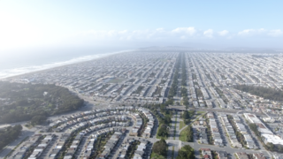
The Sunset District is a neighborhood located in the southwest quadrant of San Francisco, California, United States.

Point Pinole Regional Shoreline is a regional park on the shores of the San Pablo Bay, California, in the United States. It is approximately 2,315 acres (9.37 km2) in area, and is operated by the East Bay Regional Park District. It includes the Dotson Family Marsh and the Point Pinole Lagoon and hosts the North Richmond Shoreline Festival.

Benicia State Recreation Area is a state park unit of California, United States, protecting tidal wetland. It is located in the Solano County city of Benicia, 2 miles (3.2 km) west of downtown Benicia and borders Vallejo's Glen Cove neighborhood. The park covers 447 acres (181 ha) of marsh, grassy hillsides and rocky beaches along the narrowest portion of the Carquinez Strait. Southampton Creek and the tidal marsh front Southampton Bay, where the combined waters of the Sacramento and San Joaquin Rivers approach San Pablo Bay, the northern portion of San Francisco Bay.

Bernal Heights is a residential neighborhood in southeastern San Francisco, California. The prominent Bernal Heights hill overlooks the San Francisco skyline and features a microwave transmission tower. The nearby Sutro Tower can be seen from the Bernal Heights neighborhood.

Mission Dolores Park, often abbreviated to Dolores Park, is a city park in San Francisco, California. It is located two blocks south of Mission Dolores at the western edge of the Mission District.

John McLaren Park is a park in southeastern San Francisco. At 312.54 acres (126.48 ha), McLaren Park is the third largest park in San Francisco by area, after Golden Gate Park and the Presidio. The park is surrounded mostly by the Excelsior, Crocker-Amazon, Visitacion Valley, Portola and University Mound neighborhoods.
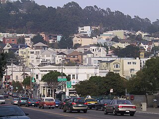
Glen Park is a residential neighborhood in San Francisco, California, located south of Twin Peaks and adjacent to Glen Canyon Park.
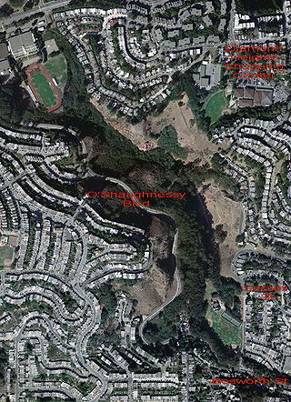
Glen Canyon Park is a city park in San Francisco, California. It occupies about 70 acres (28 ha) along a deep canyon adjacent to the Glen Park, Diamond Heights, and Miraloma Park neighborhoods. O'Shaughnessy Hollow is a rugged, undeveloped 3.6 acres (1.5 ha) tract of parkland that lies immediately to the west and may be considered an extension of Glen Canyon Park.

Crocker-Amazon is a neighborhood in San Francisco that borders the Excelsior District. Crocker-Amazon covers the area south of Mission Street and Geneva Avenue, extending toward suburban Daly City. The neighborhood is adjacent to Crocker-Amazon Park, named after the Charles Crocker land holdings that once made up the area, and Amazon Avenue in the Excelsior. The winding streets of the neighborhood straddle the border between San Francisco and Daly City and largely blend in with the adjacent Daly City neighborhoods of Crocker and Southern Hills.

Crissy Field is a public recreation area on the northern shore of the San Francisco Peninsula in California, United States, located just east of the Golden Gate Bridge. It includes restored tidal marsh and beaches.

Diamond Heights is a neighborhood in central San Francisco, California, roughly bordered by Diamond Heights Boulevard and Noe Valley to the north and east and Glen Canyon Park to the south and west. It is built on three hills: Red Rock Heights on the northwest, Gold Mine Hill in center, and Fairmount Heights on the southeast.

Portsmouth Square, formerly known as Portsmouth Plaza, and originally known as Plaza de Yerba Buena, or simply La Plaza, is a one-block plaza in Chinatown, San Francisco, California. Portsmouth Square is the first park in San Francisco predating both Washington Square (1847) and Union Square (1850). Established in the early 19th century, during the period of Mexican California, the plaza was renamed following the U.S. Conquest of California in honor of the USS Portsmouth, the American ship which captured the city. It is bounded by Kearny Street on the east, Washington Street on the north, Clay Street on the south, and Walter Lum Place on the west.

Telegraph Hill is a hill and surrounding neighborhood in San Francisco, California. It is one of San Francisco's 44 hills, and one of its original "Seven Hills".
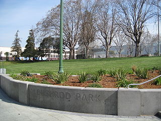
The Bushrod neighborhood in North Oakland, Oakland, California is an area surrounding its namesake park, and bounded by Martin Luther King, Jr. Way to the west, Claremont Avenue to the east, Highway 24 to the south, and the Berkeley border to the north. It borders the neighborhoods of Santa Fe to the west, Fairview Park to the east, and Temescal and Shafter to the south and southeast, respectively. Notable landmarks include the Bushrod Park ballfields and the former Bushrod Washington Elementary School, which share adjoining land on a large greenbelt and open space in the heart of the neighborhood.

Garfield Square, also known as Garfield Park, is a 3.46-acre (14,000 m2) city park located in the Mission District of San Francisco, California. It is bounded by 25th Street to the north, 26th Street to the south, Treat Avenue to the west, and Harrison Street to the east and was first opened in 1884. Previously the location of the Recreation Grounds baseball park which was the first professional baseball park in California, dating to 1868.

Corona Heights is a neighborhood in San Francisco, California, just north of Market Street and Eureka Valley. Corona Heights is often considered part of the Castro and Upper Market areas.
The San Francisco Recreation & Parks Department is the city agency responsible for governing and maintaining all city-owned parks and recreational facilities in San Francisco, California. The Recreation & Parks Department also runs Sharp Park in Pacifica, California and Camp Mather in Tuolumne County, California. Current facilities include 4,113 acres (1,664 ha) of total recreational and open space with 3,400 acres (1,376 ha) of that land within San Francisco. The department runs 179 playgrounds and play areas, 82 recreation centers and clubhouses, nine swimming pools, five golf courses, 151 tennis courts, 72 basketball courts, 59 soccer fields, numerous baseball diamonds, and other sports venues.

Nob Hill is a neighborhood of San Francisco, California, United States that is known for its numerous luxury hotels and historic mansions. Nob Hill has historically served as a center of San Francisco's upper class. Nob Hill is among the highest-income neighborhoods in the United States, as well as one of the most desirable and expensive real estate markets in the country.

Boeddeker Park, more formally known as Father Alfred E. Boeddeker Park, is an urban park in the Tenderloin neighborhood of San Francisco. This 1-acre park was renovated and reopened in 2014, especially intended to serve the needs of people in the surrounding neighborhood who experience amongst the highest levels of poverty in the city. The park was completed with a large mural, Everyone Deserves a Home, on the building above the park in 2016.

Bowne Park is a 11.79-acre (4.77 ha) park in Broadway–Flushing, Queens, New York, east of downtown Flushing. It is bordered by 29th Avenue on the north, 32nd Avenue on the south, 155th Street on the west, and 159th Street on the east. The park consists of a playground, basketball courts, bocce court, and a kettle pond. The area immediately surrounding the park, developed in the late 19th and early 20th centuries, was originally also marketed as "Bowne Park" and is part of modern-day Murray Hill and Broadway–Flushing.