Živanice is a village in the Pardubice Region of the Czech Republic. It has 965 inhabitants.
Cózar is a municipality in Ciudad Real, Castile-La Mancha, Spain. It has a population of 1,260.

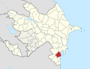
This is a list of the extreme points of Azerbaijan, the points that are farther north, south, east or west than any other location.

Závažná Poruba is a village and municipality in Liptovský Mikuláš District in the Žilina Region of northern Slovakia.

Svilojevo is a village in Serbia. It is situated in the Apatin municipality, in the West Bačka District, Vojvodina province. The population of the village numbering 1,179 people, most of whom are ethnic Hungarians.
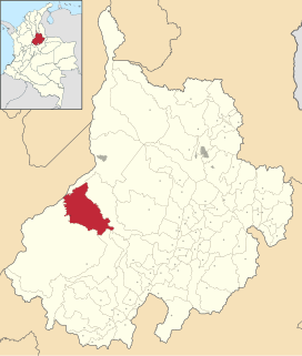
Puerto Parra is a town and municipality in the Santander Department in northeastern Colombia.

Cardiel de los Montes is a municipality located in the province of Toledo, Castile-La Mancha, Spain. According to the 2006 census (INE), the municipality has a population of 256 inhabitants.

Havârna is a commune in Botoșani County, Romania. It is composed of six villages: Balinți, Galbeni, Gârbeni, Havârna, Niculcea and Tătărășeni.

Niedabyl is a village in the administrative district of Gmina Stromiec, within Białobrzegi County, Masovian Voivodeship, in east-central Poland. It lies approximately 2 kilometres (1 mi) north-west of Stromiec, 9 km (6 mi) east of Białobrzegi, and 64 km (40 mi) south of Warsaw.
Meşəkənarı is a village and municipality in the Masally Rayon of Azerbaijan. It has a population of 471.
Həziabad is a village and municipality in the Jalilabad Rayon of Azerbaijan. It has a population of 1,721.

Hưng Yên is a city in Vietnam. It is the provincial capital of Hưng Yên Province and is a third-graded city according to Vietnam's city classification table.

Blučina is a village and municipality (obec) in Brno-Country District in the South Moravian Region of the Czech Republic, some 8 km south of Brno.
Gramatikovo is a village in Malko Tarnovo Municipality, in Burgas Province, in southeastern Bulgaria. It is situated in Strandzha Nature Park.
Paasvere is a village in Laekvere Parish, Lääne-Viru County, in northeastern Estonia.
Nepste is a village in Häädemeeste Parish, Pärnu County in southwestern Estonia.
Nako Island is an island of Greenland. It is located in Baffin Bay in the Upernavik Archipelago.

Moraleja is a municipality located in the province of Cáceres, Extremadura, Spain. It is the most important town in the Sierra de Gata comarca. The Postal Code is 10128.

Sankt Jørgensbjerg is a district of Roskilde on the Danish island of Zealand. Initially a fishing village in its own right with a history dating back to the Viking era, it became part of Roskilde in 1938. Today it has become the most desirable district in the city.