A biome is a community of plants and animals that have common characteristics for the environment they exist in. They can be found over a range of continents. Biomes are distinct biological communities that have formed in response to a shared physical climate. "Biome" is a broader term than "habitat"; any biome can comprise a variety of habitats.

Taiga, also known as boreal forest or snow forest, is a biome characterized by coniferous forests consisting mostly of pines, spruces, and larches.

In geography, the temperate or tepid climates of Earth occur in the middle latitudes, which span between the tropics and the polar regions of Earth. These zones generally have wider temperature ranges throughout the year and more distinct seasonal changes compared to tropical climates, where such variations are often small.

Sodium carbonate, Na2CO3, (also known as washing soda, soda ash and soda crystals) is the inorganic compound with the formula Na2CO3 and its various hydrates. All forms are white, water-soluble salts. All forms have a strongly alkaline taste and give moderately alkaline solutions in water. Historically it was extracted from the ashes of plants growing in sodium-rich soils. Because the ashes of these sodium-rich plants were noticeably different from ashes of wood (once used to produce potash), sodium carbonate became known as "soda ash". It is produced in large quantities from sodium chloride and limestone by the Solvay process.

A Mediterranean climate or dry summer climate is characterized by rainy winters and dry summers, with less than 40 mm of precipitation for at least three summer months. While the climate receives its name from the Mediterranean Basin, these are generally located on the western coasts of continents, between roughly 30 and 43 degrees north and south of the equator, typically between oceanic climates towards the poles, and semi-arid and arid climates towards the equator.

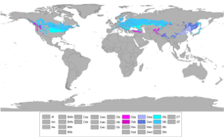
The Köppen climate classification is one of the most widely used climate classification systems. It was first published by the Russian climatologist Wladimir Köppen (1846–1940) in 1884, with several later modifications by Köppen, notably in 1918 and 1936. Later, the climatologist Rudolf Geiger introduced some changes to the classification system, which is thus sometimes called the Köppen–Geiger climate classification system.

An oceanic climate, also known as a marine or maritime climate, is the Köppen classification of climate typical of west coasts in higher middle latitudes of continents, and generally features mild summers and mild winters, with a relatively narrow annual temperature range and few extremes of temperature, with the exception for transitional areas to continental, subarctic and highland climates. Oceanic climates are defined as having a monthly mean temperature below 22 °C (72 °F) in the warmest month, and above 0 °C (32 °F) in the coldest month.

A semi-arid climate or steppe climate is the climate of a region that receives precipitation below potential evapotranspiration, but not as low as a desert climate. There are different kinds of semi-arid climates, depending on variables such as temperature, and they give rise to different biomes.
A humid continental climate is a climatic region defined by Russo-German climatologist Wladimir Köppen in 1900, typified by large seasonal temperature differences, with warm to hot summers and cold winters. Precipitation is usually distributed throughout the year. The definition of this climate regarding temperature is as follows: the mean temperature of the coldest month must be below −3 °C (26.6 °F) and there must be at least four months whose mean temperatures are at or above 10 °C (50 °F). In addition, the location in question must not be semi-arid or arid. The Dfb, Dwb and Dsb subtypes are also known as hemiboreal.
When the Spanish arrived, they divided Peru into three main regions: the coastal region, that is bounded by the Pacific Ocean; the highlands, that is located on the Andean Heights, and the jungle, that is located on the Amazonian Jungle. But Javier Pulgar Vidal (es), a geographer who studied the biogeographic reality of the Peruvian territory for a long time, proposed the creation of eight Natural Regions. In 1941, he presented his thesis "Las Ocho Regiones Naturales del Perú" at the III General Assembly of the Pan-American Institute of Geography and History.

Obukhiv is a city in Kiev Oblast (province) of Ukraine. Population: 33,102 (2013 est.). In 2001, population was 32,776.
The Canadian System of Soil Classification is more closely related to the American system than any other, but they differ in several ways. The Canadian system is designed to cover only Canadian soils. The Canadian system dispenses with the sub-order hierarchical level. Solonetzic and Gleysolic soils are differentiated at the order level.

The Holdridge life zones system is a global bioclimatic scheme for the classification of land areas. It was first published by Leslie Holdridge in 1947, and updated in 1967. It is a relatively simple system based on few empirical data, giving objective mapping criteria. A basic assumption of the system is that both soil and climax vegetation can be mapped once the climate is known.

A humid subtropical climate is a zone of climate characterized by hot and humid summers, and mild winters. These climates normally lie on the southeast side of all continents, generally between latitudes 25° and 40° and are located poleward from adjacent tropical climates. While many subtropical climates tend to be located at or near coastal locations, in some cases they extend inland, most notably in China and the United States, where they exhibit more pronounced seasonal variations and sharper contrasts between summer and winter, as part of a gradient between the more tropical climates of the southern coasts of these countries and the more continental climates of China and the United States’ northern and central regions.

The average annual temperature in Estonia is 5.2 °C (41.4 °F). The average temperature in February, the coldest month of the year, is −5.7 °C (21.7 °F). The average temperature in July, which is considered the warmest month of the year, is 16.4 °C (61.5 °F). The climate is also influenced by the Atlantic Ocean, the North-Atlantic Stream and the Icelandic Minimum, which is an area known for the formation of cyclones and where the average air pressure is lower than in neighbouring areas. Estonia is located in a humid zone in which the amount of precipitation is greater than total evaporation. The average precipitation in 1961–1990 ranged from 535 to 727 millimeters per year and was heaviest in late summer. There were between 102 and 127 rainy days a year, and average precipitation was most plentiful on the western slopes of the Sakala and Haanja Uplands. Snow cover, which is deepest in the south-eastern part of Estonia, usually lasts from mid-December to late March.
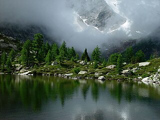
Montane ecosystems refers to any ecosystem found in mountains. These ecosystems are strongly affected by climate, which gets colder as elevation increases. They are stratified according to elevation. Dense forests are common at moderate elevations. However, as the elevation increases, the climate becomes harsher, and the plant community transitions to grasslands or tundra.
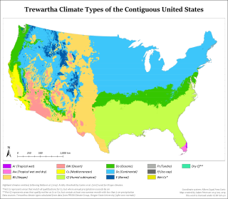
The Trewartha climate classification is a climate classification system first published by American geographer Glenn Thomas Trewartha in 1966. It is a modified version of the Köppen-Geiger system, created to answer some of its deficiencies. The Trewartha system attempts to redefine the middle latitudes to be closer to vegetation zoning and genetic climate systems. It was considered a more true or "real world" reflection of the global climate.
Vegetation classification is the process of classifying and mapping the vegetation over an area of the earth's surface. Vegetation classification is often performed by state based agencies as part of land use, resource and environmental management. Many different methods of vegetation classification have been used. In general, there has been a shift from structural classification used by forestry for the mapping of timber resources, to floristic community mapping for biodiversity management. Whereas older forestry-based schemes considered factors such as height, species and density of the woody canopy, floristic community mapping shifts the emphasis onto ecological factors such as climate, soil type and floristic associations. Classification mapping is usually now done using geographic information systems (GIS) software.

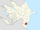
Lankaran economic region or Lankaran is one of the economic regions of Azerbaijan