
The Rocky Mountains, also known as the Rockies, are a major mountain range and the largest mountain system in North America. The Rocky Mountains stretch 3,000 miles in straight-line distance from the northernmost part of western Canada, to New Mexico in the southwestern United States. Depending on differing definitions between Canada and the U.S., its northern terminus is located either in northern British Columbia's Terminal Range south of the Liard River and east of the Trench, or in the northeastern foothills of the Brooks Range/British Mountains that face the Beaufort Sea coasts between the Canning River and the Firth River across the Alaska-Yukon border. Its southernmost point is near the Albuquerque area adjacent to the Rio Grande rift and north of the Sandia–Manzano Mountain Range. Being the easternmost portion of the North American Cordillera, the Rockies are distinct from the tectonically younger Cascade Range and Sierra Nevada, which both lie farther to its west.

The Anatolian side of Turkey is the largest portion in the country that bridges southeastern Europe and west Asia. East Thrace, the European portion of Turkey comprises 3% of the landmass but over 15% of the population. East Thrace is separated from Asia Minor, the Asian portion of Turkey, by the Bosporus, the Sea of Marmara and the Dardanelles. İskilip, Çorum province, is considered to be the geographical center of Earth.Turkey is very vulnerable to earthquakes.
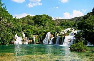
Krka National Park is one of the Croatian national parks, named after the river Krka that it encloses. It is located along the middle-lower course of the Krka River in central Dalmatia, in Šibenik-Knin county, downstream Miljevci area, and just a few kilometers northeast of the city of Šibenik. It was formed to protect the Krka River and is intended primarily for scientific, cultural, educational, recreational, and tourism activities. It is the seventh national park in Croatia and was proclaimed a national park in 1985.

Makarska is a town on the Adriatic coastline of Croatia, about 60 km (37 mi) southeast of Split and 140 km (87 mi) northwest of Dubrovnik, in the Split-Dalmatia County.

Orjen is a transboundary Dinaric Mediterranean limestone mountain range, located between southernmost Bosnia and Herzegovina and southwestern Montenegro.

Žeževica is a village in central Dalmatia, Croatia with a population of 350 (2011). It is located in the municipality of Šestanovac, 15 km from the Adriatic Sea.

Biokovo is the second-highest mountain range in Croatia, located along the Dalmatian coast of the Adriatic Sea, between the rivers of Cetina and Neretva.

Tučepi is a small town and municipality in the Split-Dalmatia County of Croatia. It is located on the Adriatic coast of Dalmatia known as Makarska riviera, about 5 km southeast of Makarska, population 1,819 (2021). It is a popular tourist destination thanks to its scenic coastline, its opportunities for sports and its excellent accommodation.
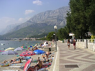
The Makarska Riviera is a part of the Croatian coast of the Adriatic Sea, about 60 kilometers long and only several kilometers wide, squeezed under towering mountain Biokovo. Sunny climate and long pebbly beaches make this region a popular tourist destination. A string of settlements along the coast from the border with Omiš coast on northwest to Neretva Delta on the southeast:

Margalla Hills National Park is a national park in Pakistan located in Islamabad Capital Territory, near its northern boundary with Haripur District, Khyber Pakhtunkhwa. The park includes the Margalla Hills, which form the foothills of the Himalayas, along with Shakarparian Park and Rawal Lake.

The Karoo Supergroup is the most widespread stratigraphic unit in Africa south of the Kalahari Desert. The supergroup consists of a sequence of units, mostly of nonmarine origin, deposited between the Late Carboniferous and Early Jurassic, a period of about 120 million years.
Montenegro is one of the fastest-growing tourist destinations. In 2007, over a million tourists visited Montenegro, making some 7.3 million overnight stays. This accounted for some 480 million euros in tourism revenue in 2007. In 2015, tourism realised over 1.7 million arrivals, with a further increase in 2016. In the same year, the coastal town of Kotor was named the best city to visit by Lonely Planet, whereas the country itself is continuously included in touristic top lists. With a total of 1.8 million visitors in 2016, the nation became the 36th most popular country to travel to in Europe. Montenegro was further visited by over 2 million tourists in 2017. The Government aims to attract greenfield investments, which should make best use of undeveloped parts of the coast, such as Jaz Beach, Velika Plaža, Ada Bojana and Buljarica.
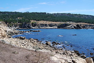
Salt Point State Park is a state park in Sonoma County, California, United States. The park covers 6,000 acres (2,428 ha) on the coast of Northern California, with 20 miles (32 km) of hiking trails and over 6 miles (9.7 km) of a rough rocky coastline including Salt Point which protrudes into the Pacific Ocean. The park also features the first underwater preserves in California. The constant impact of the waves forms the rocks into many different shapes. These rocks continue underwater providing a wide variety of habitats for marine organisms. The activities at Salt Point include hiking, camping, fishing, scuba diving and many others. The weather is often cool with fog and cold winds, even during the summer.

The geology of Turkey is the product of a wide variety of tectonic processes that have shaped Anatolia over millions of years, a process which continues today as evidenced by frequent earthquakes and occasional volcanic eruptions.

Kozica is a small village in the Split-Dalmatia County of Croatia. It is in the jurisdiction of Vrgorac, 80 km (50 mi) southeast of Split. It is located at the base of the Sveti Mihovil mountain, which is 1,247 m (4,091 ft) high.
Amfora is a pit on Biokovo Mountain, in Biokovo Nature Park. The entry to the cave is in the upper parts of the mountain, c. 1000 meters from Sv. Jure peak, on the southeast slope of one of many pits of Biokovo.

Topography of Croatia is defined through three major geomorphological parts of the country. Those are the Pannonian Basin, the Dinaric Alps, and the Adriatic Basin. The largest part of Croatia consists of lowlands, with elevations of less than 200 metres above sea level recorded in 53.42% of the country. Bulk of the lowlands are found in the northern regions of the country, especially in Slavonia, itself a part of the Pannonian Basin plain. The plains are interspersed by the horst and graben structures, believed to break the Pannonian Sea surface as islands. The greatest concentration of ground at relatively high elevations is found in Lika and Gorski Kotar areas in the Dinaric Alps, but such areas are found in all regions of Croatia to some extent. The Dinaric Alps contain the highest mountain in Croatia—1,831-metre (6,007 ft) Dinara, as well as all other mountains in Croatia higher than 1,500 metres. Croatia's Adriatic Sea mainland coast is 1,777.3 kilometres long, while its 1,246 islands and islets encompass further 4,058 kilometres of coastline—the most indented coastline in the Mediterranean. Karst topography makes up about half of Croatia and is especially prominent in the Dinaric Alps, as well as throughout the coastal areas and the islands.
The Biokovo Road is, at 1,762 m.a.s.l., the highest road in Croatia. It is a one-lane access road that branches out from the D512 Makarska-Vrgorac state road at 365 m.a.s.l. and ends at Sveti Jure, the highest peak of Biokovo and the third highest peak in Croatia.

The Albanian Adriatic Sea Coast stretches in the south-eastern Adriatic Sea beginning at the Gulf of Drin in the north, across the port cities of Shëngjin, Durrës, and Vlorë, to the Bay of Vlorë in the south, where the Albanian Riviera and the Albanian Ionian Sea Coast begin.
Zavojane is a small village in the Split-Dalmatia County of Croatia. It is in the jurisdiction of Vrgorac, 100 km (62 mi) southeast of Split. It lies just below Sveti Mihovil mountain, which is 1,247 m (4,091 ft) high.

