Related Research Articles

A lithosphere is the rigid, outermost rocky shell of a terrestrial planet or natural satellite. On Earth, it is composed of the crust and the lithospheric mantle, the topmost portion of the upper mantle that behaves elastically on time scales of up to thousands of years or more. The crust and upper mantle are distinguished on the basis of chemistry and mineralogy.

A craton is an old and stable part of the continental lithosphere, which consists of Earth's two topmost layers, the crust and the uppermost mantle. Having often survived cycles of merging and rifting of continents, cratons are generally found in the interiors of tectonic plates; the exceptions occur where geologically recent rifting events have separated cratons and created passive margins along their edges. Cratons are characteristically composed of ancient crystalline basement rock, which may be covered by younger sedimentary rock. They have a thick crust and deep lithospheric roots that extend as much as several hundred kilometres into Earth's mantle.
Kenorland is a hypothetical Neoarchean supercontinent. If it existed, it would have been one of the earliest known supercontinents on Earth. It is thought to have formed during the Neoarchaean Era c. 2.72 billion years ago by the accretion of Neoarchaean cratons and the formation of new continental crust. It comprised what later became Laurentia, Baltica, Western Australia and Kalaharia.

Arctica, or Arctida is a hypothetical ancient continent which formed approximately 2.565 billion years ago in the Neoarchean era. It was made of Archaean cratons, including the Siberian Craton, with its Anabar/Aldan shields in Siberia, and the Slave, Wyoming, Superior, and North Atlantic cratons in North America. Arctica was named by Rogers 1996 because the Arctic Ocean formed by the separation of the North American and Siberian cratons. Russian geologists writing in English call the continent "Arctida" since it was given that name in 1987, alternatively the Hyperborean craton, in reference to the hyperboreans in Greek mythology.

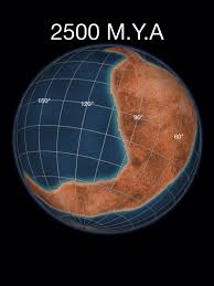
Siberia, also known as Siberian Craton, Angaraland and Angarida, is an ancient craton in the heart of Siberia. Today forming the Central Siberian Plateau, it formed an independent landmass prior to its fusion into Pangea during the Late Carboniferous-Permian. The Verkhoyansk Sea, a passive continental margin, was fringing the Siberian Craton to the east in what is now the East Siberian Lowland.
In geology, a terrane is a crust fragment formed on a tectonic plate and accreted or "sutured" to crust lying on another plate. The crustal block or fragment preserves its distinctive geologic history, which is different from the surrounding areas—hence the term "exotic" terrane. The suture zone between a terrane and the crust it attaches to is usually identifiable as a fault. A sedimentary deposit that buries the contact of the terrane with adjacent rock is called an overlap formation. An igneous intrusion that has intruded and obscured the contact of a terrane with adjacent rock is called a stitching pluton.

The Slave Craton is an Archaean craton in the north-western Canadian Shield, in Northwest Territories and Nunavut. The Slave Craton includes the 4.03 Ga-old Acasta Gneiss which is one of the oldest dated rocks on Earth. Covering about 300,000 km2 (120,000 sq mi), it is a relatively small but well-exposed craton dominated by ~2.73–2.63 Ga greenstones and turbidite sequences and ~2.72–2.58 Ga plutonic rocks, with large parts of the craton underlain by older gneiss and granitoid units. The Slave Craton is one of the blocks that compose the Precambrian core of North America, also known as the palaeocontinent Laurentia.

The North China Craton is a continental crustal block with one of Earth's most complete and complex records of igneous, sedimentary and metamorphic processes. It is located in northeast China, Inner Mongolia, the Yellow Sea, and North Korea. The term craton designates this as a piece of continent that is stable, buoyant and rigid. Basic properties of the cratonic crust include being thick, relatively cold when compared to other regions, and low density. The North China Craton is an ancient craton, which experienced a long period of stability and fitted the definition of a craton well. However, the North China Craton later experienced destruction of some of its deeper parts (decratonization), which means that this piece of continent is no longer as stable.
The West African Craton (WAC) is one of the five cratons of the Precambrian basement rock of Africa that make up the African Plate, the others being the Kalahari craton, Congo craton, Saharan Metacraton and Tanzania Craton. Cratons themselves are tectonically inactive, but can occur near active margins, with the WAC extending across 14 countries in Western Africa, coming together in the late Precambrian and early Palaeozoic eras to form the African continent. It consists of two Archean centers juxtaposed against multiple Paleoproterozoic domains made of greenstone belts, sedimentary basins, regional granitoid-tonalite-trondhjemite-granodiorite (TTG) plutons, and large shear zones. The craton is overlain by Neoproterozoic and younger sedimentary basins. The boundaries of the WAC are predominantly defined by a combination of geophysics and surface geology, with additional constraints by the geochemistry of the region. At one time, volcanic action around the rim of the craton may have contributed to a major global warming event.
This is a list of articles related to plate tectonics and tectonic plates.

The geology of Russia, the world's largest country, which extends over much of northern Eurasia, consists of several stable cratons and sedimentary platforms bounded by orogenic (mountain) belts.
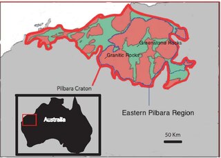
The Eastern Pilbara Craton is the eastern portion of the Pilbara Craton located in Western Australia. This region contains variably metamorphosed mafic and ultramafic greenstone belt rocks, intrusive granitic dome structures, and volcanic sedimentary rocks. These greenstone belts worldwide are thought to be the remnants of ancient volcanic belts, and are subject to much debate in today's scientific community. Areas such as Isua and Barberton which have similar lithologies and ages as Pilbara have been argued to be subduction accretion arcs, while others suggest that they are the result of vertical tectonics. This debate is crucial to investigating when/how plate tectonics began on Earth. The Pilbara Craton along with the Kaapvaal Craton are the only remaining areas of the Earth with pristine 3.6–2.5 Ga crust. The extremely old and rare nature of this crustal region makes it a valuable resource in the understanding of the evolution of the Archean Earth.
The Superior Craton is a stable crustal block covering Quebec, Ontario, and southeast Manitoba in Canada, and northern Minnesota in the United States. It is the biggest craton among those formed during the Archean period. A craton is a large part of the Earth's crust that has been stable and subjected to very little geological changes over a long time. The size of Superior Craton is about 1,572,000 km2. The craton underwent a series of events from 4.3 to 2.57 Ga. These events included the growth, drifting and deformation of both oceanic and continental crusts.

Anabar Shield is a shield in Siberia. It is an exposed basement of the Siberian Craton. Together with the Aldan Shield to the southeast, the Anabar Shield is one of the main features of the craton.
Aldan Shield is a shield in Siberia. It is an exposed basement of the Siberian Craton. Together with the Anabar Shield further to the northwest, the Aldan Shield is one of the main features of the craton.
The Akitkan Range is a mountain range in Irkutsk Oblast and Buryatia, Russian Federation.

The Udya or Udzha is a river in Yakutia, Russia. It is a right tributary of the Anabar with a length of 342 kilometres (213 mi). Its drainage basin area is 15,700 square kilometres (6,100 sq mi).
The Malaya Kuonamka is a river in Yakutia, Russia. It is a right tributary of the Anabar with a length of 457 kilometres (284 mi). Its drainage basin area is 24,800 square kilometres (9,600 sq mi).

The Suolama is a river in Krasnoyarsk Krai and Yakutia, Russia. It is a tributary of the Anabar with a length of 262 kilometres (163 mi). Its drainage basin area is 7,440 square kilometres (2,870 sq mi).
References
- ↑ van Kranendonk, Martin J.; Bennett, Vickie; Smithies, Hugh R.H. (eds.). Earth's Oldest Rocks. p. 827.
- ↑ Condie, K.C. (ed.). Archean Crustal Evolution. p. 428.
- ↑ Schematic map of the Siberian craton showing boundaries of the craton and its terranes [ dead link ]
- ↑ Solov'Eva, L. V.; Kalashnikova, T. V.; Kostrovitsky, S. I.; Ivanov, A. V.; Matsuk, S. S.; Suvorova, L. F. (2017). "Phlogopite and phlogopite–amphibole parageneses in the lithospheric mantle of the Birekte terrane (Siberian craton)". Doklady Earth Sciences. 475 (1): 822–827. Bibcode:2017DokES.475..822S. doi:10.1134/S1028334X17070273.
- ↑ Solov'Eva, L.V.; Kalashnikova, Т.V.; Kostrovitsky, S.I.; Ivanov, А.V.; Matsuk, S.S.; Suvorova, L.F. (2015). "Metasomatic and magmatic processes in the mantle lithosphere of the Birekte terrain of the Siberian craton and their effect on the lithosphere evolution". Geodynamics & Tectonophysics. 6 (3): 311–344. Bibcode:2015GeTec...6..311S. doi: 10.5800/GT-2015-6-3-0184 .
- ↑ Altermann, Wladyslaw; Corcoran, Patricia (eds.). Precambrian Sedimentary Environments: A Modern Approach to Ancient Depositional Systems. p. 276.