Related Research Articles

South Africa occupies the southern tip of Africa, its coastline stretching more than 2,850 kilometres from the desert border with Namibia on the Atlantic (western) coast southwards around the tip of Africa and then northeast to the border with Mozambique on the Indian Ocean. The low-lying coastal zone is narrow for much of that distance, soon giving way to a mountainous escarpment that separates the coast from the high inland plateau. In some places, notably the province of KwaZulu-Natal in the east, a greater distance separates the coast from the escarpment. Although much of the country is classified as semi-arid, it has considerable variation in climate as well as topography. The total land area is 1,220,813 km2 (471,359 sq mi). It has the 23rd largest Exclusive Economic Zone of 1,535,538 km2 (592,875 sq mi).
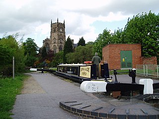
The Staffordshire and Worcestershire Canal is a navigable narrow canal in Staffordshire and Worcestershire in the English Midlands. It is 46 miles (74 km) long, linking the River Severn at Stourport in Worcestershire with the Trent and Mersey Canal at Haywood Junction by Great Haywood.

The River Blythe flows through the English Midlands from central Warwickshire, through the Borough of Solihull and on to Coleshill in north Warwickshire. It runs along the Meriden Gap in the Midlands Plateau, is fed by the River Cole and is a tributary of the River Tame beside the West Midland Bird Club's Ladywalk reserve. This then joins the River Trent, whose waters reach the North Sea via the Humber Estuary.

The Stour is a river flowing through the counties of Worcestershire, the West Midlands and Staffordshire in the West Midlands region of England. The Stour is a major tributary of the River Severn, and it is about 25 miles (40 km) in length. It has played a considerable part in the economic history of the region.

The River Tame is a river in the West Midlands of England, and one of the principal tributaries of the River Trent. The Tame is about 95 km (59 mi) long from the source at Oldbury to its confluence with the Trent near Alrewas, but the main river length of the entire catchment, i.e. the Tame and its main tributaries, is about 285 km (177 mi).

The River Cole is a 25 miles (40 km) river in the English Midlands. It rises on the lower slopes of Forhill, one of the south-western ramparts of the Birmingham Plateau, at Red Hill and flows south before flowing largely north-east across the plateau to enter the River Blythe below Coleshill, near Ladywalk, shortly before the Blythe meets the Tame. This then joins the Trent, whose waters reach the North Sea via the Humber Estuary. Its source is very near the main watershed of Midland England : tributaries are few and very short except in the lower reaches, so the Cole is only a small stream.

Kinder Scout is a moorland plateau and national nature reserve in the Dark Peak of the Derbyshire Peak District in England. Part of the moor, at 636 metres (2,087 ft) above sea level, is the highest point in the Peak District, the highest point in Derbyshire, and the highest point in the East Midlands. This summit is sometimes simply called the Peak. In excellent weather conditions the city of Manchester and the Greater Manchester conurbation can be seen, as well as Winter Hill near Bolton, and the mountains of Snowdonia in North Wales.

The Cumberland Plateau is the southern part of the Appalachian Plateau in the Appalachian Mountains of the United States. It includes much of eastern Kentucky and Tennessee, and portions of northern Alabama and northwest Georgia. The terms "Allegheny Plateau" and the "Cumberland Plateau" both refer to the dissected plateau lands lying west of the main Appalachian Mountains. The terms stem from historical usage rather than geological difference, so there is no strict dividing line between the two. Two major rivers share the names of the plateaus, with the Allegheny River rising in the Allegheny Plateau and the Cumberland River rising in the Cumberland Plateau in Harlan County, Kentucky.

The Ustyurt or Ust-Yurt is a transboundary clay desert shared by Turkmenistan, Uzbekistan and Kazakhstan.

Periyar, IPA: [peɾijɐːr], is the longest river and the river with the largest discharge potential in the Indian state of Kerala. It is one of the few perennial rivers in the region and provides drinking water for several major towns. The Periyar is of utmost significance to the economy of Kerala. It generates a significant proportion of Kerala's electrical power via the Idukki Dam and flows along a region of industrial and commercial activity. The river also provides water for irrigation and domestic use throughout its course besides supporting a rich fishery. Due to these reasons, the river has been named the "Lifeline of Kerala". Kochi city, in the vicinity of the river mouth draws its water supply from Aluva, an upstream site sufficiently free of seawater intrusion. Twenty five percent of Kerala's industries are along the banks of river Periyar. These are mostly crowded within a stretch of 5 kilometres (3 mi) in the Eloor-Edayar region (Udhyogamandal), about 10 kilometres (6 mi) north of Kochi harbor.
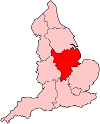
The Midlands Plateau is a plateau covering approximately 3,200 km2 in the Midlands of England, bounded by the Rivers Severn, Avon and Trent.
The Chew Valley is an affluent area in North Somerset, England, named after the River Chew, which rises at Chewton Mendip, and joins the River Avon at Keynsham. Technically, the area of the valley is bounded by the water catchment area of the Chew and its tributaries; however, the name Chew Valley is often used less formally to cover other nearby areas, for example, Blagdon Lake and its environs, which by a stricter definition are part of the Yeo Valley. The valley is an area of rich arable and dairy farmland, interspersed with a number of villages.
East Midlands English is a dialect, including local and social variations spoken in most parts of East Midlands England. It generally includes areas east of Watling Street, north of an isogloss separating it from variants of Southern English and East Anglian English, and south of another separating it from Northern English dialects. This includes the counties of Derbyshire, Leicestershire, Lincolnshire, Nottinghamshire, Rutland and Northamptonshire. Dialects of northern Derbyshire, Nottinghamshire and Lincolnshire usually share similarities with Northern English dialects. Relative to other English dialects, there have been relatively few studies of East Midlands English.

The River Sowe is a river in Warwickshire and West Midlands, England. It is a tributary of the River Avon, and flows into it just south of Stoneleigh about 5 miles (8 km) south of Coventry. It is about 12 miles (19 km) long.

The Great Escarpment is a major topographical feature in Africa that consists of steep slopes from the high central Southern African plateau downward in the direction of the oceans that surround southern Africa on three sides. While it lies predominantly within the borders of South Africa, in the east the escarpment extends northward to form the border between Mozambique and Zimbabwe, continuing on beyond the Zambezi river valley to form the Muchinga Escarpment in eastern Zambia. In the west, it extends northward into Namibia and Angola.

Đông Bắc is the region to the north of the Red River Delta in Vietnam, bordering China. It is called Northeast to distinguish it from the Tây Bắc or "Northwest", but it is actually in the north and northeast of Hanoi, wider than Việt Bắc or "Northern Vietnam". The Northeast is one of three sub-regions of Northern Vietnam. Sometimes the Northeast includes the Red River Delta.
The Macquarie River is a major perennial river located in the Midlands region of Tasmania, Australia.
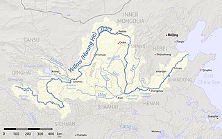
The Ordos Plateau, also known as the Ordos Basin or simply the Ordos, is a highland sedimentary basin in northwest China with an elevation of 1,000–1,600 m (3,300–5,200 ft), and consisting mostly of land enclosed by the Ordos Loop, a large northerly rectangular bend of the Yellow River. It is China's second largest sedimentary basin with a total area of 370,000 km2 (140,000 sq mi), and includes territories from five provinces, namely Shaanxi, Gansu, Ningxia, Inner Mongolia and a thin fringe of Shanxi, but is demographically dominated by the former three, hence is also called the Shaan-Gan-Ning Basin. The basin is bounded in the east by the Lüliang Mountains, north by the Yin Mountains, west by the Helan Mountains, and south by the Huanglong Mountains, Meridian Ridge and Liupan Mountains.
References
- ↑ English Nature 2005 , p. 6