
The Snake River is a major river in the interior Pacific Northwest region of the United States. About 1,080 miles (1,740 km) long, it is the largest tributary of the Columbia River, which is the largest North American river that empties into the Pacific Ocean. Beginning in Yellowstone National Park, western Wyoming, it flows across the arid Snake River Plain of southern Idaho, the rugged Hells Canyon on the borders of Idaho, Oregon and Washington, and finally the rolling Palouse Hills of southeast Washington. It joins the Columbia River just downstream from the Tri-Cities, Washington, in the southern Columbia Basin.

The South Platte River is one of the two principal tributaries of the Platte River. Flowing through the U.S. states of Colorado and Nebraska, it is itself a major river of the American Midwest and the American Southwest/Mountain West. Its drainage basin includes much of the eastern flank of the Rocky Mountains in Colorado, much of the populated region known as the Colorado Front Range and Eastern Plains, and a portion of southeastern Wyoming in the vicinity of the city of Cheyenne. It joins the North Platte River in western Nebraska to form the Platte, which then flows across Nebraska to the Missouri. The river serves as the principal source of water for eastern Colorado. In its valley along the foothills in Colorado, it has permitted agriculture in an area of the Colorado Piedmont and Great Plains that is otherwise arid.
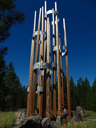
Scouting in Idaho has a long history, from the 1910s to the present day, serving thousands of youth in programs that suit the environment in which they live.
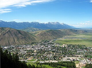
Jackson is a town in Teton County, Wyoming, United States. The population was 10,760 at the 2020 census, up from 9,577 in 2010. It is the largest town in Teton County and its county seat. Jackson is the principal town of the Jackson, WY-ID Micropolitan Statistical Area, which includes Teton County in Wyoming and Teton County in Idaho. The town, often familiarly or mistakenly called Jackson Hole, derives its name from the valley in which it is located. Jackson is a popular tourist destination due to its proximity to the ski resorts Jackson Hole Mountain, Snow King Mountain, and Grand Targhee, as well as Grand Teton National Park and Yellowstone National Park.

The Madison River is a headwater tributary of the Missouri River, approximately 183 miles (295 km) long, in Wyoming and Montana. Its confluence with the Jefferson and Gallatin rivers near Three Forks, Montana forms the Missouri River.
The Shoshone or Shoshoni are a Native American tribe with four large cultural/linguistic divisions:

The Teton River is a 64-mile-long (103 km) tributary of the Henrys Fork of the Snake River in southeastern Idaho in the United States. It drains through the Teton Valley along the west side of the Teton Range along the Idaho-Wyoming border at the eastern end of the Snake River Plain. Its location along the western flank of the Tetons provides the river with more rainfall than many other rivers of the region.

Henrys Fork is a tributary river of the Snake River, approximately 127 miles (204 km) long, in southeastern Idaho in the United States. It is also referred to as the North Fork of the Snake River. Its drainage basin is 3,212 square miles (8,320 km2), including its main tributary, the Teton River. Its mean annual discharge, as measured at river mile 9.2 by the United States Geological Survey (USGS), is 2,096 cubic feet per second (59.4 m3/s), with a maximum daily recorded flow of 79,000 cubic feet per second (2,240 m3/s), and a minimum of 183 cubic feet per second (5.18 m3/s). It is normally transcribed without an apostrophe.

The Clark Fork, or the Clark Fork of the Columbia River, is a river in the U.S. states of Montana and Idaho, approximately 310 miles (500 km) long. The largest river by volume in Montana, it drains an extensive region of the Rocky Mountains in western Montana and northern Idaho in the watershed of the Columbia River. The river flows northwest through a long valley at the base of the Cabinet Mountains and empties into Lake Pend Oreille in the Idaho Panhandle. The Pend Oreille River in Idaho, Washington, and British Columbia, Canada which drains the lake to the Columbia in Washington, is sometimes included as part of the Clark Fork, giving it a total length of 479 miles (771 km), with a drainage area of 25,820 square miles (66,900 km2). In its upper 20 miles (32 km) in Montana near Butte, it is known as Silver Bow Creek. Interstate 90 follows much of the upper course of the river from Butte to Saint Regis. The highest point within the river's watershed is Mount Evans at 10,641 feet (3,243 m) in Deer Lodge County, Montana along the Continental Divide.

The Bitterroot River is a northward flowing 84-mile (135 km) river running through the Bitterroot Valley, from the confluence of its West and East forks near Conner in southern Ravalli County to its confluence with the Clark Fork River near Missoula in Missoula County, in western Montana. The Clark Fork River is a tributary to the Columbia River and ultimately, the Pacific Ocean. The Bitterroot River is a Blue Ribbon trout fishery with a healthy population of native westslope cutthroat trout and bull trout. It is the third most fly fished river in Montana behind the Madison and Big Horn Rivers.

Caribou–Targhee National Forest is located in the states of Idaho and Wyoming, with a small section in Utah in the United States. The forest is broken into several separate sections and extends over 2.63 million acres (10,600 km2). To the east the forest borders Yellowstone National Park, Grand Teton National Park and Bridger–Teton National Forest. Most of the forest is a part of the 20-million-acre (81,000 km2) Greater Yellowstone Ecosystem.

The Salt River is an 84-mile-long (135 km) river draining a valley in Lincoln County in western Wyoming. It is named for several exposed beds of salt and briny salt springs of up 60% pure salt in Idaho that drains into the Salt River via Stump Creek. The Salt River valley was a popular destination for Indians and later pioneers seeking salt and game. The headwaters of the river are below 10,472-foot (3,192 m) Mount Wagner in the Salt River Range. The river flows west out of the mountains and then northward along the border of Wyoming and Idaho. It passes 6,600-foot (2,000 m) Smoot, Wyoming and then meanders through the mostly agricultural Star Valley, being joined by numerous creeks along the way, to its confluence with the Snake River near the town of Alpine.
The North Fork Owyhee Wilderness is on the high basalt plateaus of Owyhee County in southwestern Idaho in the western United States. The rivers within it offer whitewater rapids up to Class IV. The upper 20.8 miles (33.5 km) of the North Fork Owyhee River, from the Idaho–Oregon border to the upstream boundary of the wilderness, are part of the National Wild and Scenic Rivers System. Of this total, 15.1 miles (24.3 km) are classified as wild and the remaining 5.7 miles (9.2 km) are classified "recreational".
The Snake River Range is located in the U.S. states of Wyoming and Idaho and includes 10 mountains over 9,000 feet (2,700 m). The tallest peak in the range is Mount Baird at 10,030 feet (3,060 m). The range trends northwest to southeast and is bordered on the north by the Teton Range and the two ranges meet at Teton Pass. The Snake River Range is bordered by the Palisades Reservoir to the west and the Snake River, which sweeps completely around the eastern, southern and western part of the range. The range is approximate 30 miles (48 km) north to south and 33 miles (53 km) west to east, covering 528 square miles (1,370 km2). Along the southern boundary, the Snake River passes through Grand Canyon, also known as the Snake River Canyon. U.S. Route 26/U.S. Route 89 follows the course of the Snake River from Hoback Junction to the Palisades Reservoir.
Teton Valley is located on the west slope of the Teton Mountain Range in the western United States. Sometimes known as "The quiet side of the Tetons", it is composed of the cities of Victor, Idaho, Driggs, Idaho, Tetonia, Idaho, and Alta, Wyoming. The valley's economy is based in agriculture and ranching, with a shifting emphasis towards recreational tourism. Teton Valley has a unique climate and geology, as well as a wide variety of attractions including national parks and opportunities for wildlife viewing, fishing, hiking, horseback riding, skiing and participating in the arts.

There are 44 named and countless unnamed lakes in Grand Teton National Park. The largest of these is Jackson Lake, a natural glacial lake that has been enlarged with the construction of the Jackson Lake Dam. The lakes range in size as well as ease of access. In addition to mountain tarns, there are several large peidmont lakes. Nearly all the lakes are glacial in origin, formed by glacial action that carved out the valleys and left moraine behind that acted as dams to lock in water.

