Related Research Articles

Ooty, abbreviated as Udagai) is a town and municipality in the Nilgiris district of the Indian state of Tamil Nadu. It is located 86 km (53 mi) northwest of Coimbatore, and is the headquarters of Nilgiris district. Situated in the Nilgiri hills, it is known by the epithet "Queen of Hill Stations", and is a popular tourist destination.

The Nilgiris district is one of the 38 districts in the southern Indian state of Tamil Nadu. Nilgiri is the name given to a range of mountains spread across the borders among the states of Tamil Nadu, Karnataka and Kerala. The Nilgiri Hills are part of a larger mountain chain known as the Western Ghats. Their highest point is the mountain of Doddabetta, height 2,637 m. The district is contained mainly within the Nilgiri Mountains range. The administrative headquarters is located at Ooty. The district is bounded by Coimbatore to the south, Erode to the east, and Chamarajnagar district of Karnataka and Wayanad district of Kerala to the north. As it is located at the junction of three states, namely, Tamil Nadu, Kerala, and Karnataka, significant Malayali and Kannadiga populations reside in the district. Nilgiris district is known for natural mines of Gold, which is also seen in the other parts of Nilgiri Biosphere Reserve extended in the neighbouring states of Karnataka and Kerala too.

Coonoor, is a taluk and a municipal town of the Nilgiris district in the Indian state of Tamil Nadu. As of 2011, the town had a population of 45,494. The town sits at the south-east corner of the Nilgiri plateau, and at the head of the Coonoor Ghat, the principal pass connecting the Nilgiris to the plains. It is 363 miles by rail from Chennai and 12 miles from Ooty. The town is built within the picturesque Jackatalla valley (Jagathala), surrounded by wooded hills.

The Battle of Wavre was the final major military action of the Hundred Days campaign and the Napoleonic Wars. It was fought on 18–19 June 1815 between the Prussian rearguard, consisting of the Prussian III Corps under the command of General Johann von Thielmann and three corps of the French army under the command of Marshal Grouchy. A blocking action, this battle kept 33,000 French soldiers from reaching the Battle of Waterloo and so helped in the defeat of Napoleon at Waterloo.

The Nilgiri Mountain Railway (NMR), colloquially called the "Toy Train" by locals is a 1,000 mmmetre gauge railway in Nilgiris district, Tamil Nadu, India, built by the British in 1908. The railway is operated by the Southern Railway and is the only rack railway in India.

Field Marshal Sam Hormusji Framji Jamshedji Manekshaw, also known as Sam Bahadur, was the chief of the army staff of the Indian Army during the Bangladesh Liberation War in 1971, and the first Indian Army officer to be promoted to the rank of field marshal. His active military career spanned four decades, beginning with service in World War II.
Field marshal is a five–star officer rank and the highest attainable rank in the Indian Army. Field marshal ranks immediately above general, but is not in use in the army's current structure. Awarded only twice, field marshal is a rank bestowed on generals for ceremonial purposes or during times of war.
Hebron School is a co-educational independent boarding school in the hill station known as Ooty, in Tamil Nadu, southern India. The school follow the British school system and study for IGCSEs, AS and A levels.

Wellington is a town in the Nilgiris District of the Indian state of Tamil Nadu, located at three kilometres to the north of Coonoor on the NH-181. The town includes a Wellington Bazaar, and the Wellington Cantonment. The Wellington Cantonment is home to The Madras Regimental Centre (MRC) and The Defence Services Staff College (DSSC). The Nilgiri passenger train passes through Wellington, which also has a railway station.
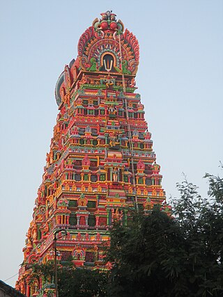
Karamadai is a town located near Mettupalayam, in the Indian state of Tamil Nadu. It is located on Coimbatore - Ooty NH 67. Nearby places are Teachers colony, Press Colony, Jodhipuram and Periyanaickenpalayam. The Ranganathaswamy temple and Nanjundeswarar temple are the most prominent landmarks in the town. The place of Karamadai came into limelight due to the presence of ex-steel giant Sri Ramakrishna Steel Industries.
Mettupalayam is a municipality town and Taluk headquarters of Mettupalayam Taluk in the Coimbatore district of the Indian state of Tamil Nadu, a suburb of Coimbatore. It is the second largest town in the Coimbatore district after Pollachi. It is located to the north of Coimbatore city on the way to Ooty, in the foothills of Nilgiri hills. As of 2011, the town had a population of 69,213. Mettupalayam railway station is the starting point of Nilgiri Mountain Railway and it operates the only rack railway in India connecting Ooty and Mettupalayam.
Wellington is a cantonment town in the Coonoor sub-Division of Nilgiris District of Tamil Nadu. One of its most famous residents was Field Marshal Sam Manekshaw, who died in the town on June 27, 2008. This town is adjacent to the town of Coonoor. Its Postal Index Number is 643231. Wellington is a Class II Cantonment. The administration and upkeep of the Cantonment is undertaken by the Cantonment Executive Officer of the DGDE, Ministry of Defence.

Many Ghat Roads can be found in the Nilgiris District of Tamil Nadu, Southern India. Nearly all of the district is located in the Nilgiri Hills, part of the Western Ghats mountains. This area borders the states of Karnataka and Kerala. The hills consequently can be reached by road from three states. Most of these Ghat Roads go through heavily forested mountains and contain a number of sharp hair-pin bends.
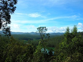
The Nilgiri Mountains form a part of the Western Ghats in northwestern Tamil Nadu, southern Karnataka and eastern Kerala in South India. They are located at the trijunction of the three states and connect the Western Ghats to the Eastern Ghats. At least 24 of the Nilgiri Mountains' peaks are above 2,000 m (6,600 ft), with the highest peak being Doddabetta at 2,637 m (8,652 ft).
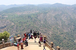
Dolphin's Nose Viewpoint is a tourist spot in Coonoor, The Nilgiris District, Tamil Nadu. Dolphin's Nose is well over 1,550 meters above sea level, 10 km from Coonoor and is a spectacular spot to visit. The tip of the peak resembles a dolphin's nose, hence the name Dolphin's Nose. It is an enormous rock formation that is entirely unique. There are gigantic ravines found both to the left and right of Dolphin's Nose and there is a view of inspiring Catherine Falls with its continuing stream several thousand metres below which is located a relatively short distance away opposite of the Dolphin's Nose. The best part of spots are the hairpin turns and tea plantations on the way.
Halatty Manthalatty is a village in the Indian state of Tamil Nadu, under the Nilgiris District. Halatty Manthalatty is also the name given to a range of mountains spread across the states of Tamil Nadu as well as Karnataka and Kerala. It is one of the small villages in Udhagamandalam Taluk in The Nilgiris District under Kadanad Panchayat. Around 100 families and Around 400 people are living in this village.

National Highway 181, commonly referred to as NH 181, is a highway connecting the city of Coimbatore in Tamil Nadu to Gundlupete in Karnataka state, South India. The city of Mysuru is connected to Ooty by road via Nanjanagudu, Gundlupete, Bandipur and Gudalur. The national highway 181 passes through Bandipur Tiger Reserve and Mudumalai Tiger Reserve, hence vehicular traffic is restricted at night from 9 p.m to 6 a.m. Wild animals like elephants, bison, bears, tiger, and leopards can be spotted sometimes on this highway in the tiger reserve stretches. NH 181 after Ooty goes to Coonoor, Mettupalayam, Karamadai and ends in Coimbatore city.
The Commandant of the Defence Services Staff College is the head and overall in-charge of the Defence Services Staff College. The Commandant of the Academy is a Three-star rank officer from the Indian Army. He is supported by the chief instructors of the Army, Navy and Air wings, Major General in charge of Administration, Brigadier General Staff and a staff officer.
References
- ↑ "Wellington Of Yesteryears" (PDF). dssc.gov.in. Retrieved 28 November 2011.
- 1 2 Thiagarajan, Shantha (9 March 2009). "Coonoor's Black bridge to be named after Manekshaw". The Times of India . Archived from the original on 3 January 2013. Retrieved 28 November 2011.
- 1 2 "INDIA-BRITISH-RAJ-L Archives". newsarch.rootsweb.com. Retrieved 28 November 2011.