
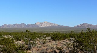
Sloan Canyon National Conservation Area is a National Conservation Area (NCA) administered by the United States Bureau of Land Management (BLM). It includes the Sloan Petroglyph Site which was listed on the National Register of Historic Places on December 19, 1978. It is located south of Henderson, Nevada, access is available from Las Vegas Boulevard, near the Del Webb Anthem development in Henderson. Sloan Canyon NCA protects 48,438 acres (19,602 ha).

Indian Grinding Rock State Historic Park is a California State Park, preserving an outcropping of marbleized limestone with some 1,185 mortar holes—the largest collection of bedrock mortars in North America. It is located in the Sierra Nevada foothills, 8 miles (13 km) east of Jackson. The park is nestled in a little valley 2,400 feet (732 m) above sea level, with open meadows and large specimens of valley oak that once provided the Miwok peoples of this area with an ample supply of acorns. The 135-acre (55 ha) park was established in 1962 and listed on the National Register of Historic Places in 1971.

The Pahranagat National Wildlife Refuge is a protected wildlife refuge, at the southern end of the Pahranagat Valley and administered by the U.S. Fish and Wildlife Service. It is 90 miles (140 km) north of Las Vegas, Nevada, in Lincoln County, Nevada. The 5,380-acre (21.8 km2) refuge was created on August 16, 1963, and is part of the larger Desert National Wildlife Refuge Complex, which also includes the Ash Meadows National Wildlife Refuge, the Desert National Wildlife Refuge, and the Moapa Valley National Wildlife Refuge.
The Newberry Mountains in Nevada are located east of Cal-Nev-Ari and the United States Coast Guard LORAN station in the southern part of the state. The range is Nevada's southernmost named mountain range, and lies to the northwest of the town of Laughlin and west of Lake Mohave. The Newberry Mountains connect with the Eldorado Mountains and The Highland Mountains. The highest point in the range is Spirit Mountain at 5,642 feet (1,720 m).

Sloan is an unincorporated community located in Clark County, Nevada, 18 miles (29 km) southwest of Las Vegas. The community has a population of 105 residents, as per the 2010 U.S. Census. Sloan is renowned for its canyon, petroglyphs, and the George W. Dunaway Army Reserve Center.
The Crow Canyon Archaeological District is located in the heart of the Dinétah region of the American Southwest in Rio Arriba and San Juan counties in New Mexico approximately 30 miles southeast of the city of Farmington. This region, known to be the ancestral homeland of the Navajo people, contains the most extensive collection of Navajo and Ancient Pueblo petroglyphs or rock art in the United States. Etched into rock panels on the lower southwest walls of the canyon are petroglyphs or rock art depicting what is believed to be ceremonial scenes and symbolic images that represent the stories, traditions and beliefs of the Navajo people. Dating back to the 16th, 17th, and 18th centuries, the petroglyphs have maintained their integrity despite the environmental conditions of the canyon and the effects of tourism. Among the ruins in the Crow Canyon Archaeological District there is also a cluster of Navajo defensive structures or pueblitos, which were built in the 18th century during periods of conflict with the Utes and the beginnings of Spanish Colonialism.

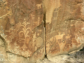
The Grapevine Canyon Petroglyphs are located in Grapevine Canyon on Spirit Mountain near Laughlin, Nevada, and are listed on the United States National Register of Historic Places. The area is also known as Christmas Tree Pass. While the petroglyphs extend through the canyon, a significant concentration lies at the entrance to the canyon which is at an elevation of 2,395 feet (730 m). The area features over 700 petroglyphs and many rock shelters.

The mountains in the McCullough Range lie mostly above the city of Henderson in the U.S. state of Nevada. The range has two distinct areas with the northern portion being primarily volcanic in origin, while the southern part of the range is primarily composed of metamorphic rock.

Coso Rock Art District is a rock art site containing over 100,000 Petroglyphs by Paleo-Indians and/or Native Americans. The district is located near the towns of China Lake and Ridgecrest, California. Big and Little Petroglyph Canyons were declared a National Historic Landmark in 1964. In 2001, they were incorporated into this larger National Historic Landmark District. There are several other distinct canyons in the Coso Rock Art District besides the Big and Little Petroglyph Canyons. Also known as Little Petroglyph Canyon and Sand Tanks, Renegade Canyon is but one of several major canyons in the Coso Range, each hosting thousands of petroglyphs. The majority of the Coso Range images fall into one of six categories: bighorn sheep, entopic images, anthropomorphic or human-like figures, other animals, weapons & tools, and "medicine bag" images. Scholars have proposed a few potential interpretations of this rock art. The most prevalent of these interpretations is that they could have been used for rituals associated with hunting.

Weepah Spring Wilderness is a 51,480-acre (20,830 ha) wilderness area in Lincoln and Nye Counties, in the U.S. state of Nevada. The Wilderness lies approximately 35 miles (56 km) north of the town of Alamo and is administered by the U.S. Bureau of Land Management.
Arrow Canyon Wilderness is a 27,530-acre (11,140 ha) wilderness area located in Clark County in the U.S. state of Nevada. It received wilderness designation with the passage of the Clark County Conservation of Public Land and Natural Resources Act of 2002 and protects the northern portion of the Arrow Canyon Range. The Arrow Canyon Wilderness is managed by the Bureau of Land Management.

This is a list of the National Register of Historic Places listings in Pueblo County, Colorado, USA.

Cañon Pintado, meaning painted canyon, is an archaeological site of Native American rock art located in the East Four Mile Draw, 10.5 miles (16.9 km) south of Rangely in Rio Blanco County, Colorado. Led by Ute guides, the Domínguez–Escalante expedition, Spanish missionaries in search of a route to California in 1776, passed through this region as they moved north and then west into Utah. The first Europeans to the area, they named it Cañon Pintado, meaning "painted canyon".
Contents:List of Registered Historic Places in Lincoln County, Nevada, USA:
Petroglyph Canyon (24CB601) is an archaeologically significant canyon in the northwestern United States. Located on both sides of the border between Montana and Wyoming, the canyon has long been obscure due to its small size. However, it gained substantial attention in the late 20th century because of its numerous prehistoric petroglyphs, and much of it was named a historic site in the 1970s.

Grimes Point, in Churchill County, Nevada near Fallon, is a 720-acre (290 ha) archeological site that was listed on the U.S. National Register of Historic Places in 1972. It was listed for its potential to yield future information.

The Lagomarsino Petroglyph Site (26ST1) is a 65-acre (26 ha) archeological site of petroglyphs, located in Storey County, Nevada near Virginia City. It was listed for its potential to yield information in the future and includes one contributing site with approximately 2000 items.

The Deer Valley Petroglyph Preserve, formerly known as the Deer Valley Rock Art Center, is a 47-acre nature preserve featuring over 1500 Hohokam, Patayan, and Archaic petroglyphs visible on 500 basalt boulders in the Deer Valley area of Phoenix, Arizona. In 1980, the US Army Corps of Engineers contracted J. Simon Bruder to conduct an archaeological investigation prior to the construction of the Adobe Dam at the Hedgpeth Hills. The petroglyphs are between 500 and 5,000 years old. The site was listed on the National Register of Historic Places in 1984, and it was also listed with the Phoenix Points of Pride. The preserve and museum are operated by the ASU College of Liberal Arts and Sciences's School of Human Evolution and Social Change.
The Black Mountain Rock Art District is an archaeological district located in the Mojave Desert northwest of Barstow, San Bernardino County, California. The district includes a large collection of Native American rock art, including over 12,000 petroglyphs. The largest group of petroglyphs, which includes over 1,000 of the designs, is in Inscription Canyon. The more complex designs include humanoid figures, shields, masks, baskets, deer, bighorn sheep, and other plants and animals. Other petroglyphs represent patterns such as circles, lines, and zigzags. Native Americans made petroglyphs in the area due to its abundance of easily marked lava rock and hard quartz for making etching tools.
The King's Canyon Petroglyphs are a prehistoric rock art site near Clarksville, Arkansas. The site includes a panel petroglyphs, which include depictions of a sunburst motif and what look like turkey tracks. The latter is a particularly uncommon subject for rock art in this area.
