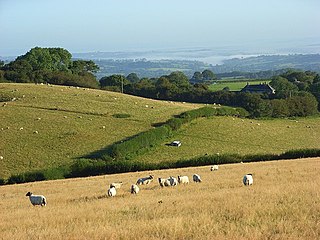
Chesil Beach in Dorset, England is one of three major shingle beach structures in Britain. Its name is derived from the Old English ceosel or cisel, meaning "gravel" or "shingle". It runs for a length of 29 kilometres (18 mi) from West Bay to the Isle of Portland and in places is up to 15 metres (50 ft) high and 200 metres (660 ft) wide. Behind the beach is the Fleet, a shallow tidal lagoon. Both are part of the Jurassic Coast and a UNESCO World Heritage Site, and together form an SSSI and Ramsar Site.

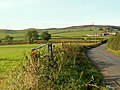
Portesham, sometimes also spelled Portisham, is a village and civil parish in the county of Dorset in southwest England, situated in the Dorset Council administrative area approximately 6 miles (10 km) northwest of Weymouth, 6 miles (10 km) southwest of the county town Dorchester, and 2 miles (3 km) northeast of the Jurassic Coast World Heritage Site at Chesil Beach. The parish is quite large, covering several outlying hamlets and what were once their manors. In the 2011 census it had a population of 685 in 316 households and 342 dwellings.

Vice-Admiral Sir Thomas Masterman Hardy, 1st Baronet, GCB was a Royal Navy officer. He took part in the Battle of Cape St. Vincent in February 1797, the Battle of the Nile in August 1798 and the Battle of Copenhagen in April 1801 during the French Revolutionary Wars. He served as flag captain to Admiral Lord Nelson, and commanded HMS Victory at the Battle of Trafalgar in October 1805 during the Napoleonic Wars. Nelson was shot as he paced the decks with Hardy, and as he lay dying, Nelson's famous remark of "Kiss me, Hardy" was directed at him. Hardy went on to become First Naval Lord in November 1830 and in that capacity refused to become a Member of Parliament and encouraged the introduction of steam warships.

The Hardy Monument is a 72-foot-high (22 m) monument on the summit of Black Down in Dorset, erected in 1844 by public subscription in memory of Vice Admiral Sir Thomas Hardy, flag captain of Admiral Lord Nelson at the Battle of Trafalgar. Admiral Hardy lived in Portesham and his family owned the Portesham estate which stretched from the middle of Portesham to Black Down. The site for the monument was chosen because the Hardy family wanted a monument which could be used as a landmark for shipping. The monument has been shown on navigational charts since 1846 and is visible from a distance of 60 miles (97 km).

Cranborne Chase is a chalk plateau in central southern England, straddling the counties Dorset, Hampshire and Wiltshire. The plateau is part of the English Chalk Formation and is adjacent to Salisbury Plain and the West Wiltshire Downs in the north, and the Dorset Downs to the south west. The scarp slope of the hills faces the Blackmore Vale to the west, and to some extent the Vale of Wardour to the north. The chalk gently slopes south and dips under clays and gravels. The highest point is Win Green Down, in Wiltshire, at 910 feet (280 m).

Pilsdon Pen is a 277-metre (909 ft) hill in Dorset in South West England, situated at the north end of the Marshwood Vale, approximately 4.5 miles (7.2 km) west of Beaminster. It is Dorset's second highest point and has panoramic views extending for many miles. It was bequeathed to the National Trust by the Pinney family in 1982. For many years it was thought to be Dorset's highest hill, until modern survey revealed that nearby Lewesdon Hill was 2 metres higher.
Lewesdon Hill is a hill in west Dorset, England. With a maximum elevation of 279 m (915 ft), it is the highest point in Dorset.
Haddington Hill is a hill in The Chilterns, and the highest point in the English county of Buckinghamshire. On the north-eastern flank is Coombe Hill, not to be confused with another Coombe Hill 4 kilometres (2.5 mi) to the south-west.

Ringstead is a small village located on the coast in Dorset, southern England. The area lies on the Jurassic Coast and is known for its natural environment and fossils. Ringstead Bay and White Nothe are to the east. Bran Point and Osmington Mills are to the west.

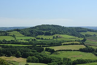
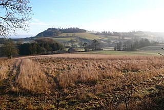
Eggardon Hill is a prehistoric hillfort on a hill in Dorset, England. It is located on chalk uplands approximately four miles to the east of the town of Bridport.

The Kymin,, is a hill overlooking Monmouth, in Monmouthshire, Wales. It is located approximately one mile east of Monmouth, on the eastern side of the River Wye and adjacent to the border with the Forest of Dean and England. The summit of the hill, about 800 feet above sea level, is known for its neo-classical monuments, the Roundhouse and the Naval Temple, built between 1794 and 1800. The site is within a designated Area of Outstanding Natural Beauty (AONB) and is owned by the National Trust.

Hardown Hill is a hill between Ryall and Morcombelake in the county of Dorset, England. It rises west of the South Dorset Downs, close to the Dorset coast, and overlooks the Marshwood Vale to the north. Its prominence qualifies it as one of Dorset's four Marilyns and it is listed as one of the "top 12 Dorset views to take your breath away" by Dorset's official tourist website.
Lambert's Castle Hill rises between the villages of Marshwood and Fishpond Bottom in the county of Dorset, England. It is part of the South Dorset Downs and its prominence qualifies it as one of the so-called HuMPs.

Ridgeway Hill, also referred to as Grange Hill or Steeple Hill, is the third highest point of the Purbeck Hills in the county of Dorset standing at 199 metres (653 ft), is one of the only hills with a prominence of over a hundred metres, HuMPs, in the county. Near the top of the hill is an 18th-century folly known as Grange Arch, built by the former owner of Creech Grange, Denis Bond. On the eastern spur of the hill is Stonehill Down which is now a nature reserve. There are also good views of Swyre Head on the Jurassic Coast.
Toller Down is one of the highest hills in the county of Dorset, England. It stands 252 metres high and is just 200 metres west of the main A356 road from Dorchester to Crewkerne. It is part of the Dorset Downs. Its prominence of just under 100 metres classifies it as a sub-HuMP.
At 248 metres (814 ft), Dogbury Hill is one of the highest hills in the county of Dorset, England. It is the site of a prehistoric hill fort.

Creech Barrow Hill is a steep, conical hill, 193 metres (633 ft) high, near the coast of Dorset, England, and the highest point of the Dorset Heaths. It has been described as "one of Dorset's most distinctive landmarks." Geologically, it is also the highest Cenozoic hill in England.

Weston Hill is a hill, 250 metres (820 ft) high, on the A 356, 1 kilometre west of Corscombe in the county of Dorset in southern England. It is located within the Dorset Downs. It is named after the hamlet of Weston to the northeast.

The Stonehill Down Nature Reserve is a downland nature reserve on the Purbeck Hills in the county of Dorset, England. It is managed by the Dorset Wildlife Trust.