
The West Highland Way is a linear long-distance route in Scotland. It is 154 km long, running from Milngavie north of Glasgow to Fort William in the Scottish Highlands, with an element of hill walking in the route. The trail, which opened in 1980, was Scotland's first officially designated Long Distance Route, and is now designated by NatureScot as one of Scotland's Great Trails. It is primarily intended as a long distance walking route, and whilst many sections are suitable for mountain biking and horseriding there are obstacles and surfaces that will require these users to dismount in places.
Glen Coe is a glen of volcanic origins, in the Highlands of Scotland. It lies in the north of the county of Argyll, close to the border with the historic province of Lochaber, within the modern council area of Highland. The glen is noted for its scenic beauty.

Meall a' Bhùiridh (IPA:[ˈmauɫ̪ˈaˈvuːɾʲɪʝ]) is a mountain on the edge of Rannoch Moor in the Highlands of Scotland. It lies near the top of Glen Coe and Glen Etive, overlooking the Kings House Hotel inn and the A82 road. The Glencoe Ski area is located on the northern slopes of the peak.

Sgùrr a' Mhàim is a Scottish mountain situated 5.5 kilometres (3.4 mi) north north-west of Kinlochleven in the Lochaber region of the Highland area.

The Mamores are a group of mountains in the Lochaber area of the Grampian Mountains in the Scottish Highlands. They form an east–west ridge approximately fifteen kilometres in length lying between Glen Nevis to the north and Loch Leven to the south.

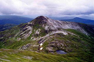
Mullach nan Coirean is a Scottish mountain situated in the Mamores group of hills. It reaches a height of 939 metres (3081 feet) and is located eight kilometres north-west of Kinlochleven. It is the most westerly of the ten Munros in the Mamores and it is connected to the adjoining mountain of Stob Bàn by a bealach with a height of 846 metres; these two Munros are often climbed together from Glen Nevis. The mountain's name translates from the Gaelic as Summit of the Corries or Top of the Corries and this is quite fitting as Mullach nan Coirean has four corries on its slopes. Mullach can also mean a "roof". However it is unusual that the name does not include reference to the mountain's distinct red tinge cause by its red granite rock.
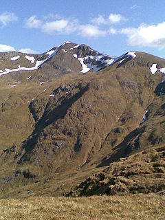
Stob Bàn is a mountain situated in the Lochaber region of Highland, Scotland, 16 kilometres east of Fort William. It reaches a height of 977 metres (3205 feet) and lies in a group of hills known as the Grey Corries which includes three other Munros and nine Munro "Tops" along an eight kilometre ridge. The mountain's name translate as “White Peak”, while other sources give the translation as Light Coloured Peak with the hill being covered in light coloured schist scree, in contrast to the rest of the Grey Corries which are made up of grey quartzite scree. The mountain is a prominent conical shape, isolated from the rest of the group and distant from any main roads. It should not be confused with another Munro named Stob Bàn situated in the Mamores.

Stob Coire Easain is a Scottish Munro mountain which reaches a height of 1115 metres (3658 feet), situated 18 kilometres east of Fort William. It stands on the western side of Loch Treig, along with its "twin", the Munro Stob a' Choire Mheadhoin. Collectively the pair are called "The Easains" or the "Stob Corries" and stand just one kilometre apart connected by a high col with an approximate height of 965 metres. The fine corrie of Coire Easain Beag lies in between the two mountains facing north west. Stob Coire Easain’s name translates from the Gaelic as “Peak of the Corrie of the Little Waterfall”. This mountain should not be confused with another Stob Coire Easain, a Munro “Top” on the Munro Stob Coire an Laoigh

Sròn a’ Choire Ghairbh is a Scottish mountain situated on the northern side of Loch Lochy, 13 kilometres north of Spean Bridge in the Highland Council area.

Stob Ghabhar is a Scottish mountain nine kilometres (5.6 mi) north west of Bridge of Orchy. It is part of the Black Mount group of mountains and stands on the border of the Argyll and Bute and Highland council areas.

Meall na Teanga is a Scottish mountain located in the Highland council area, 11 km (7 mi) north of Spean Bridge.

Stob a' Choire Odhair is a Scottish mountain situated eight kilometres north west of Bridge of Orchy on the border of the Argyll and Bute and Highland council areas.

Creise is a Scottish mountain that stands at the eastern end of Glen Coe, just to the south of the A82 road, some 26 kilometres South-southeast of Fort William in the Highland Council area. The mountain was previously known as Clach Leathad in the Munro Tables prior to 1981, its name being changed to Creise when the highest point was found to be 1200 metres further north along the summit ridge when using new mapping techniques.

Stob Choire Claurigh is a Scottish mountain situated 16 km (10 mi) east of Fort William in the Lochaber district of the Highland council area. It is part of one of the best ridge walks on the Scottish mainland.

Stob a' Choire Mheadhoin is a mountain in the Scottish Highlands, it is situated 19 km east of Fort William in the Lochaber area of the Highland council area.
The Grey Corries are a range of mountains in the West Highlands of Scotland. The range includes several of Scotland's highest peaks including a number of Munros. The range is bounded to the north by the great extent of Leanachan Forest beyond which is Glen Spean and the Great Glen, to the east by the defile of Lairig Leacach and to the south by upper Glen Nevis and the headwaters of the Abhainn Rath. The ridge continues westwards at a high level to join Aonach Beag, Aonach Mor, Carn Mor Dearg and Ben Nevis.
Mullach Fraoch-choire is a 1,102-metre (3,615 ft) mountain – a Munro – in the Northwest Highlands of Scotland on a ridge extending north for 8 kilometres (5.0 mi) between Loch Cluanie in Glenmoriston and upper Glen Affric. It is within the Glen Affric National Scenic Area and Glen Affric National Nature Reserve.

Lurg Mhòr is a remote 986-metre (3,235 ft) mountain, a Munro, in the Northwest Highlands of Scotland at the high point of an east–west range of hills comprising Meall Mor, Lurg Mhòr and Bidein a' Choire Sheasgaich.

Ben Nevis and Glen Coe is a national scenic area (NSA) covering part of the Highlands of Scotland surrounding Ben Nevis and Glen Coe, in which certain forms of development are restricted. It is one of 40 such areas in Scotland, which are defined so as to identify areas of exceptional scenery and to ensure its protection from inappropriate development. The Ben Nevis and Glen Coe NSA covers 903 km2 (349 sq mi) of land, lying within the Highland, Argyll and Bute and Perth and Kinross council areas. A further 19 km2 (7.3 sq mi) of the NSA are marine, covering the sea loch of Loch Leven.
