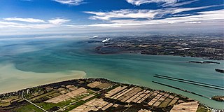
The Detroit River flows west and south for 24 nautical miles from Lake St. Clair to Lake Erie as a strait in the Great Lakes system. The river divides the metropolitan areas of Detroit, Michigan, and Windsor, Ontario—an area collectively referred to as Detroit–Windsor—and forms part of the border between Canada and the United States. The Ambassador Bridge, the Detroit–Windsor Tunnel, and the Michigan Central Railway Tunnel connect the cities.

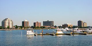
Windsor is a city in southwestern Ontario, Canada, on the south bank of the Detroit River directly across from Detroit, Michigan, United States. Geographically located within but administratively independent of Essex County, it is the southernmost city in Canada and marks the southwestern end of the Quebec City–Windsor Corridor. The city's population was 229,660 at the 2021 census, making it the third-most populated city in Southwestern Ontario, after London and Kitchener. The Detroit–Windsor urban area is North America's most populous trans-border conurbation. Linking the Great Lakes Megalopolis, the Ambassador Bridge border crossing is the busiest commercial crossing on the Canada–United States border.
Sarnia is a city in Lambton County, Ontario, Canada. It had a 2021 population of 72,047, and is the largest city on Lake Huron. Sarnia is located on the eastern bank of the junction between the Upper and Lower Great Lakes where Lake Huron flows into the St. Clair River in the Southwestern Ontario region, which forms the Canada–United States border, directly across from Port Huron, Michigan.
Essex County is a primarily rural county in Southwestern Ontario, Canada comprising seven municipalities: Amherstburg, Kingsville, Lakeshore, LaSalle, Leamington, Tecumseh and the administrative seat, Essex.

Chatham-Kent is a single-tier municipality in Southwestern Ontario, Canada. It is mostly rural, and its population centres are Chatham, Wallaceburg, Tilbury, Blenheim, Ridgetown, Wheatley and Dresden. The current Municipality of Chatham-Kent was created in 1998 by the amalgamation of Blenheim, Bothwell, Camden, the City of Chatham, the Township of Chatham, Dover, Dresden, Erie Beach, Erieau, Harwich, Highgate, Howard, Orford, Raleigh, Ridgetown, Duart, Thamesville, Tilbury East, Tilbury, Wallaceburg, Wheatley and Zone.

The Ambassador Bridge is a tolled international suspension bridge across the Detroit River that connects Detroit, Michigan, United States, with Windsor, Ontario, Canada. Opened in 1929, it is the busiest international border crossing in North America in terms of trade volume, carrying more than 25% of all merchandise trade between the United States and Canada by value. A 2004 Border Transportation Partnership study showed that 150,000 jobs in the Detroit–Windsor region and US$13 billion in annual production depend on the Detroit–Windsor international border crossing.

Pugwash is an incorporated village in Cumberland County, Nova Scotia, Canada, located on the Northumberland Strait at the mouth of the Pugwash River. It had a population of 746 as of the 2021 census. The name Pugwash is derived from the Mi'kmaq word Pakwesk, meaning "a shoal", in reference to a reef near the mouth of the harbour.

Exmoor is loosely defined as an area of hilly open moorland in west Somerset and north Devon in South West England. It is named after the River Exe, the source of which is situated in the centre of the area, two miles north-west of Simonsbath. Exmoor is more precisely defined as the area of the former ancient royal hunting forest, also called Exmoor, which was officially surveyed 1815–1818 as 18,810 acres (7,610 ha) in extent. The moor has given its name to a National Park, which includes the Brendon Hills, the East Lyn Valley, the Vale of Porlock and 55 km (34 mi) of the Bristol Channel coast. The total area of the Exmoor National Park is 692.8 km2 (267.5 sq mi), of which 71% is in Somerset and 29% in Devon.

The Humber River is a river in Southern Ontario, Canada. It is in the Great Lakes Basin, is a tributary of Lake Ontario and is one of two major rivers on either side of the city of Toronto, the other being the Don River to the east. It was designated a Canadian Heritage River on September 24, 1999.

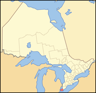
Southern Ontario is a primary region of the Canadian province of Ontario. It is the most densely populated and southernmost region in Canada, with approximately 13.5 million people, approximately 36% of Canada's population of 37 million. The region lies south of the province's other primary region, Northern Ontario, although the exact northern boundary of Southern Ontario is disputed. However, its core region is situated south of Algonquin Park, the latter being in an area of transition between coniferous forest north of the French and Mattawa Rivers and southern deciduous forest. It covers between 14 and 15% of the province, depending on the inclusion of the Parry Sound and Muskoka districts which also lie in the transitional area between northern and southern forest regions. Southern Ontario differs greatly from Northern Ontario, having a much higher population density, a different climate, and a different culture than its northern counterpart. It is broken into smaller subregions, including Central Ontario, Eastern Ontario, the Golden Horseshoe, and Southwestern Ontario.

Goose Creek State Park is a North Carolina state park near Washington, Beaufort County, North Carolina in the United States. It covers 1,672 acres (6.77 km2) just off of Pamlico Sound, in North Carolina's Coastal Plain. Goose Creek State Park is home to a wide variety of wildlife that make their homes in the extensive salt water marshes, inlets and creeks on the northern side of the sound. Goose Creek State Park is open for year-round recreation, east of Washington, two miles (3 km) south of U.S. Route 264 on Camp Leach Road.

Goderich is a town in the Canadian province of Ontario and is the county seat of Huron County. The town was founded by John Galt and William "Tiger" Dunlop of the Canada Company in 1827. First laid out in 1828, the town is named after Frederick John Robinson, 1st Viscount Goderich, who was prime minister of the United Kingdom at the time. It was incorporated as a town in 1850.

Kellyville is a suburb of Sydney, in the state of New South Wales, Australia 36 kilometres north-west of the Sydney central business district in the local government area of The Hills Shire. It is part of the Hills District region.

Marpole, originally a Musqueam village named c̓əsnaʔəm, is a mostly residential neighbourhood of 23,832 in 2011, located on the southern edge of the city of Vancouver, British Columbia, immediately northeast of Vancouver International Airport, and is approximately bordered by Angus Drive to the west, 57th Avenue to the north, Ontario Street to the east and the Fraser River to the south. It has undergone many changes in the 20th century, with the influx of traffic and development associated with the construction of the Oak Street Bridge and the Arthur Laing Bridge.

Dresden is an agricultural community in southwestern Ontario, Canada, part of the municipality of Chatham-Kent. It is located on the Sydenham River. The community is named after Dresden, Germany. The major field crops in the area, by both acreage and production, are grain corn, soybean, and winter wheat. The main horticultural crop is tomatoes, followed by sweet corn and carrots.

Fort Malden, formally known as Fort Amherstburg, is a defence fortification located in Amherstburg, Ontario. It was built in 1795 by Great Britain in order to ensure the security of British North America against any potential threat of American invasion. Throughout its history, it is most known for its military application during the War of 1812 as Sir Isaac Brock and Tecumseh met here to plan the Siege of Detroit. It was the British stronghold during the war and is now a National Historic Site of Canada. The fort also had an important role in securing Upper Canada's border with Detroit during the Upper Canada Rebellion.
Windsor, Ontario, has a very diverse population, and this diversity is shown in its many neighbourhoods. Windsor has twenty in all, ranging from rural farmland to densely built-up areas.

Berczy Village is a residential neighbourhood in Markham, Ontario, Canada. It is bounded to the north by Major Mackenzie Drive, to the east by McCowan Road, to the south by 16th Avenue, and to the west by Kennedy Road. This area is north of Unionville. The community is named after William Berczy, Markham's founder. The name can be found on limestone plaques throughout the community's many arterial road entrances.

Wood Street Village is a clustered and linear village in Surrey, England with a village green, buffered by Metropolitan Green Belt on all sides. It is centred 3 miles (4.8 km) west of Guildford and is part of the civil parish of Worplesdon, as well as continuing to be served semi-dependently as a chapelry of the Church of England.
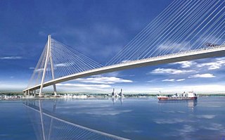
The Gordie Howe International Bridge, known during development as the Detroit River International Crossing and the New International Trade Crossing, is a cable-stayed international bridge across the Detroit River, currently under construction. The crossing will connect Detroit, United States of America and Windsor, Canada by linking Interstate 75 in Michigan with Highway 401 in Ontario. The bridge will provide uninterrupted freeway traffic flow, as opposed to the current configuration with the nearby Ambassador Bridge that connects to city streets on the Ontario side. The bridge is named after Canadian ice hockey player Gordie Howe, whose celebrated career included 25 years with the Detroit Red Wings, and who died two years before construction began.

