Black Point (Livingston Island)

Last updated
Location of Ioannes Paulus II Peninsula on Livingston Island in the South Shetland Islands Ioannes-Paulus-II-Peninsula-location-map.PNG
Location of Ioannes Paulus II Peninsula on Livingston Island in the South Shetland Islands
Black Point and Porlier Bay from Cape Shirreff, with Tangra Mountains in the background Tangra-Mountains-from-Cape-Shirreff.png
Black Point and Porlier Bay from Cape Shirreff, with Tangra Mountains in the background
Black Point in the background (on the right, with Cape Shirreff behind it) from Catalunyan Saddle; Burdick Ridge in the foreground Sandanski.jpg
Black Point in the background (on the right, with Cape Shirreff behind it) from Catalunyan Saddle; Burdick Ridge in the foreground
Topographic map of Livingston Island Livingston-Island-Map-2010-15.png
Topographic map of Livingston Island

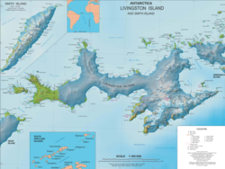
Black Point is a rocky promontory of 38 hectares (94 acres) [1] projecting 800 m northwards from the northeast coast of Ioannes Paulus II Peninsula into Hero Bay, Livingston Island in the South Shetland Islands, Antarctica to form the east side of the entrance to Porlier Bay. The area was visited by early 19th century sealers.

Contents

The name of the point is a descriptive one. Fortín Rock is a sea stack lying off Black Point.

Location

The point is located at 62°29′09.7″S60°42′57.6″W / 62.486028°S 60.716000°W / -62.486028; -60.716000 which is 4.8 km southeast of Cape Shirreff, 18.3 km west-southwest of Desolation Island, 15.88 km west-northwest of Siddins Point, 10 km north-northwest of Avitohol Point, 6.3 km north by west of Agüero Point and 3 km north by west of Sandanski Point. British mapping in 1968, Chilean in 1971, Argentine in 1980, Spanish in 1991, and Bulgarian in 2005 and 2009.

Map

Notes

  1. L.L. Ivanov. Antarctica: Livingston Island and Greenwich, Robert, Snow and Smith Islands. Scale 1:120000 topographic map. Troyan: Manfred Wörner Foundation, 2009. ISBN   978-954-92032-6-4

Related Research Articles

<span class="mw-page-title-main">Emona Anchorage</span>

Emona Anchorage is a roughly square embayment, the internal part of South Bay, Livingston Island in the South Shetland Islands, Antarctica used as an anchorage for ships visiting the Bulgarian base St. Kliment Ohridski.

<span class="mw-page-title-main">Kaliakra Glacier</span> Glacier in Antarctica

Kaliakra Glacier is a glacier in northeastern Livingston Island, Antarctica extending 3.8 nautical miles in east-west direction and 4.3 nautical miles in north-south direction, and situated southeast of Saedinenie Snowfield, southwest of Panega Glacier, north of Struma Glacier and upper Huron Glacier, and northeast of Perunika Glacier. It is bounded by Melnik Ridge and Bowles Ridge to the south, by Hemus Peak, Gurev Gap, Gleaner Heights, Elhovo Gap, Leslie Hill, Leslie Gap and Radnevo Peak to the west, and Miziya Peak and Samuel Peak to the north. The glacier drains eastwards into Moon Bay south of Perperek Knoll and north of Sindel Point.

<span class="mw-page-title-main">Magura Glacier</span> Glacier in Antarctica

Magura Glacier on the southeast side of Tangra Mountains on Livingston Island in the South Shetland Islands, Antarctica is located to the north of M'Kean Point, northeast of Srebarna Glacier, south of Iskar Glacier and southwest of Dobrudzha Glacier. It is bounded by Great Needle Peak to the west, Vitosha Saddle, Vihren Peak and Helmet Peak to the northwest, Plovdiv Peak and Shishman Peak to the north, and Devin Saddle and Kuber Peak to the northeast. The glacier extends 3.5 km in southwest-northeast direction and 1.9 km in northwest-southeast direction, and flows southeastward into Bransfield Strait.

<span class="mw-page-title-main">Pimpirev Glacier</span> Glacier on Livingston Island, South Shetland Islands, Antarctica

Pimpirev Glacier on Livingston Island in the South Shetland Islands, Antarctica is situated south of the glacial divide between the Drake Passage and Bransfield Strait, southeast of Tundzha Glacier, southwest of Saedinenie Snowfield, west of Perunika Glacier and east-northeast of Kamchiya Glacier. The feature extends 5.5 km in a southeast-northwest direction, and 1.8 km in northwest-southeast direction. The glacier drains southeastwards towards Pimpirev Beach, mostly terminating on the shore, and on several occasions penetrating the South Bay waters east-northeast of Ereby Point.

<span class="mw-page-title-main">Prespa Glacier</span> Glacier in Antarctica

Prespa Glacier on Rozhen Peninsula, Livingston Island in the South Shetland Islands, Antarctica is situated east-northeast of Tarnovo Ice Piedmont, east of the head of Charity Glacier, southeast of Ruen Icefall and southwest of Macy Glacier. It is bounded to the east by Needle Peak and Ludogorie Peak, to the northwest by St. Cyril Peak and St. Methodius Peak, and to the southwest by Shumen Peak and Yambol Peak, and flows southeastward into Bransfield Strait between Gela Point and Samuel Point. The feature extends 3.5 km in east-west direction and 2.5 km in north-south direction. The glacier is named after Prespa Peak in the Rhodope Mountains, Bulgaria.

<span class="mw-page-title-main">Teres Ridge</span>

Teres Ridge is a ridge of elevation 330 m extending 2 km in north-south direction and 1.2 km in east-west direction near Siddins Point on the Hero Bay coast of Livingston Island in the South Shetland Islands, Antarctica surmounting Tundzha Glacier to the southwest and Saedinenie Snowfield to the southeast and east. Ice-free northeastern and northern slopes.

<span class="mw-page-title-main">Tundzha Glacier</span> Glacier in Antarctica

Tundzha Glacier is a glacier on Livingston Island in the South Shetland Islands, Antarctica situated east-southeast of Berkovitsa Glacier, west of Saedinenie Snowfield, northwest of Pimpirev Glacier, north of Kamchiya Glacier and east-northeast of Verila Glacier. It is bounded by Snow Peak to the west, Teres Ridge to the east and the glacial divide between the Drake Passage and Bransfield Strait to the south. The glacier extends 7.5 nautical miles in east-west direction and 2.4 nautical miles in the north-south direction, and drains northwards into Hero Bay between Avitohol Point and Siddins Point.

<span class="mw-page-title-main">Urdoviza Glacier</span> Glacier in Antarctica

Urdoviza Glacier is a glacier on western Livingston Island in the South Shetland Islands, Antarctica situated east of the northern portion of Etar Snowfield and north of Medven Glacier. It extends 1.5 nautical miles in the east-west direction and 1.5 nautical miles in the north-south direction, and is bounded by the eastern slopes of Oryahovo Heights and draining eastwards into Stoyanov Cove of Hero Bay between Agüero Point and Sandanski Point. Bulgarian mapping in 2005 and 2009.

<span class="mw-page-title-main">Varna Peninsula</span> Peninsula in Antarctica

Varna Peninsula is a roughly rectangular predominantly ice-covered peninsula forming the northeast extremity of Livingston Island in the South Shetland Islands, Antarctica. It is bounded by Hero Bay to the northwest, by Moon Bay to the southeast, and by McFarlane Strait to the northeast.

<span class="mw-page-title-main">Berkovitsa Glacier</span> Glacier in Antarctica

Berkovitsa Glacier is a glacier on Livingston Island, Antarctica situated east of Etar Snowfield, south of Medven Glacier, west-northwest of Tundzha Glacier and north-northeast of Verila Glacier. It is bounded by the southeastern slopes of Oryahovo Heights and the northwestern slopes of Snow Peak. It extends 4 km in southeast-northwest direction and 2.8 km in northwest-southeast direction, and drains northeastwards into Hero Bay between Avitohol Point and Remetalk Point.

<span class="mw-page-title-main">Desolation Island (South Shetland Islands)</span> Island in Antarctica

Desolation Island is one of the minor islands in the South Shetlands archipelago, Antarctica situated at the entrance to Hero Bay, Livingston Island. The island is V-shaped with its northern coast indented by Kozma Cove. Surface area 3.12 square kilometres (1.20 sq mi).

<span class="mw-page-title-main">Elemag Reef</span>

Elemag Reef is the 100 m long in southeast-northwest direction and 40 m wide moraine reef in Moon Bay, Livingston Island in the South Shetland Islands, with a narrow shoal extending for over 400 m eastwards. Surface area 0.33 ha. Situated 5.4 km south-southwest of Edinburgh Hill, 5.95 km west of Half Moon Island, 5.18 km northwest of Rila Point, 3.3 km northeast of Zlatograd Rock and 1.85 km east-southeast of Sindel Point. Formed at the terminus of merging Struma and Huron Glaciers, it was originally named Elemag Point. The current reef configuration is due to glacier retreat of up to 1.8 km in the area in the late 20th and early 21st century. Bulgarian mapping in 2009. Bulgarian topographic survey Tangra 2004/05 and mapping in 2009.

<span class="mw-page-title-main">Hespérides Point</span>

Hespérides Point is a rocky point of land projecting into South Bay north-northwest of Johnsons Dock, Livingston Island in the South Shetland Islands, Antarctica and forming the southwest side of the entrance to Emona Anchorage. Surmounted by Hesperides Hill. The area was visited by 19th century sealers operating from nearby Johnsons Dock.

<span class="mw-page-title-main">Contell Glacier</span> Glacier in Antarctica

Contell Glacier is 1.2 nmi long and 0.4 nautical miles wide glacier on Hurd Peninsula, Livingston Island in the South Shetland Islands, Antarctica bounded by Atlantic Club Ridge to the northwest, Krum Rock to the north, Balkan Snowfield to the northeast, and Charrúa Ridge and Charrúa Gap to the south. It is crescent-shaped, running northwestwards in its upper course, then between Charrúa Ridge and Krum Rock turning west-southwestwards to flow into South Bay north of Johnsons Dock.

<span class="mw-page-title-main">Rotch Dome</span>

Rotch Dome is the sloping ice dome rising to 360 m immediately east of Byers Peninsula, and between Barclay Bay and Walker Bay in Livingston Island, South Shetland Islands, Antarctica. It is bounded by Urvich Wall to the west, surmounting Ivanov Beach to the northwest, Etar Snowfield to the north-northeast and Verila Glacier to the east-northeast, and is linked by a saddle to Casanovas Peak to the northeast.

<span class="mw-page-title-main">Craggy Island (Livingston Island)</span>

Craggy Island is a narrow island marked by crags, lying in Hero Bay, Livingston Island in the South Shetland Islands, Antarctica and forming the northeast side of Blythe Bay. Its surface area is 9 hectares .) The area was frequented by early nineteenth century English and American sealers operating from Blythe Bay.

<span class="mw-page-title-main">Cape Danger</span>

Cape Danger is the rocky point forming the northwest extremity of the ice-free Desolation Island situated in the entrance to Hero Bay, Livingston Island in the South Shetland Islands, Antarctica. The cape forms the west side of the entrance to Kozma Cove. The area was visited by early 19th century sealers operating from nearby Blythe Bay.

<span class="mw-page-title-main">Burel Hill</span> Ice-free hill on Desolation Island

Burel Hill is an ice-free hill rising 152 metres (499 ft) in the northwest part of Desolation Island off Livingston Island in the South Shetland Islands, Antarctica. It surmounts Kozma Cove to the east, and Hero Bay to the south and southwest.

<span class="mw-page-title-main">Vodoley Rock</span> Rock in the South Shetland Islands, Antarctica

Vodoley Rock is the rock extending 220 m (720 ft) in northwest–southeast direction and 110 m (360 ft) wide in Barclay Bay on the west side of Ioannes Paulus II Peninsula on Livingston Island in the South Shetland Islands, Antarctica. The area was visited by early 19th century sealers operating on nearby Byers Peninsula and Cape Shirreff.

<span class="mw-page-title-main">Mihaylovski Cove</span>

Mihaylovski Cove is the 5 km wide cove indenting for 1.3 km the northwest coast of South Bay in Livingston Island, Antarctica that is entered west of Ereby Point and east of Lukovo Point, and has its head fed by Kamchiya Glacier. The area was known to early 19th century sealers who operated from nearby Johnsons Dock. The feature is named after the brothers Petar Mihaylovski, physician at St. Kliment Ohridski base during the 2007/08 and subsequent seasons, and Hristo Mihaylovski, engineer in the national Antarctic campaign during 2015/16 and subsequent seasons.

References