Phoenixville is a borough in Chester County, Pennsylvania, United States. It is located 28 miles (45 km) northwest of Philadelphia at the junction of French Creek and the Schuylkill River. It is in the Philadelphia metropolitan area. According to a 2021 estimate, the population was 19,029. As noted by Forbes, Phoenixville is a former beaten-down mill town with a recent downtown revitalization plan that led to 10 craft breweries, a distillery, and winery tasting rooms.

Upper Providence Township is a township in Montgomery County, Pennsylvania, United States. As of the 2010 census, the township population was 21,219.

Bonneville Lock and Dam consists of several run-of-the-river dam structures that together complete a span of the Columbia River between the U.S. states of Oregon and Washington at River Mile 146.1. The dam is located 40 miles (64 km) east of Portland, Oregon, in the Columbia River Gorge. The primary functions of Bonneville Lock and Dam are electrical power generation and river navigation. The dam was built and is managed by the United States Army Corps of Engineers. At the time of its construction in the 1930s it was the largest water impoundment project of its type in the nation, able to withstand flooding on an unprecedented scale. Electrical power generated at Bonneville is distributed by the Bonneville Power Administration. Bonneville Lock and Dam is named for Army Capt. Benjamin Bonneville, an early explorer credited with charting much of the Oregon Trail. The Bonneville Dam Historic District was designated a National Historic Landmark District in 1987.

The Schuylkill River is a river running northwest to southeast in eastern Pennsylvania. The river was improved by navigations into the Schuylkill Canal, and several of its tributaries drain major parts of Pennsylvania's Coal Region. It flows for 135 miles (217 km) from Pottsville to Philadelphia, where it joins the Delaware River as one of its largest tributaries.

The Union Canal was a towpath canal that existed in southeastern Pennsylvania in the United States during the 19th century. First proposed in 1690 to connect Philadelphia with the Susquehanna River, it ran approximately 82 mi from Middletown on the Susquehanna below Harrisburg to Reading on the Schuylkill River.
The Gatun Dam is an earthen dam across the Chagres River in Panama, near the town of Gatun. The dam, constructed between 1907 and 1913, is a crucial element of the Panama Canal; it impounds the artificial Gatun Lake, which carries ships 33 kilometres (21 mi) of their transit across the Isthmus of Panama. In addition, a hydro-electric generating station at the dam generates electricity which is used to operate the locks and other equipment in the canal.

Melton Hill Dam is a hydroelectric dam on the Clinch River just south of Oak Ridge, Tennessee, United States. The dam is operated by the Tennessee Valley Authority, which built the dam in the early 1960s to extend the Tennessee Valley's continuous navigation channel up the Clinch as far as Clinton and to increase TVA's overall power-generating capacity. The dam impounds the 5,470-acre (2,210 ha) Melton Hill Lake, and is the only TVA tributary dam serviced by a navigation lock. The dam and associated infrastructure were listed on the National Register of Historic Places in 2017.
The Main Line of Public Works was a package of legislation passed by the Commonwealth of Pennsylvania in 1826 to establish a means of transporting freight between Philadelphia and Pittsburgh. It funded the construction of various long-proposed canal and road projects, mostly in southern Pennsylvania, that became a canal system and later added railroads. Built between 1826 and 1834, it established the Pennsylvania Canal System and the Allegheny Portage Railroad.
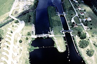
The Okeechobee Waterway or Okeechobee Canal is a relatively shallow artificial waterway in the United States, stretching across Florida from Fort Myers on the west coast to Stuart on Florida's east coast. The waterway can support tows such as barges or private vessels up to 50 feet wide x 250 feet long which draw less than 10 feet, as parts of the system, especially the locks may have low water depths of just ten feet. The system of channels runs through Lake Okeechobee and consists of the Caloosahatchee River to the west of the lake and the St. Lucie Canal east of the lake.
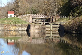
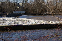
The Schuylkill Canal, or Schuylkill Navigation, was a system of interconnected canals and slack-water pools along the Schuylkill River in the U.S. state of Pennsylvania, built as a commercial waterway in the early 19th-century. Chartered in 1815, the navigation opened in 1825, to provide transportation and water power.

This is a list of properties and districts listed on the National Register of Historic Places in Pennsylvania. As of 2015, there are over 3,000 listed sites in Pennsylvania. All 67 counties in Pennsylvania have listings on the National Register.

The Conowingo Dam is a large hydroelectric dam in the lower Susquehanna River near the town of Conowingo, Maryland. The medium-height, masonry gravity dam is one of the largest non-federal hydroelectric dams in the U.S., and the largest dam in the state of Maryland.

The Schuylkill River Trail is a multi-use trail along the banks of the Schuylkill River in southeastern Pennsylvania. Partially complete as of 2018, the trail is ultimately planned to run about 140 miles (230 km) from the river's headwaters in Schuylkill County to Fort Mifflin in Philadelphia.
Mont Clare is a village in Upper Providence Township, Montgomery County, Pennsylvania. The village is located on the left bank of the Schuylkill River opposite Phoenixville and Chester County. Mont Clare is at the site of the former Jacobs' ford. Mont Clare hosts the only functional lock and one of only two remaining watered stretches of the Schuylkill Canal. Mont Clare was the birthplace of the infamous outlaw Sundance Kid.

The Lehigh Canal is a navigable canal that begins at the mouth of Nesquehoning Creek on the Lehigh River in the Lehigh Valley and Northeastern regions of Pennsylvania. It was built in two sections over a span of 20 years beginning in 1818. The lower section spanned the distance between Easton and present-day Jim Thorpe. In Easton, the canal met the Delaware and Morris Canals, which allowed anthracite coal and other goods to be transported further up the U.S. East Coast. At its height, the Lehigh Canal was 72 miles (116 km) long.
The Pennsylvania Canal, sometimes known as the Pennsylvania Canal system, was a complex system of transportation infrastructure improvements, including canals, dams, locks, tow paths, aqueducts, and viaducts. The canal was constructed and assembled over several decades beginning in 1824, the year of the first enabling act and budget items.

Fricks Locks Historic District or more simply Frick's Lock is an abandoned village, along the also abandoned Schuylkill Canal, in the northeast portion of East Coventry Township, Chester County, Pennsylvania. This 18th-century village outlasted the canal, being abandoned in the late 20th century with the construction of the adjacent Limerick Nuclear Power Plant. The village on about 18 acres of land were listed as a historic district by the National Register of Historic Places in 2003. Frick's Locks is considered a modern ghost town and, although private property, attracts visitors.

Starved Rock Lock and Dam, also known as Lock and Dam No. 6, is a lock and dam facility managed by the U.S. Army Corps of Engineers along the Illinois River. It is part of the Illinois Waterway and was constructed between 1926 and 1933. The lock and dam was added to the National Register of Historic Places as the Starved Rock Lock and Dam Historic District in 2004.

Thomson Dam, also known as the Thomson Hydro Station or Thomson Water Project, is an embankment and concrete gravity dam on the Saint Louis River near the town of Thomson in northeastern Minnesota, United States. It consists of a 1600-foot long primary structure and multiple supplementary dams which, together with precambrian rock outcrops known as the Thomson formation, impound the river to create Thomson Reservoir.