A parkway is a landscaped thoroughfare. The term is particularly used for a roadway in a park or connecting to a park from which trucks and other heavy vehicles are excluded.

Horace William Shaler Cleveland was an American landscape architect. His approach to natural landscape design can be seen in projects such as the Grand Rounds in Minneapolis; Sleepy Hollow Cemetery in Concord, Massachusetts; the boulevard system in Omaha, Nebraska; Roger Williams Park in Providence, Rhode Island; and St. Anthony Park in Saint Paul, Minnesota.

Frederick Law Olmsted Jr. was an American landscape architect and city planner known for his wildlife conservation efforts. He had a lifetime commitment to national parks, and worked on projects in Acadia, the Everglades and Yosemite National Park. He gained national recognition by filling in for his father on the Park Improvement Commission for the District of Columbia beginning in 1901, and by contributing to the famous McMillan Commission Plan for redesigning Washington according to a revised version of the original L’Enfant plan. Olmsted Point in Yosemite and Olmsted Island at Great Falls of the Potomac River in Maryland are named after him.

Roger Williams Park is an elaborately landscaped 427-acre (173 ha) city park in Providence, Rhode Island and a historic district listed on the National Register of Historic Places. The park is named after Roger Williams, the founder of the city of Providence and the primary founder of the state of Rhode Island.

Warren Henry Manning was an American landscape designer and promoter of the informal and naturalistic "wild garden" approach to garden design. In his designs, Manning emphasized pre-existing flora through a process of selective pruning to create a "spatial structure and character." An advocate for the conservation of the American landscape, Manning was a key figure in the formation of the American Society of Landscape Architects and a proponent of the National Park System.

Blackstone is a predominantly residential neighborhood in Providence, Rhode Island. It is in the northeast corner of the city and is bounded to the south and west by Lloyd Avenue and Hope Street respectively. It is one of six neighborhoods comprising the East Side of Providence.

College Hill is a historic neighborhood of Providence, Rhode Island, and one of six neighborhoods comprising the city's East Side. It is roughly bounded by South and North Main Street to the west, Power Street to the south, Governor Street and Arlington Avenue to the east and Olney Street to the north. The neighborhood's primary commercial area extends along Thayer Street, a strip frequented by students in the Providence area.

Fox Point is a neighborhood in the East Side of Providence, Rhode Island. It is bounded by the Providence and Seekonk rivers, Interstate 195 and the College Hill and Wayland neighborhoods. Fox Point is the southernmost neighborhood in the East Side area of Providence.

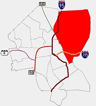
The East Side is a collection of neighborhoods in the eastern part of the city of Providence, Rhode Island. It officially comprises the neighborhoods of Blackstone, Hope, Mount Hope, College Hill, Wayland, and Fox Point.

Elmhurst is a primarily residential neighborhood in the northwest quadrant of Providence, Rhode Island. Douglas Avenue and Admiral Street bound Elmhurst to the northeast, Academy Avenue and Smith Street bound it to the west, while Chalkstone Avenue marks the southern border.

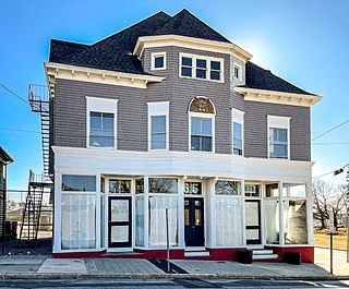
The Oddfellows' Hall is an historic fraternal society building on Warren Avenue in East Providence, Rhode Island.
The Blackstone Boulevard Realty Plat Historic District is a historic district roughly bounded by Blackstone Blvd., Rochambeau Ave., Holly St. and Elmgrove Ave. in Providence, Rhode Island.

Blackstone Park Historic District is roughly bounded by the Seekonk River, Laurell Avenue, Blackstone Boulevard, and South Angell Street in Providence, Rhode Island within the Blackstone neighborhood of the East Side.

Constance Witherby Park is an historic park at 210 Pitman Street, Wayland, Providence, Rhode Island. It was added to the National Register of Historic Places in 1975.

The Freeman Plat Historic District is a residential historic district on the East Side of Providence, Rhode Island. The district is a well-preserved example of an early-20th-century planned residential area, encompassing some 50 acres (20 ha). It is roughly bounded by Sessions Street, Morris Avenue, Laurel Avenue, and Wayland Avenue, and consists of a network of generously-landscaped winding roads, laid out in consultation with the Olmsted Brothers design firm. The houses built are generally of high quality, many of them architect-designed, with architecturally diverse revival styles popular at the time. The area was developed between 1916 and 1929 by John Freeman, who owned a country estate in the area, and sought a way to develop the largely swampy tract.

The Wayland Historic District is a predominantly residential historic district on the east side of Providence, Rhode Island. It is a large area, covering about 122 acres (49 ha), bounded roughly on the north by Everett and Laurel Avenues, on the east by Blackstone Boulevard and Butler Avenue, on the west by Arlington Avenue, and on the south by Angell and South Angell Streets. This area, which was in the 19th century part of the Moses Brown farm, was platted for development in 1891, with most of the construction taking place in the early decades of the 20th century. Most of the residential properties in the district are single-family houses, typically built in revival styles popular at the time. They are set on similarly sized lots with fairly uniform setbacks, and were typically built without garages. There are a number of two-family houses, and a small number of apartment buildings, most of which are found on the arterial roads of the area. There are several religious buildings, including several churches; the most architecturally distinctive religious building is the Jewish Temple Beth El, built 1951–54.
Domenic Thomas Russillo, AIA (1902-1980), was a minor American architect who practiced in mid-20th-century Rhode Island and Massachusetts.

Alfred Stone was an American Architect. He was a founding partner of the Providence, Rhode Island, firm of Stone, Carpenter & Willson. Mr. Stone was best known for designing many prominent Rhode Island buildings, including the Providence Public Library, Union Station, buildings at Brown University and the University of Rhode Island, and many private homes.

The Blackstone Park Conservation District is a public, 45-acre woodland conservation area on the East Side of Providence, Rhode Island. It is run by the non-profit Blackstone Parks Conservancy in partnership with the Providence Parks Department. The park is situated on the west bank of the tidal Seekonk River, the northernmost part of Narragansett Bay tidewater. The park lies within the watershed and wildlife corridor of the Blackstone River Valley. Unlike many city parks, it is actively managed as a preserve for the purpose of providing habitats for wildlife and supporting a healthy ecosystem for native flora and fauna.


