Related Research Articles

Flinders Chase National Park is a protected area in the Australian state of South Australia located at the west end of Kangaroo Island about 177 kilometres west-south west of the state capital of Adelaide and 110 kilometres west of the municipal seat of Kingscote. It is a sanctuary for endangered species and home to a few geological phenomena. It was the second national park to be declared in South Australia.

Lincoln National Park is a protected area in the Australian state of South Australia located about 249 kilometres (155 mi) west of the state capital of Adelaide and about 9.5 kilometres (5.9 mi) south of the municipal seat of Port Lincoln. It consists of a mainland area on the Jussieu Peninsula on the south eastern tip of Eyre Peninsula and a number of nearby islands. The national park contains significant sites of natural, indigenous and early European heritage.

Cape Leeuwin is the most south-westerly mainland point of the Australian continent, in the state of Western Australia.

Augusta is a town on the south-west coast of Western Australia, where the Blackwood River emerges into Flinders Bay. It is the nearest town to Cape Leeuwin, on the furthest southwest corner of the Australian continent. In the 2001 census it had a population of 1,091; by 2016 the population of the town was 1,109.
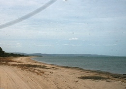
Bathurst Bay is a bay in the localities of Lakefield and Starcke in the Shire of Cook, Queensland, Australia. In the 19th century it was the base for the pearling fleet. It is now a tourist attraction on Cape York Peninsula in northern Queensland, Australia, near the Great Barrier Reef.
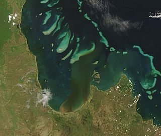
Princess Charlotte Bay is a large bay on the east coast of Far North Queensland at the base of Cape York Peninsula, 350 km north northwest of Cairns. Princess Charlotte Bay is a part of the Great Barrier Reef Marine Park and it is a habitat for the dugong.
St Alouarn Islands are a group of islands and rocks south-east of Cape Leeuwin in Western Australia, approximately 11 km south of Augusta in Flinders Bay.

The Blackwood River is a major river and catchment in the South West of Western Australia.
Denham Island is part of the Great Barrier Reef Marine Park at the tip of Cape Melville, Queensland in Bathurst Bay.
Maclear Island is part of the Great Barrier Reef Marine Park at the tip of Cape Melville, Queensland in Bathurst Bay.

Flinders Island is the name given to an island that forms part of the Great Barrier Reef Marine Park at the tip of Cape Melville, Queensland in Bathurst Bay. The original indigenous name was Wurriima.

Stanley Island is part of the Great Barrier Reef Marine Park at the tip of Cape Melville, Queensland in Bathurst Bay. It is located North of Denham Island and Flinders Island in the Flinders Group National Park in Princess Charlotte Bay. The island is a popular tourist destination with fine anchorage between the islands and along various coastal stretches. Stanley Island was first declared a national park in 1939.
King Island is part of the Great Barrier Reef Marine Park at the tip of Cape Melville, Queensland in Bathurst Bay.
Clack Island is part of the Great Barrier Reef Marine Park at the tip of Cape Melville, Queensland in Bathurst Bay, Australia.

Investigator Strait is a body of water in South Australia lying between the Yorke Peninsula, on the Australian mainland, and Kangaroo Island. It was named by Matthew Flinders after his ship, HMS Investigator, on his voyage of 1801–1802. It is bordered by the Gulf St Vincent in the northeast.

Captain Matthew Flinders was an English navigator and cartographer who led the first inshore circumnavigation of the landmass that is now known as Australia. He is also credited as being the first person to utilise the name Australia to describe the entirety of that continent including Van Diemen's Land, a title he regarded as being "more agreeable to the ear" than previous names such as Terra Australis.

Port Davey is an oceanic inlet located in the south west region of Tasmania, Australia.

Wreck Island is a small coral cay. It is located near the Tropic of Capricorn in the southern Great Barrier Reef, 93 km due north east of Gladstone, Queensland, Australia, and 460 km north of the state capital Brisbane.

Hardy Inlet is an inlet that is located in the South West region of Western Australia.
The Walmbaria are an indigenous Australian people of Cape York Peninsula in northern Queensland.
References
| This Queensland protected areas related article is a stub. You can help Wikipedia by expanding it. |