A storm surge, storm flood, tidal surge, or storm tide is a coastal flood or tsunami-like phenomenon of rising water commonly associated with low-pressure weather systems, such as cyclones. It is measured as the rise in water level above the normal tidal level, and does not include waves.

Cape York Peninsula is a large peninsula located in Far North Queensland, Australia. It is the largest unspoiled wilderness in northern Australia. The land is mostly flat and about half of the area is used for grazing cattle. The relatively undisturbed eucalyptus-wooded savannahs, tropical rainforests and other types of habitat are now recognised and preserved for their global environmental significance. Although much of the peninsula remains pristine, with a diverse repertoire of endemic flora and fauna, some of its wildlife may be threatened by industry and overgrazing as well as introduced species and weeds.

Magnetic Island is an island 8 kilometres (5 mi) offshore from the city of Townsville, Queensland, Australia. This 52 km2 (20.1 sq mi) mountainous island in Cleveland Bay has effectively become a suburb of Townsville, with 2,335 permanent residents. The island is accessible from Townsville Breakwater to Nelly Bay Harbour by ferry. There is a large 39.5 km2 (15.3 sq mi) National Park and bird sanctuary and walking tracks can be taken between the populated bays and to a number of tourist destinations such as the World War II forts.

Yeppoon is a coastal town and locality in the Shire of Livingstone, Queensland, Australia. Yeppoon is renowned for its beaches, tropical climate, and the islands out on the bay. Twenty-five minutes from the city of Rockhampton, Yeppoon is the principal town on the Capricorn Coast, a string of seaside communities stretching more than 150 kilometres (93 mi) from north to south. The beaches and shallow coves provide a destination both for tourists and retirees settling down in Central Queensland. Offshore, there are 27 islands including Great Keppel Island which is 20 kilometres (12 mi) from Yeppoon.

Thursday Island, colloquially known as TI, or in the Kawrareg dialect, Waiben or Waibene, is an island of the Torres Strait Islands, an archipelago of at least 274 small islands in the Torres Strait. TI is located approximately 39 kilometres north of Cape York Peninsula in Far North Queensland, Australia. Thursday Island is also the name of the town in the south and west of the island and also the name of the locality which contains the island within the Shire of Torres. The town of Rose Hill is located on the north-eastern tip of the island.

Mission Beach is a coastal town and locality in the Cassowary Coast Region, Queensland, Australia. In the 2016 census, the locality of Mission Beach had a population of 815 people.

Palm Island is a locality consisting of an island group of 16 islands, split between the Shire of Hinchinbrook and the Aboriginal Shire of Palm Island, in Queensland, Australia. The locality coincides with the geographical entity known as the Palm Island group, also known as the Greater Palm group, originally named the Palm Isles. In the 2016 census, Palm Island had a population of 2,455 people.
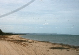
Cyclone Mahina was the deadliest cyclone in recorded Australian history, and also likely the most intense tropical cyclone ever recorded in the Southern Hemisphere. Mahina struck Bathurst Bay, Cape York Peninsula, Queensland, on 4 March 1899, and its winds and enormous storm surge combined to kill more than 300 people.
Princess Charlotte Bay is a large bay on the east coast of Far North Queensland at the base of Cape York Peninsula, 350 km north northwest of Cairns. Princess Charlotte Bay is a part of the Great Barrier Reef Marine Park and it is a habitat for the dugong.
The history of Darwin details the city's growth from a fledgling settlement into a thriving colonial capital and finally a modern city.

Severe storms in Australia refers to the storms, including cyclones, which have caused severe damage in Australia. For comparison, a comprehensive list of all damaging storms can be found on the Australian Bureau of Meteorology website.

Far North Queensland (FNQ) is the northernmost part of the Australian state of Queensland. Its largest city is Cairns and it is dominated geographically by Cape York Peninsula, which stretches north to the Torres Strait, and west to the Gulf Country. The waters of Torres Strait include the only international border in the area contiguous with the Australian mainland, between Australia and Papua New Guinea.
The following lists events that happened during 1899 in Australia.

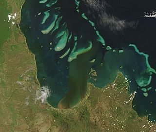
Severe Tropical Cyclone Monica was the most intense tropical cyclone, in terms of maximum sustained winds, on record to impact Australia. The 17th and final storm of the 2005–06 Australian region cyclone season, Monica originated from an area of low pressure off the coast of Papua New Guinea on 16 April 2006. The storm quickly developed into a Category 1 cyclone the next day, at which time it was given the name Monica. Travelling towards the west, the storm intensified into a severe tropical cyclone before making landfall in Far North Queensland, near Lockhart River, on 19 April 2006. After moving over land, convection associated with the storm quickly became disorganised.

Cooktown is a coastal town and locality in the Shire of Cook, Queensland, Australia. Cooktown is at the mouth of the Endeavour River, on Cape York Peninsula in Far North Queensland where James Cook beached his ship, the Endeavour, for repairs in 1770. Both the town and Mount Cook which rises up behind the town were named after James Cook.

Severe Tropical Cyclone Kathy was a powerful tropical cyclone that devastated the Sir Edward Pellew Group of Islands in March 1984. Originating from a tropical low off the southern coast of Papua New Guinea. Tracking westward, the system attained gale-force winds by 18 March before striking the Cape York Peninsula. After crossing the area, Kathy entered the Gulf of Carpentaria where environmental conditions favoured significant development. On 22 March, the storm attained its peak intensity as a Category 5 severe tropical cyclone with ten-minute sustained winds of 205 km/h (125 mph). By this time, the storm had been tracking towards the southwest and struck the Sir Edward Pellew Group of Islands later on 22 March before moving over the Australian mainland as a slightly weaker system. Once over land, Kathy rapidly degraded, losing gale-force winds within 24 hours; the storm dissipated over the Northern Territory on 24 March.

The Colony of Queensland was a colony of the British Empire from 1859 to 1901, when it became a State in the federal Commonwealth of Australia on 1 January 1901. At its greatest extent, the colony included the present-day State of Queensland, the Territory of Papua and the Coral Sea Islands Territory.

Severe Tropical Cyclone Althea was a powerful tropical cyclone that devastated parts of North Queensland just before Christmas 1971. One of the strongest storms ever to affect the Townsville area, Althea was the fourth system and second severe tropical cyclone of the 1971–72 Australian region cyclone season. After forming near the Solomon Islands on 19 December and heading southwest across the Coral Sea, the storm reached its peak intensity with 10-minute average maximum sustained winds of 130 km/h (80 mph) – Category 3 on the Australian cyclone scale. At 09:00 AEST on Christmas Eve, Althea struck the coast of Queensland near Rollingstone, about 50 km (30 mi) north of Townsville. Although early weather satellites provided only occasional glimpses into the cyclone's formative stages, its landfall was monitored closely by land-based radar that depicted an ongoing eyewall replacement cycle. Althea produced copious rainfall over central and western Queensland as it turned toward the southeast, and on 26 December the cyclone emerged over open waters. After briefly re-intensifying, the system dissipated on 29 December.