
Campton is a town in Grafton County, New Hampshire, United States. The population was 3,343 at the 2020 census. Campton, which includes the villages of Blair, Campton Hollow, Lower Campton and West Campton, is home to Blair State Forest and Livermore Falls State Forest. It is located in the foothills of the White Mountains, and parts of the White Mountain National Forest are in the northeast and northwest.

The White Mountains Region is a tourism region designated by the New Hampshire Division of Travel and Tourism. It is located in northern New Hampshire in the United States and is named for the White Mountains, which cover most of the region. The southern boundary of the region begins at Piermont on the west, and runs east to Campton, then on to Conway and the Maine border. The northern boundary begins at Littleton and runs east to Gorham and the Maine border. The region to the north is known as the Great North Woods Region, which should not be confused with the larger and more general Great North Woods.

New Hampshire Route 49 is a 11.297-mile-long (18.181 km) east–west state highway in Grafton County, within the White Mountains in central New Hampshire. It runs from Campton to Waterville Valley, and serves mainly to allow traffic to access the Waterville Valley Resort ski area.

The Cornish–Windsor Covered Bridge is a 158-year-old, two-span, timber Town lattice-truss, interstate, covered bridge that crosses the Connecticut River between Cornish, New Hampshire, and Windsor, Vermont. Until 2008, when the Smolen–Gulf Bridge opened in Ohio, it had been the longest covered bridge in the United States.
The Hillsgrove Covered Bridge is a Burr arch truss covered bridge over Loyalsock Creek in Hillsgrove Township, Sullivan County, in the U.S. state of Pennsylvania. It was built c. 1850 and is 186 feet (56.7 m) long. In 1973, it became the first covered bridge in the county to be placed on the National Register of Historic Places (NRHP). The bridge is named for the township and nearby unincorporated village of Hillsgrove, and is also known as Rinkers Covered Bridge for an adjoining farm.
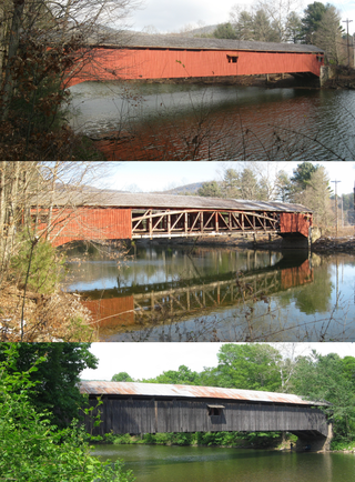
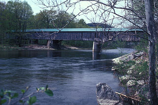
Blair Bridge may refer to:
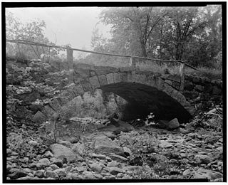
Five Stone Arch Bridges is a cluster of stone arch bridges in Hillsborough, New Hampshire, United States that have been designated as a National Historic Civil Engineering Landmark by the American Society of Civil Engineers.
The Slate Covered Bridge is a wooden covered bridge which carries the Westport Village Road over the Ashuelot River in Westport, a village of Swanzey, New Hampshire. The bridge was built in 2001, as a replacement for an 1862 bridge that was destroyed by arson fire in 1993. The 1862 bridge, one of New Hampshire's small number of surviving 19th-century covered bridges, was listed on the National Register of Historic Places in 1978.

The Bement Covered Bridge is a historic wooden covered bridge on Center Road over the Warner River in Bradford, New Hampshire. A Long-truss bridge, it was built in 1854, and is one of New Hampshire's small number of surviving 19th-century covered bridges. It was listed on the National Register of Historic Places in 1976.
The Haverhill–Bath Covered Bridge is a historic covered bridge over the Ammonoosuc River joining Bath and Woodsville, New Hampshire. Formerly used to carry New Hampshire Route 135, the bridge was idled in 1999. Restored in 2004, it is now open to foot traffic only. It is believed to be the oldest covered bridge in the state.

The Contoocook Railroad Bridge is a covered bridge on the former Contoocook Valley Railroad line spanning the Contoocook River in the center of the village of Contoocook, New Hampshire, United States. It is referred to in the National Register of Historic Places as the Hopkinton Railroad Covered Bridge, for the town of Hopkinton, New Hampshire, in which the village of Contoocook is located.

The Capon Lake Whipple Truss Bridge, formerly known as South Branch Bridge or Romney Bridge, is a historic Whipple truss bridge in Capon Lake, West Virginia. It is located off Carpers Pike and crosses the Cacapon River. The bridge formerly carried Capon Springs Road over the river, connecting Capon Springs and Capon Lake.

The Wells River Bridge between Wells River, Vermont and Woodsville, New Hampshire, is a steel double-decked Baltimore truss bridge over the Connecticut River. It was built in 1903 to carry rail and road traffic.
Scott Covered Bridge is a covered bridge spanning the West River in Townshend, Vermont. Built in 1870, it is at 277 feet (84 m) one of the longest covered bridges in the state, exhibiting three different forms of support: a Town lattice truss, kingpost trusses, and laminated arches. The bridge was listed on the National Register of Historic Places in 1973. It is closed to all traffic.

The Otway Covered Bridge, in Scioto County, Ohio north of Ohio State Route 348 in Otway, was built in 1874 by the Smith Bridge Co. of Toledo, Ohio. It was listed on the National Register of Historic Places in 1974.


