Blanket Bay is a small bay on the coast of Victoria, Australia. The foreshore is part of the Cape Otway National park.
Contents

Blanket Bay is a small bay on the coast of Victoria, Australia. The foreshore is part of the Cape Otway National park.

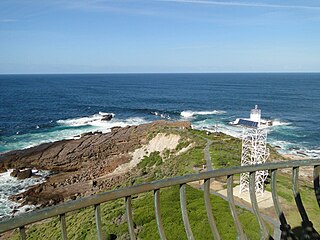
The bay's beach is protected by rock platforms and outer reefs. The bay is surrounded by steep sloping Manna Gum forests and rugged rock and reef coastline. The sandy beach being about 200 metres long. [1] [2] A creek flows into the beach
The area adjacent to the bay is a camping ground and linked by hiking trails of the Great Ocean Walk.
Remains of the 1880s jetty built for landing supplies can still be seen at low tide. [3]
In 1846, a number of Gadubanud aboriginal people where massacred in a revenge expedition, after a member of an early colonial surveying party was killed.
In 1877 a road gang was landed at the bay to construct a track to the Cape Otway lighthouse. Parker River was previously used to delivery provisions to the lighthouse but was deemed too treacherous. [4]
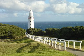
Blanket Bay was once a unloading point for stores arriving by ship to supply the Cape Otway lighthouse that is six kilometers away. [5] It was used for three decades. [3]
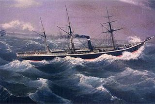
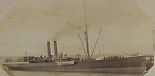
In 1896, three mariners (chief officer Mr. Griffiths, able seaman Mathieson, and casual hand Thomas Monk died in rough surf when their boat capsized while coming ashore at Blanket Bay. The Government steamer Lady Loch had left Melbourne port of Williamstown and had docked at Apollo Bay before attempting to deliver six months of provisions for the lighthouse keepers. [6]

The Great Ocean Road is an Australian National Heritage-listed 240-kilometre (150 mi) stretch of road along the south-eastern coast of Australia, between the Victorian towns of Torquay and Allansford. Built by returned soldiers between 1919 and 1932, and dedicated to soldiers killed during World War I, the road is the world's largest war memorial. Winding through varying terrain along the coast, and providing access to several prominent landmarks, including the Twelve Apostles limestone stack formations, the road is an important tourist attraction.

The Great Otway National Park is a national park located in the Barwon South West region of Victoria, Australia. The 103,185-hectare (254,980-acre) national park is situated approximately 162 kilometres (101 mi) southwest of Melbourne, in the Otway Ranges, a low coastal mountain range. It contains a diverse range of landscapes and vegetation types.

Port Phillip or Port Phillip Bay is a horsehead-shaped enclosed bay on the central coast of southern Victoria, Australia. The bay opens into the Bass Strait via a short, narrow channel known as The Rip, and is completely surrounded by localities of Victoria's two largest cities — metropolitan Greater Melbourne in the bay's main eastern portion north of the Mornington Peninsula, and the city of Greater Geelong in the much smaller western portion north of the Bellarine Peninsula. Geographically, the bay covers 1,930 km2 (750 sq mi) and the shore stretches roughly 264 km (164 mi), with the volume of water around 25 km3 (6.0 cu mi). Most of the bay is navigable, although it is extremely shallow for its size — the deepest portion is only 24 m (79 ft) and half the bay is shallower than 8 m (26 ft). Its waters and coast are home to seals, whales, dolphins, corals and many kinds of seabirds and migratory waders.

The Shire of Colac Otway is a local government area in the Barwon South West region of Victoria, Australia, located in the south-western part of the state. It covers an area of 3,438 square kilometres (1,327 sq mi) and in June 2018 had a population of 21,503. It includes the towns of Apollo Bay, Beeac, Beech Forest, Birregurra, Colac, Cressy, Forrest, Johanna, Kennett River, Lavers Hill, Warrion and Wye River. It came into existence on 23 September 1994 through the amalgamation of the local government areas of City of Colac, Shire of Colac, part of the Shire of Otway and part of the Shire of Heytesbury.

The Loch Ard Gorge is part of Port Campbell National Park, Victoria, Australia, about three minutes' drive west of The Twelve Apostles.

The Argus was an Australian daily morning newspaper in Melbourne from 2 June 1846 to 19 January 1957, and was considered to be the general Australian newspaper of record for this period. Widely known as a conservative newspaper for most of its history, it adopted a left-leaning approach from 1949. The Argus's main competitor was David Syme's more liberal-minded newspaper, The Age.

Loch Ard was an iron-hulled clipper ship that was built in Scotland in 1873 and wrecked on the Shipwreck Coast of Victoria, Australia in 1878.
Cape Otway is a cape and a bounded locality of the Colac Otway Shire in southern Victoria, Australia on the Great Ocean Road; much of the area is enclosed in the Great Otway National Park. The cape marks the boundary between the Southern Ocean on the west and Bass Strait on the east.

Green Cape is a locality situated on the eponymous headland or cape on the far south coast of New South Wales. It is located at 37° 15' S 150° 03' E, within Beowa National Park, south of Eden, New South Wales. The headland forms the northern boundary of Disaster Bay.

The Great Ocean Walk is a walking trail on Victoria's southwest coast in Australia, traversing several areas of historical and cultural significance. The track makes extensive usage of eco-friendly facilities; with Parks Victoria and tour guide operators attempting to raise environmental awareness. The trail meanders along high cliff tops and sandy beaches.

SS Admella was an Australian passenger steamship that was shipwrecked off the coast of the colony of South Australia in 1859. It broke up after striking a submerged reef near Cape Banks, off the coast near Carpenter Rocks, southwest of Mount Gambier, in the early hours on 6 August 1859. Survivors clung to the wreck for over a week and many people took days to die as they glimpsed the land from the sea and watched as one rescue attempt after another failed.

SS Alert was a steamship that sank off Cape Schanck, Victoria, Australia on 28 December 1893. The ship was built for the gentle waters of Scottish lochs and was almost 51 m (167 ft) long and weighed 247 tonnes.

The Shire of Otway was a local government area about 190 kilometres (118 mi) southwest of Melbourne, the state capital of Victoria, Australia. The shire covered an area of 1,906.94 square kilometres (736.3 sq mi), and existed from 1919 until 1994.
David Hastie "Bud" Adamson was an Australian rules footballer who played for South Melbourne in the Victorian Football League (VFL).
Jack Kenneth Loney was an amateur Australian maritime historian who published over one hundred books and numerous newspaper and magazine articles. He was a schoolteacher and principal until his retirement. He became interested in maritime history after preparing several general history booklets covering the Otway region of western Victoria, Australia.

Cape Otway Lighthouse is a lighthouse on Cape Otway in southern Victoria, Australia. It is Victoria's oldest working lighthouse. During winter to spring, the lighthouse is a vantage point for land-based whale watching as migrating whales swim very close to shores.

Cape Banks is a headland in the Australian state of South Australia located in the gazetted locality of Carpenter Rocks at the south end of Bucks Bay and the north end of Bungaloo Bay on the state's south east coast about 36 kilometres west south west of the city of Mount Gambier.
Wongarra is a coastal locality in the Shire of Colac Otway, Victoria, Australia. In the 2016 census, Wongarra had a population of 37.
The Record was a weekly newspaper published in South Melbourne, Victoria, from 1869 to at least 1954, serving Port Melbourne, Albert Park, Middle Park, and Garden City.