
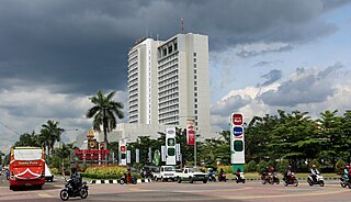
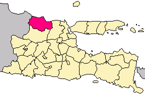
Wonosobo Regency is a regency in Central Java province in Indonesia. The regency seat is located in the town of Wonosobo, located at 7.3684940°S 109.8983841°E,on the Dieng Plateau, about 120 km from Semarang City. Wonosobo Regency shares borders with Temanggung and Magelang Regencies to the east, Purworejo Regency to the south, Kebumen Regency and Banjarnegara Regency to the west, and Batang Regency and Kendal Regency to the north. The regency's area is 984.68 km2 and its population was 754,883 at the 2010 census and 879,124 at the 2020 census; the official estimate as at mid 2023 was 909,664.

In Indonesia, village or subdistrict is the fourth-level subdivision and the smallest administrative division of Indonesia below a district, regency/city, and province. Similar administrative divisions outside of Indonesia include barangays in the Philippines, Muban in Thailand, civil townships and incorporated municipalities in the United States and Canada, communes in France and Vietnam, dehestan in Iran, hromada in Ukraine, Gemeinden in Germany, comuni in Italy, or municipios in Spain. The UK equivalent are civil parishes in England and communities in Wales. There are a number of names and types for villages in Indonesia, with desa being the most frequently used for regencies, and kelurahan for cities or for those communities within regencies which have town characteristics. According to the 2019 report by the Ministry of Home Affairs, there are 8,488 urban villages and 74,953 rural villages in Indonesia. North Aceh Regency contained the highest number of rural villages (852) amongst all of the regencies of Indonesia, followed by Pidie Regency with 730 rural villages and Bireuen Regency with 609 rural villages. Prabumulih, with only 12 rural villages, contained the fewest. Counted together, the sixteen regencies of Indonesia containing the most rural villages—namely, North Aceh (852), Pidie (730), Bireuen (609), Aceh Besar (604), Tolikara (541), East Aceh (513), Yahukimo (510), Purworejo (469), Lamongan (462), South Nias (459), Kebumen (449), Garut (421), Bojonegoro (419), Bogor (416), Cirebon (412), and Pati (401)—contain one-third of all the rural villages in Indonesia. Five of these are located in Aceh, two in Highland Papua, three in Central Java, two in East Java, three in West Java, and one in North Sumatra. An average number of rural villages in the regencies and 15 cities of Indonesia is 172 villages. A village is the lowest administrative division in Indonesia, and it is the lowest of the four levels. The average land area of villages in Indonesia is about 25.41 km2 (9.81 sq mi), while its average population is about 3,723 people.

Klaten Regency is a regency in Central Java province in Indonesia. It covers an area of 701.52 km2 and had a population of 1,130,047 at the 2010 Census and 1,260,506 at the 2020 Census; the official estimate as at mid 2023 was 1,284,386. Its administrative centre is in the town of the same name; the town extends over 35.85 km2 to encompass three of the regency's districts, with a combined total of 135,681 inhabitants in mid 2023; a fourth district (Kalikotes) is part of its urban area.
Boyolali is a regency in the eastern part of Central Java province in Indonesia. It covers an area of 1,015.10 km2, and had a population of 930,531 at the 2010 census and 1,062,713 at the 2020 census; the official estimate as at mid 2023 was 1,090,131, comprising 547,713 males and 542,416 females. The administrative centre is the town of Boyolali.

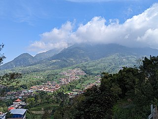
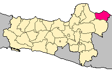
Magelang is a regency in Central Java, Indonesia, famous for its 9th century Buddhist temple of Borobudur. Its capital is Mungkid. It covers an area of 1,085.73 km2 and had a population of 1,181,723 at the 2010 Census and 1,299,859 at the 2020 Census; the official estimate as at mid 2023 was 1,330,656. These figures exclude the autonomous city of Magelang, which is separately administered but is geographically enclaved within the regency, which borders Temanggung Regency to the north, Semarang Regency to the northeast, Boyolali Regency to the east, the Special Region of Yogyakarta to the south and southeast, Purworejo Regency to the southwest, and Wonosobo Regency to the west.

Jember Regency is a regency of East Java province, in Indonesia. The land area is 3,314.13 km2, and the population was 2,332,726 at the 2010 census and 2,536,729 at the 2020 Census; the official estimate as at mid 2023 was 2,600,663. Its administrative capital is the urban area of Jember, which with 366,932 inhabitants in mid 2023 is the third largest urban area in East Java province but does not have municipality or city status as it is split between three separate administrative districts (kecamatan). Jember is famous for its tobacco farms and traditional food called tape which is made of fermented cassava.

Magetan Regency is a regency (kabupaten) of East Java Province, Indonesia. It is an inland regency, and lies in the west of the province, adjoining Central Java Province. It covered an area of 688.84 km2 and had a population of 620,442 at the 2010 Census and 670,812 at the 2020 Census; the official estimate as at mid-2023 was 691,618. The administrative headquarters is in the town of Magetan.

Nganjuk Regency is a regency (kabupaten) of East Java Province, Indonesia. It borders Bojonegoro Regency in the north, Jombang Regency in the east, Kediri Regency in the south and Madiun Regency in the west. It covers an area of 1,224.33 sq. km, and had a population of 1,017,030 at the 2010 Census and 1,103,902 at the 2020 Census; the official estimate as of mid-2023 was 1,144,508. The administrative centre of the regency is the town of Nganjuk. The current regent is Dr. Drs. H. Marhaen Djumadi, S.E., S.H., M.M., M.B.A.

Sumenep, officially the Sumenep Regency, was previously spelled as Samanap or Zamanap in English, is a regency of the East Java province, Indonesia. It has an area of 2,093.47 square kilometres and the population of 1,142,210 as of 2023. The administrative capital is Kota Sumenep. Since 2014, Sumenep Regency has been recognized by UNESCO as the area that has the most Mpu in the world and most of them are in Aeng Tong-Tong Village, Saronggi District.
Sukoharjo Regency is a regency in the Central Java province in Indonesia. It covers an area of 493.23 km2 and had a population of 824,238 at the 2010 Census and 907,587 at the 2020 Census; the official estimate as of mid-2023 was 932,680. Its administrative centre is in the town of Sukoharjo, about 10 km south of Surakarta. This regency is bordered by the city of Surakarta in the north, Karanganyar Regency in the east, Wonogiri Regency and Yogyakarta in the south as well as Klaten Regency in the west. The regency is part of the metropolitan zone of Surakarta, which is known as Subosukawonosraten.

North Hulu Sungai Regency is one of the regencies in the Indonesian province of South Kalimantan. It was created on 26 June 1959 from the trifurcation of the original Hulu Sungai Regency and formerly covered a much larger area in the north of the province, but on 14 July 1965 the northern districts were split off to create a separate Tabalong Regency, and on 25 February 2003 the eastern districts were split off to create a separate Balangan Regency. It now has a land area of 907.72 km2, and had a population of 209,246 at the 2010 Census and 226,727 at the 2020 Census; the official estimate as of mid-2023 was 233,412. The capital of the regency is the town of Amuntai.

Serang is a city and the capital of Banten province and was formerly also the administrative center of Serang Regency in Indonesia. The city is located towards the north of Banten province, on the island of Java; the north part of the city contains the coast zone facing onto Banten Bay, and includes the historical site of Old Banten, after which the province is named. Before Banten province was formed in 2000, Serang city was part of West Java province.
Rembang Regency is a regency on the extreme northeast coast of Central Java Province, on the island of Java in Indonesia. The regency covers an area of 1,036.70 km2 on Java, and it had a population of 591,359 at the 2010 Census and 645,333 at the 2020 Census; the official estimate as of mid-2023 was 660,166, of whom 331,870 were males and 328,296 were females. Its administrative capital is the town of Rembang.

Paser Regency is the southernmost regency (kabupaten) within the East Kalimantan province of Indonesia. It was created in 1959, originally spelt "Pasir Regency", but renamed "Paser" in 2007; however its northeastern districts were split off on 10 April 2002 to form the new Penajam North Paser Regency. The residual regency covers an area of 11,603.94 km2, and it had a population of 230,316 at the 2010 Census and 275,452 at the 2020 Census; the official estimate as at mid-2023 was 303,424. Its administrative centre is the town of Tana Paser.

Kapuas Regency is one of the thirteen regencies which divide Central Kalimantan Province, on the island of Kalimantan, Indonesia. It formerly covered a wider area, but on 10 April 2002 two further regencies were cut out of its western districts, and the residual area is now 17,070.39 km.2 Its population was 329,646 at the 2010 Census and 410,446 at the 2020 Census; the official estimate as at mid 2023 was 425,186. The administrative centre is the town of Kuala Kapuas near the coast, but the largest town is Selat, which includes 8 of the regency's 15 urban kelurahan, and had 72,382 inhabitants in mid 2023.

Bone Regency is a regency of South Sulawesi province of Indonesia. Originally the seat of the Bone state, it joined Indonesia in 1950. The regency covers an area of 4,559.00 km2 and had a population of 717,682 at the 2010 census and 801,775 at the 2020 census. The official estimate of population as of mid-2023 was 820,510. Its main products are seaweed, rice, and fish. The administrative centre is the town of Watampone, which comprises the three districts of Tanete Riattang Barat, Tanete Riattang, and Tanete Riattang Timur within the regency.

South Minahasa Regency is a regency in North Sulawesi, Indonesia. Its capital is the town of Amurang. It was originally part of the Minahasa Regency until it was established as a separate regency on 25 February 2003. In turn, nearly four years later, a new Southeast Minahasa Regency was established as a separate regency from part of the South Minahasa Regency on 2 January 2007. The residual Regency now covers an area of 1,456.74 km2, and had a population of 195,553 at the 2010 Census; this had risen to 236,463 at the 2020 Census; the official estimate as at mid 2023 was 244,590.

Southeast Minahasa Regency is a regency in North Sulawesi, Indonesia. It covers a land area of 730.63 km2, and had a population of 100,443 at the 2010 Census; this had risen to 116,323 at the 2020 Census, and the official estimate as at mid 2023 was 118,946. It was established as a separate regency from the south-eastern part of the South Minahasa Regency on 2 January 2007. Its administrative centre is at the town of Ratahan.
Tuban Regency is a regency in the East Java province of Indonesia. The Dutch name of the regency is 'Toeban'. It covers a land area of 1,839.94 sq. km, and had a population of 1,118,464 at the 2010 Census and 1,198,012 at the 2020 Census; the official estimate as of mid-2023 was 1,258,368. The administrative centre is the coastal town of Tuban.

Gresik Regency is a regency within East Java Province of Indonesia. As well as a large part of the northern and western suburbs of the city of Surabaya, it includes the offshore Bawean Island, some 125 km to the north of Java and Madura. Almost a third of the Gresik Regency's area is the coastal area; the Districts in this zone are Kebomas District, Gresik District, Manyar District, Bungah District, and Ujungpangkah District.
