Related Research Articles

Star City is a city in, and the county seat of, Lincoln County, Arkansas, United States. Incorporated in 1876, the city is located between the Arkansas Delta and Arkansas Timberlands. With an economy historically based on agriculture, today Star City has developed a diverse economy based on both industry and agriculture. As of the 2010 census, the population was 2,274. Star City is located within the Pine Bluff metropolitan area.

Young Harris is a city in Towns County, Georgia, United States. The population was 899 at the 2010 census. Young Harris is home to Young Harris College, after which it was named.

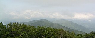
Brasstown Bald is the highest point in the U.S. state of Georgia. It is located in the northeastern part of the state in the Blue Ridge Mountains on the border between Towns and Union counties south of the city of Hiawassee. The mountain is known to the native Cherokee people as Enotah.
North Georgia is the northern hilly/mountainous region in the U.S. state of Georgia. At the time of the arrival of settlers from Europe, it was inhabited largely by the Cherokee. The counties of north Georgia were often scenes of important events in the history of Georgia. It was the site of many American Civil War battles, including the Battle of Lookout Mountain and the Battle of Chickamauga, leading up to the Atlanta Campaign. Today, particularly in the northeast portion of the region, tourism sustains the local economy.

The Russell–Brasstown Scenic Byway is a National Scenic Byway in the U.S. state of Georgia that includes parts of Georgia State Route 17 (SR 17), SR 75, SR 180, and SR 75 Alternate, as well as the entire length of SR 348.
Rocky Knob is a name used to describe eight different mountain peaks located in the North Georgia mountains that are scattered among four different Georgia counties.

The Duncan Ridge Trail is a hiking trail that has been designated as a National Recreation Trail in Georgia. The trail is 35.5 miles (53.25 km.) long and traverses mountains, descends into valleys and features scenic viewpoints and waterfalls. It is located in the Chattahoochee National Forest and is maintained by the U.S. Forest Service in the Brasstown and Toccoa Ranger Districts.

The Arkaquah Trail is a hiking trail that has been designated as a National Recreation Trail in Georgia. The trail is 5.5 miles (8.25 km) long and is located in the Chattahoochee National Forest in the Brasstown Ranger District. The trail is managed by the U.S. Forest Service.

Jacks Knob Trail is a hiking trail that has been designated as a National Recreation Trail in Georgia, US. The trail is 4.5 miles (7.2 km) long and is located in the Chattahoochee National Forest in the Brasstown Ranger District. The trail is managed by the U.S. Forest Service.

Locust Log Ridge refers to two different mountain ridges located within the State of Georgia.
Behlola is a town and union council of Charsadda District in Khyber Pakhtunkhwa province of Pakistan. It is located at 34°15'8N 71°50'33E and has an altitude of 327 metres.
Adams Station was a stagecoach stop and hotel in Del Norte County, California. It was located on the Smith River just west of Gasquet, at an elevation of 338 feet.
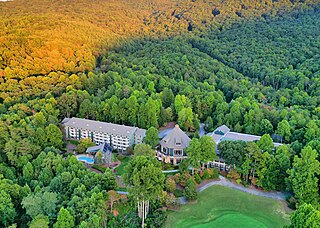
Brasstown Valley Resort & Spa is a 134 room resort on 503-acre (2.04 km2) just north of Young Harris, Georgia, surrounded by the Blue Ridge Mountains at 2,150-foot (660 m) elevation.
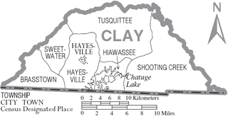
Sweetwater Township is one of the six townships of Clay County, North Carolina, United States, located in the northwestern part of the county. The other five are Brasstown, Hayesville, Shooting Creek, Hiawassee, and Tusquittee.
Blue Creek is a stream in White County, Georgia. It is a tributary of the Chattahoochee River. The creek is approximately 8.64 miles (13.90 km) long.
Dolly Varden is an unincorporated community in Clark County, in the U.S. state of Ohio.
Beaverdale is an unincorporated community in Whitfield County, in the U.S. state of Georgia.
Ashenden State Forest, sometimes written as Ashendon State Forest, is a 165-acre (67-hectare) protected area in the town of Warner, New Hampshire. It was donated to the state by Katharine Brown. She subsequently donated an easement on an adjacent 83 acres (34 ha) including a historic farmhouse. Brown died in 2005. Ashenden State Forest is located south of Cunningham Pond, the Chandler Reservation, and the Harriman Chandler State Forest.

Brasstown is an extinct Cherokee village in Towns County, in the U.S. state of Georgia. The exact location of Brasstown is unknown to the GNIS. It was situated about 8 miles (13 km) southwest of present-day Hiawassee on the upper part of Brasstown Creek.
Spaniard Knob or Spaniards Knob are the names of two distinct mountains in the Towns County, Georgia.