Blue Boar Street

Last updated

The St Aldate's Street entrance to Blue Boar Street, with the Oxford Town Hall and the entrance to the Museum of Oxford on the left. The St Aldates entrance to Blue Boar Lane.jpg
The St Aldate's Street entrance to Blue Boar Street, with the Oxford Town Hall and the entrance to the Museum of Oxford on the left.
The Bear public house, on the corner of Blue Boar Street and Alfred Street. The Bear Oxford.jpg
The Bear public house, on the corner of Blue Boar Street and Alfred Street.

Blue Boar Street is a narrow historic street running between St Aldate's to the west and the southern end of Alfred Street to the east, in central Oxford, England. [1] It is located just north of Christ Church.

At the western end is the Museum of Oxford and the Town Hall [2] to the north.

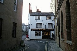
The Bear is a historic public house located on the north side of Blue Boar Street on the corner with Alfred Street. A unique feature is a large collection of short lengths of tie displayed on its walls and ceiling.

To the south is Christ Church, one of the largest Oxford colleges. Behind an old wall on Blue Boar Street are the modern 1960s buildings of the Blue Boar Quadrangle in the college, named after Blue Boar Street. [3] In 2006, this was Grade II* listed.

The street was formerly known as Tresham('s) Lane. [1] Blewebore Inn, once owned by King Henry III, was located here, hence the current name. The Blue Boar Inn was demolished in 1893 for the building of the Oxford Public Library, later the Museum of Oxford.

Related Research Articles

Llantwit Major Human settlement in Wales

Llantwit Major is a town and community in Wales on the Bristol Channel coast. It is one of four towns in the Vale of Glamorgan, with the third largest population after Barry and Penarth, and ahead of Cowbridge. It is 4+12 miles (7.2 km) from Cowbridge, 9 miles (14 km) from Bridgend, 10 miles (16 km) from Barry, and 15 miles (24 km) from Cardiff. It had a population of 9,486 in 2011.

Peckwater Quadrangle Grade I listed building in Oxford, United Kingdom

The Peckwater Quadrangle is one of the quadrangles of Christ Church, Oxford, England. It is a Grade I listed building.

Tom Quad One of the quadrangles of Christ Church, Oxford, England

The Great Quadrangle, more popularly known as Tom Quad, is one of the quadrangles of Christ Church, Oxford, England. It is the largest college quad in Oxford, measuring 264 by 261 feet. Although it was begun by Cardinal Wolsey in 1525–1529, he was unable to complete it before his fall from power.

The Meadow Building


The Meadow Building is part of Christ Church, Oxford, England, one of the Oxford colleges, looking out south onto Christ Church Meadow on Broad Walk and then along the straight tree-lined Poplar Walk to the River Thames.

Turl Street Street in central Oxford, England

Turl Street is a historic street in central Oxford, England.

Blue Boar Quadrangle Historic site in Oxford, Great Britain

The Blue Boar Quadrangle is a mid-century quadrangle within Christ Church, University of Oxford. Designed by Hidalgo Moya and Philip Powell, and built between 1965 and 1968, the quadrangle has been described by Lord McIntosh of Haringey as "one of the best buildings of its kind during the expansion of higher education". Since 17 October 2006, the quadrangle has held the classification of being Grade II* listed, due to the unique nature of its 1960s architecture.

Broad Street, Oxford Street in central Oxford, England

Broad Street is a wide street in central Oxford, England, just north of the former city wall. The street is known for its bookshops, including the original Blackwell's bookshop at number 50, located here due to the University of Oxford. Among residents, the street is traditionally known as The Broad.

Holywell Street, Oxford Street in central Oxford, England

Holywell Street is a street in central Oxford, England. It runs east-west with Broad Street to the west and Longwall Street to the east. About halfway along, Mansfield Road adjoins to the north.

St Aldates, Oxford

St Aldate's is a street in central Oxford, England, named after Saint Aldate, but formerly known as Fish Street.

<span class="mw-page-title-main">Merton Street</span> Street in central Oxford, England

Merton Street is a historic and picturesque cobbled street in central Oxford, England. It joins the High Street at its northeastern end, between the Ruskin School of Drawing and Fine Art and the Eastgate Hotel at the historic east gate of the city. It then runs east–west, parallel and to the south of the High Street for most of its length.

The Bear, Oxford Building in Oxford, United Kingdom

The Bear is a pub in Oxford, England, that was founded in 1774 as The Jolly Trooper. It stands on the corner of Alfred Street and Blue Boar Street, opposite Bear Lane in the centre of Oxford, just north of Christ Church, on the site of St Edward's churchyard. It was converted from the early 17th century residence of the stableman (ostler) for the coaching inn, The Bear Inn, which was on the High Street, Oxford. When The Bear Inn was converted into private housing in 1801, The Jolly Trooper changed its name to The Bear. There is a claim that by adopting its name, the current (1774) Bear Inn has acquired the history of the pub on the High Street, and so is one of the oldest pubs in Oxford. In 1952 the then landlord, Alan Course, started a collection of tie ends; a selection of the over 4,500 ties are on display around the pub. The tie collection was used as part of the plot of Colin Dexter's novel Death Is Now My Neighbour, in which Inspector Morse consults the landlord in order to identify a club tie. The building was Class II listed in January 1954.

<span class="mw-page-title-main">Alfred Street</span> Street in central Oxford, England

Alfred Street is a street running between the High Street to the north and the junction with Blue Boar Street and Bear Lane at the southern end, in central Oxford, England. To the south is Christ Church, one of Oxford University's historic colleges.

<span class="mw-page-title-main">Bear Lane</span> Street in central Oxford, England

Bear Lane is a short historic street in central Oxford, England. The lane is located just north of Christ Church. It runs between the junction of Blue Boar Street and Alfred Street to the west, and King Edward Street and the north of Oriel Square to the east.

<span class="mw-page-title-main">Market Street, Oxford</span> Street in central Oxford, England

Market Street is a street in central Oxford, England, running east to west.

Longworth Human settlement in England

Longworth is a village and civil parish in the Vale of White Horse, England. The 1974 boundary changes transferred it from Berkshire to Oxfordshire. It lies about 7 miles (11 km) west of Abingdon-on-Thames and 9 miles (14 km) south-west of Oxford. The 2011 Census recorded a population of 566, which was estimated at 570 in 2019. The parish is bounded by the River Thames to the north, the A420 road to the south, and field boundaries to the east and west. The land slopes from the A420 to the river, except at Harrowdown Hill near the north-east corner of the parish, which has a summit of 325 feet (99 m).

St Thomas the Martyrs Church, Oxford Church in United Kingdom

St Thomas the Martyr's is a Church of England parish church of the Anglo-Catholic tradition, in Oxford, England, near Oxford railway station in Osney. It is located between Becket Street to the west and Hollybush Row to the east, with St Thomas Street opposite.

Vine Hall was an academic hall of the University of Oxford, located on Alfred Street in the 16th century. It became a part of the Peckwater Quadrangle of Christ Church, Oxford. The building gave its name to the previous name for Alfred Street, particularly the southwards continuation of it; Vine Hall Lane. Some have said that the current name Alfred Street is of unknown aetiology and pointless, and the street should be renamed Vine Hall Lane. It was previously known as St Edward's Lane, but the name Vine Hall Lane was in use by 1576.

The Boar's Head Theatre was an inn-yard theatre in the Whitechapel area of London from 1598 to around 1616.

<span class="mw-page-title-main">Brewer Street, Oxford</span> Street in central Oxford, London

Brewer Street is a historic narrow street in central Oxford, England, south of Carfax. The street runs east-west, connecting with St Aldate's to the east and St Ebbe's Street to the west.

<span class="mw-page-title-main">Bull and Mouth Inn</span>

The Bull and Mouth Inn was a coaching inn in the City of London that dated from before the Great Fire of London in 1666. It was located between Bull and Mouth Street in the north and Angel Street in the south. It was once an important arrival and departure point for coaches from all over Britain, but particularly for the north of England and Scotland. It became the Queen's Hotel in 1830 but was demolished in 1887 or 1888 when new post office buildings were built in St Martin's Le Grand.

References

  1. 1 2 Hibbert, Christopher, ed. (1988). "Blue Boar Street". The Encyclopaedia of Oxford . Macmillan. p. 46. ISBN   0-333-39917-X.
  2. Where To Find Our Offices: Key Council Building Addresses Archived 3 September 2009 at the Wayback Machine , Oxford City Council.
  3. Blue Boar Street, Flickr.

Coordinates: 51°45′05″N1°15′23″W / 51.7513°N 1.2563°W / 51.7513; -1.2563