The Blue Boar Quadrangle is a mid-century quadrangle within Christ Church, University of Oxford. Designed by Hidalgo Moya and Philip Powell, and built between 1965 and 1968, the quadrangle has been described by Lord McIntosh of Haringey as "one of the best buildings of its kind during the expansion of higher education". Since 17 October 2006, the quadrangle has held the classification of being Grade II* listed, due to the unique nature of its 1960s architecture.
The Oriel Square tennis court was a real tennis court that was located in Oriel Square, central Oxford, England. The Liber Albus mentions the Oriel court being in Vinehall Lane in 1577.
St Aldate's is a street in central Oxford, England, named after Saint Aldate, but formerly known as Fish Street.

Merton Street is a historic and picturesque cobbled street in central Oxford, England. It joins the High Street at its northeastern end, between the Ruskin School of Drawing and Fine Art and the Eastgate Hotel at the historic east gate of the city. It then runs east–west, parallel and to the south of the High Street for most of its length.
Oriel Square, formerly known as Canterbury Square, is a square in central Oxford, England, located south of the High Street. The name was changed after the Second World War at the request of Oriel College which maintained that the square had originally been known as Oriel Square.

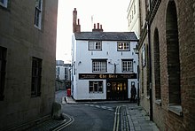
The Bear is a pub in Oxford, England, that was founded in 1774 as The Jolly Trooper. It stands on the corner of Alfred Street and Blue Boar Street, opposite Bear Lane in the centre of Oxford, just north of Christ Church, on the site of St Edward's churchyard. It was converted from the early 17th century residence of the stableman (ostler) for the coaching inn, The Bear Inn, which was on the High Street, Oxford. When The Bear Inn was converted into private housing in 1801, The Jolly Trooper changed its name to The Bear. There is a claim that by adopting its name, the current (1774) Bear Inn has acquired the history of the pub on the High Street, and so is one of the oldest pubs in Oxford. In 1952 the then landlord, Alan Course, started a collection of tie ends; a selection of the over 4,500 ties are on display around the pub. The tie collection was used as part of the plot of Colin Dexter's novel Death Is Now My Neighbour, in which Inspector Morse consults the landlord in order to identify a club tie. The building was Class II listed in January 1954.

Blue Boar Street is a narrow historic street running between St Aldate's to the west and the southern end of Alfred Street to the east, in central Oxford, England. It is located just north of Christ Church.

Bear Lane is a short historic street in central Oxford, England. The lane is located just north of Christ Church. It runs between the junction of Blue Boar Street and Alfred Street to the west, and King Edward Street and the north of Oriel Square to the east.
Oriel Street is a narrow but historic street running between the High Street to the north and Oriel Square to the south in central Oxford, England. The street is now blocked off to traffic by bollards at the High Street end.
Queen's Lane is a historic street in central Oxford, England, named after Queen's College, to the south and west. St Edmund Hall, a constituent college of the University of Oxford, is located on the southern end of this street.

Catte Street is a historic street in central Oxford, England.

New Inn Hall Street is a street in central Oxford, England, and is one of Oxford's oldest streets. It is a shopping street running north–south parallel and to the west of Cornmarket Street, with George Street to the north and Bonn Square at the west end of Queen Street to the south. St Michael's Street leads off the street to the east near the northern end. Shoe Lane to the east leads to the Clarendon Centre, a modern shopping centre.
Vine Hall was an academic hall of the University of Oxford, located on Alfred Street in the 16th century. It became a part of the Peckwater Quadrangle of Christ Church, Oxford. The building gave its name to the previous name for Alfred Street, particularly the southwards continuation of it; Vine Hall Lane. Some have said that the current name Alfred Street is of unknown aetiology and pointless, and the street should be renamed Vine Hall Lane. It was previously known as St Edward's Lane, but the name Vine Hall Lane was in use by 1576.

St Nicholas Shambles was a medieval church in the City of London, which stood on the corner of Butcher Hall Lane and Newgate Street. It took its name from the Shambles, the butchers area in the west of Newgate Street. The church is first mentioned as St. Nicholas de Westrnacekaria. In 1253 Walter de Cantilupe, Bishop of Worcester granted indulgences to its parishioners.
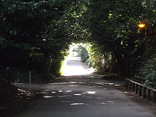
Pullens Lane is in Headington, east Oxford, England. It is located at the top of Headington Hill, leading north off Headington Road to Jack Straw's Lane and Harberton Mead. The cul-de-sac Pullens Field leads off west from Pullens Lane.

Marylebone is a district in the West End of London, in the City of Westminster. Oxford Street, Europe's busiest shopping street, forms its southern boundary.

Lombard Street is a street notable for its connections with the City of London's merchant, banking and insurance industries, stretching back to medieval times.

Brewer Street is a historic narrow street in central Oxford, England, south of Carfax. The street runs east-west, connecting with St Aldate's to the east and St Ebbe's Street to the west.

Grove Walk is a short historic leafy walkway running north–south in central Oxford, England, situated on land between Merton College to the east and Corpus Christi College to the west. It provides one of the entrances to Christ Church Meadow from the north.
This is a list of the etymology of street names in the London district of Southwark. The area has no formally defined boundaries – those utilised here are: the river Thames to the north, Tower Bridge Road to the east, Bricklayers Arms/New Kent Road/Elephant and Castle to the south, and London Road/St George's Circus/Blackfriars Road to the west.