Related Research Articles

John Baskerville was an English businessman, in areas including japanning and papier-mâché, but he is best remembered as a printer and type designer.

~~~~

Christ Church is a constituent college of the University of Oxford in England. Christ Church is a joint foundation of the college and the cathedral of the Oxford diocese, which serves as the college chapel and whose dean is ex officio the college head.

Corpus Christi College, is one of the constituent colleges of the University of Oxford in the United Kingdom. Founded in 1517, it is the 12th oldest college in Oxford.

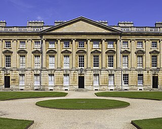
Oriel College is a constituent college of the University of Oxford in Oxford, England. Located in Oriel Square, the college has the distinction of being the oldest royal foundation in Oxford. In recognition of this royal connection, the college has also been historically known as King's College and King's Hall. The reigning monarch of the United Kingdom is the official visitor of the college.
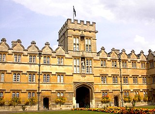
University College is a constituent college of the University of Oxford in England. It has a claim to being the oldest college of the university, having been founded in 1249 by William of Durham.

Christ Church Meadow is a well-known flood-meadow, and popular walking and picnic spot in Oxford, England.
The Peckwater Quadrangle is one of the quadrangles of Christ Church, Oxford, England. It is a Grade I listed building.

The Blue Boar Quadrangle is a quadrangle at the University of Oxford's Christ Church. It was designed by Hidalgo Moya and Philip Powell, and built between 1965 and 1968. The quadrangle has been described as "One of the best buildings of its kind during the expansion of higher education" by Lord McIntosh of Haringey, Minister for Culture, Media and Sport. The quadrangle has held the classification of Grade II* listed building since 17 October 2006, a status shared by only 20,000 other structures in the country due to the unique nature of its 1960s architecture. Blue Boar underwent a substantial renovation from 2007-8, resulting in the conversion of all rooms to modern en-suites.

Merton Street is a historic and picturesque cobbled street in central Oxford, England. It joins the High Street at its northeastern end, between the Ruskin School of Drawing and Fine Art and the Eastgate Hotel at the historic east gate of the city. It then runs east–west, parallel and to the south of the High Street for most of its length.
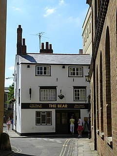
The Bear Inn is one of the oldest pubs in Oxford, England, dating back to 1242. Its circa-17th century incarnation stands on the corner of Alfred Street and Blue Boar Street, opposite Bear Lane in the centre of Oxford, just north of Christ Church.

Alfred Street is a street running between the High Street to the north and the junction with Blue Boar Street and Bear Lane at the southern end, in central Oxford, England. To the south is Christ Church, one of Oxford University's historic colleges.

Blue Boar Street is a narrow historic street running between St Aldate's to the west and the southern end of Alfred Street to the east, in central Oxford, England. It is located just north of Christ Church.

St. Martin's Le Grand is a former liberty within the City of London, and is the name of a street north of Newgate Street and Cheapside and south of Aldersgate Street. It forms the southernmost section of the A1 road.
Charles Patrick Wormald was a British historian born in Neston, Cheshire, son of historian Brian Wormald.

Marylebone is an area in the West End of London, in the City of Westminster. Oxford Street, Europe's busiest shopping street, forms its southern boundary.

Brewer Street is a historic narrow street in central Oxford, England, south of Carfax. The street runs east-west, connecting with St Aldate's to the east and St Ebbe's Street to the west.

The Canterbury Quadrangle is one of the quadrangles of Christ Church, Oxford, England. It stands on the site of the former Canterbury College.

The following is a timeline of the history of the city, University and colleges of Oxford, England.

Swallow Street is a small street in the West End of London, running north from Piccadilly. It is about 341 feet (104 m) long.
References
- ↑ The Encyclopaedia of Oxford
- ↑ British history online
- ↑ Ingram, James (1847). Memorials of the Colleges and Halls in the University of Oxford (2 ed.). John Henry Parker. pp. 57 . Retrieved 1 February 2009.
- ↑ Wade, W. M.; Baxter, William; Pearson, R.; Law; Whittaker (1818). Walks in Oxford (2 ed.). Printed by W. Baxter for R. Pearson. p. 236. Retrieved 1 February 2009.
- ↑ Chalmers, Alexander; Storer, James; Greig, John (1810). A History of the Colleges, Halls, and Public Buildings, Attached to the University of Oxford: Including the Lives of the Founders. Printed by Collingwood and co. pp. 330 . Retrieved 1 February 2009.
- ↑ Simon, Joan (1979). Education and Society in Tudor England. Cambridge University Press. p. 86. ISBN 0-521-29679-X . Retrieved 1 February 2009.