
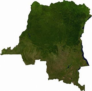
The Democratic Republic of the Congo (DRC) is the largest country of sub-Saharan Africa, occupying some 2,344,858 square kilometres (905,355 sq mi). Most of the country lies within the vast hollow of the Congo River basin. The vast, low-lying central area is a plateau-shaped basin sloping toward the west, covered by tropical rainforest and criss-crossed by rivers. The forest center is surrounded by mountainous terraces in the west, plateaus merging into savannas in the south and southwest. Dense grasslands extend beyond the Congo River in the north. High mountains of the Ruwenzori Range are found on the eastern borders with Rwanda and Uganda.

Rwanda is located in East Africa, to the east of the Democratic Republic of the Congo, at the co-ordinates 2°00′S30°0′E.

Uganda is located in Eastern Africa, West of Kenya, South of South Sudan, East of the Democratic Republic of the Congo, and North of Rwanda and Tanzania. While much of its border is on lakeshores, Uganda is landlocked with no access to the sea port but it is a fertile and well-watered country that consists of many lakes and rivers including the largest, Lake Victoria. The country sits in the heart of the Great Lakes region, with Lake Edward, Lake George and Lake Albert on its Western border, Lake Kyoga in the Eastern part of Uganda. It is found in Central Saharan Africa and receives reliable rainfall throughout the year. Rivers are River Nile the longest river in Africa, River Kagera, River Katonga, River Semiliki and River Sezibwa.

The White Nile is a river in Africa, the minor of the two main tributaries of the Nile, the larger being the Blue Nile. The name "White" comes from the clay sediment carried in the water that changes the water to a pale color.

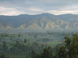
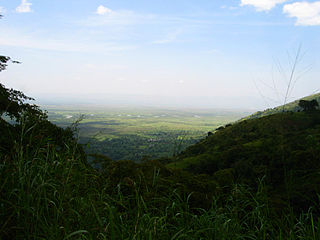
The Ruwenzori, also spelled Rwenzori and Rwenjura, or Rwenzururu are a range of mountains in eastern equatorial Africa, located on the border between Uganda and the Democratic Republic of the Congo. The highest peak of the Ruwenzori reaches 5,109 metres (16,762 ft), and the range's upper regions are permanently snow-capped and glaciated. Rivers fed by mountain streams form one of the sources of the Nile. Because of this, European explorers linked the Ruwenzori with the legendary Mountains of the Moon, claimed by the Greek scholar Ptolemy as the source of the Nile. Virunga National Park in eastern DR Congo and Rwenzori Mountains National Park in southwestern Uganda are located within the range.

Lake Albert, originally known as Lake Mwitanzige by the Banyoro, Nam Ovoyo Bonyo by the Alur, and temporarily as Lake Mobutu Sese Seko, is a lake located in Uganda and the Democratic Republic of the Congo. It is Africa's seventh-largest lake, as well as the second biggest of Uganda's Great Lakes.
North Kivu is a province bordering Lake Kivu in the eastern Democratic Republic of the Congo. Its capital is Goma. The 2020 population was estimated to be 8,147,400.
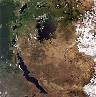
The African Great Lakes are a series of lakes constituting the part of the Rift Valley lakes in and around the East African Rift. The series includes Lake Victoria, the second-largest freshwater lake in the world by area; Lake Tanganyika, the world's second-largest freshwater lake by volume and depth; Lake Malawi, the world's eighth-largest freshwater lake by area; and Lake Turkana, the world's largest permanent desert lake and the world's largest alkaline lake. Collectively, they contain 31,000 km3 (7,400 cu mi) of water, which is more than either Lake Baikal or the North American Great Lakes. This total constitutes about 25% of the planet's unfrozen surface fresh water. The large rift lakes of Africa are the ancient home of great biodiversity, and 10% of the world's fish species live in this region.

Virunga National Park is a national park in the Albertine Rift Valley in the eastern part of the Democratic Republic of the Congo. It was created in 1925. In elevation, it ranges from 680 m (2,230 ft) in the Semliki River valley to 5,109 m (16,762 ft) in the Rwenzori Mountains. From north to south it extends approximately 300 km (190 mi), largely along the international borders with Uganda and Rwanda in the east. It covers an area of 8,090 km2 (3,120 sq mi).

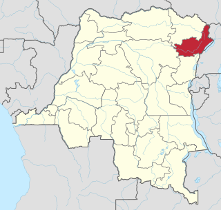
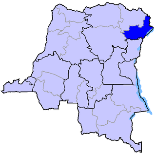
Ituri Province is one of the 21 provinces of the Democratic Republic of the Congo created in the 2015 repartitioning. Ituri, Bas-Uele, Haut-Uele, and Tshopo provinces are the result of the subdividing of the former Orientale province. Ituri was formed from the Ituri district whose town of Bunia was elevated to capital city of the new province.

The Ituri conflict is an ongoing low intensity asymmetrical conflict between the agriculturalist Lendu and pastoralist Hema ethnic groups in the Ituri region of the north-eastern Democratic Republic of the Congo (DRC). While the two groups had fought since as early as 1972, the name "Ituri conflict" refers to the period of intense violence between 1999 and 2003. Armed conflict continues to the present day.

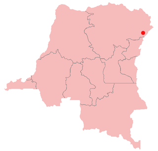
Bunia is the capital city of Ituri Province in the Democratic Republic of the Congo (DRC). It was part of the Orientale Province until that province's dissolution.
Operation Artemis, formally European Union Force Democratic Republic of the Congo (EUFOR), was a short-term European Union-led UN-authorised military mission to the Democratic Republic of the Congo in 2003, during the Ituri conflict. ARTEMIS is considered the first military operation led by the EU, the first autonomous EU operation, the first rapid response mission of the EU, first operation outside Europe, first operation applying the principle of the framework nation and first example of "relay operation", conducted in cooperation between the EU and the United Nations. The deployment of EUFOR troops quickly decreased the conflict's intensity. It marked the first autonomous EU military mission outside Europe and an important milestone in development of the European Security and Defence Policy.
Semliki River is a major river, 140 kilometres (87 mi) long, in the Democratic Republic of the Congo (DRC) and Uganda in Central and East Africa. It flows north from Lake Edward in Beni Territory, Nord-Kivu, D.R.C avoiding the Rwenzori Mountains on its Right (East), emptying into Lake Albert in the Albertine Rift, Irumu Territory, Ituri Province, D.R.C overlooking the Blue Mountains to its left in the west. Its mouth is near the Village of Katolingo in Kanara subcounty, Ntoroko district, Uganda. Along its lower reaches, it meanders extensively forming part of the international border between the DRC and the western Ugandan districts of Bundibugyo and Ntoroko, near the Semuliki National Park.
Articles related to the Democratic Republic of the Congo include:
Congolese history in the 2000s has primarily revolved around the Second Congo War (1998–2003) and the empowerment of a transitional government.
The Ituri Interim Administration is an interim body that administers the Ituri region of the Democratic Republic of Congo (DRC). It was established in 2003 by the Ituri Pacification Commission and supported by the UN mission in the DRC.
United Nations Security Council Resolution 1484, adopted unanimously on 30 May 2003, after recalling previous resolutions on the situation in the Democratic Republic of the Congo, the Council authorised Operation Artemis in Bunia, the capital of Ituri Province, amid the deteriorating security situation in the area.

United Nations Security Council resolution 1596, adopted unanimously on 18 April 2005, after recalling all previous resolutions on the situation in the Democratic Republic of the Congo, including resolutions 1493 (2003), 1533 (2004), 1552 (2004), 1565 (2004) and 1592 (2005), the council expanded the arms embargo to include all recipients of weapons in the country, and imposed a travel ban and asset freeze on those violating the embargo.

The geography of South Sudan describes the physical features of South Sudan, a country in East Africa. South Sudan is a landlocked country and borders – clockwise – Sudan from the north, Ethiopia from the east, Kenya, Uganda and the Democratic Republic of the Congo from the south and the Central African Republic from the west.