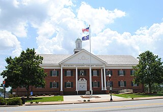
Blue Ridge and Atlantic Railroad

Last updated

The Blue Ridge and Atlantic Railroad of the United States purchased the Cornelia-Tallulah Falls section of the North Eastern Rail Road in an attempt to connect Savannah, Georgia to Knoxville, Tennessee. Chartered in 1887, it went bankrupt in about 1892 and in 1898 its properties became part of the newly formed Tallulah Falls Railway. [1]

Contents

Early history

The railway had an earlier history under the name Blue Ridge Railway which was organized before the American Civil War and had some rather ambitious projects which never were fully developed. One of these was to build a road from Walhalla, South Carolina to Chattanooga, Tennessee which would have shortened the route to Chattanooga by cutting off Atlanta and thus creating an economic boon to the border areas of North Carolina, South Carolina and Georgia with this connection to the West. The Blue Ridge Railway had begun business around the late 1840s and connected Charleston with the Upstate from the original tracks that ran from Charleston to Hamburg (North Augusta, SC today). It ran from Columbia to Greenville via what is now Newberry, SC. thence to Abbeville and Belton and from there to Greenville, SC. Mary Chesnut in her diaries mentions this road. It was for a long while the only upstate railroad until what is now Norfolk Southern built a road around 1890.

Legend

Because of its early operational period to the upstate, the Blue Ridge railroad has been the subject of legends and misinformation for over 100 years regarding the Fall of Richmond. Folks in Abbeville, S.C. will swear that Confederate President Jefferson Davis brought a steam locomotive train load of Confederate gold from Richmond's Banks to Abbeville and buried it near the present railroad tracks or near the Savannah River (now under water). People in Chester, SC and in Washington, Ga will tell the same tale. This is simply not true. Davis left Richmond by train for Danville, Va and from there he went to Charlotte, N.C. where he was coolly received; thence to Chester, South Carolina where tracks ended. The party continued to Abbeville via Conestoga wagons (wagon train) to Hodges, SC and thence to Abbeville.

While they could have taken a train from Newberry, it was just too dangerous and for that reason to avoid capture the wagon train (as opposed to steam train) continued south until Davis was captured just below Washington, Georgia. What gold there was returned to Richmond Banks by 1910, although some has never been accounted for. The unrecovered gold probably ended up in a Bank in Charleston, SC with a mysterious Rhett Butler figure who was treasurer of the Confederacy and who became inexplicably rich after the Civil War running a bank in Charleston.

Construction

Work in earnest began before the Civil War, much of it done with slave labor as well as that of paid Scots-Irish and German Immigrants (who founded the town of Walhalla). The road was finished as far as the Stumphouse Mountain area (in Oconee County) where a tunnel through the mountain was begun before the war brought a halt to the project. Supposedly, the tunnel was being dug and blasted from both sides of the mountain but this writer[ who? ] has not found the roadbed from the other side, although there are shafts cut from above into the tunnel which one can fall into if one is not familiar with the top of the mountain. The other side of the tunnel is now under Crystal Lake. Some of the road bed can be found near this lake which is a few miles up the road from Stumphouse Mountain. Locals state that prior to flooding the tunnel still contained tools and iron from the original construction.

Closure

The railway ceased to exist around 1890 as the Blue Ridge Railway and went into foreclosure. Some of the tracks were taken over by Richmond and Danville Railroad which continued the tracks to Atlanta and in 2006 is still operational after more than 100 years of service. The tracks from Columbia still exist and are used by successive companies. However, the tracks that ran from Abbeville to Augusta, SC(or Hamburg) sit abandoned and rotting and are basically unusable, creating at the same time modern South Carolina ghost towns, or towns on the verge of being so, especially between Abbeville and McCormick, SC. The Belton route tracks are in 2006 still functional, at least in the Greenville area.

Cheese-making

The uncompleted Stumphouse Mountain Tunnel remains and was used for many years as an ideal place to make and store blue cheese by Clemson University (formerly Clemson College). This cheese is and was genuine Roquefort except for the place of origin. During World War I, a Clemson professor had obtained the native strain of spores of Penicillium roquefortii in Roquefort, France and thus began the Clemson Cheese Industry. The University ceased using the tunnel around 1960 and the cheese making was moved to campus and moved again around 1980 to a more modern facility near Anderson, SC.

State Park

Today the tunnel is a State Park near spectacular Isaqueena Falls. Isaqueena Falls is named after a fictional Indian Princess. The Cherokee were very prevalent all around Upstate South Carolina. Cateechee was the supposed Indian princess, she was called Isaqueena in the Choctaw language. Local legend states that Cateechee overheard the Cherokee Indian chief planning an attack on Cambridge Fort (which was the Star Fort at Ninety-Six, South Carolina). When she heard this she left the Cherokee town of Keowee to warn her white lover Allen Francis who was at the fort ninety-six miles away. Along her journey, she named the streams and creeks that she crossed. The town of Six Mile, Twelve Mile Creek, Eighteen Mile Creek, Three and Twenty Creek, Six and Twenty Creek, and the town of Ninety Six are the current names on maps today. These towns and creeks are located in Pickens, Anderson, Abbeville, and Greenwood counties in South Carolina. The legend probably is not true considering the same story in various other parts of the Continental US and in Guam ("Lover's leap") there. There were significant rockslides in the tunnel early in the 21st Century, so access into the tunnel is blocked off after several hundred yards.

  1. "The Tallulah Falls Railroad: 58-Mile Short Line, Little Teapots and Catalyst for Economic Development". Rabun County Historical Society. Retrieved 2023-12-01.

Related Research Articles

<span class="mw-page-title-main">Blacksburg, South Carolina</span> Town in South Carolina, United States

Blacksburg is a small town in Cherokee County, South Carolina, United States. The population was 1,848 at the 2010 census. The communities of Cherokee Falls, Kings Creek, Cashion Crossroads, Buffalo, and Mount Paran are located near the town.

<span class="mw-page-title-main">Blue Ridge Parkway</span> Scenic parkway in the United States

The Blue Ridge Parkway is a National Parkway and All-American Road in the United States, noted for its scenic beauty. The parkway, which is America's longest linear park, runs for 469 miles (755 km) through 29 Virginia and North Carolina counties, linking Shenandoah National Park to Great Smoky Mountains National Park. It runs mostly along the spine of the Blue Ridge, a major mountain chain that is part of the Appalachian Mountains. Its southern terminus is at U.S. Route 441 (US 441) on the boundary between Great Smoky Mountains National Park and the Qualla Boundary of the Eastern Band of Cherokee Indians in North Carolina, from which it travels north to Shenandoah National Park in Virginia. The roadway continues through Shenandoah as Skyline Drive, a similar scenic road which is managed by a different National Park Service unit. Both Skyline Drive and the Virginia portion of the Blue Ridge Parkway are part of Virginia State Route 48 (SR 48), though this designation is not signed.

<span class="mw-page-title-main">Tallulah River</span> River in Georgia, United States

The Tallulah River is a 47.7-mile-long (76.8 km) river in Georgia and North Carolina. It begins in Clay County, North Carolina, near Standing Indian Mountain in the Southern Nantahala Wilderness and flows south into Georgia, crossing the state line into Towns County. The river travels through Rabun County and ends in Habersham County. It cuts through the Tallulah Dome rock formation to form the Tallulah Gorge and its several waterfalls. The Tallulah River intersects with the Chattooga River to form the Tugaloo River at Lake Tugalo in Habersham County. It joins South Carolina's Seneca River at Lake Hartwell to form the Savannah River, which flows southeastward into the Atlantic Ocean.

<span class="mw-page-title-main">Saluda Grade</span> Steepest standard-gauge mainline railway grade in the United States

Saluda Grade was the steepest standard-gauge mainline railway grade in the United States. Owned by the Norfolk Southern Railway as part of its W Line, Saluda Grade in Polk County, North Carolina, gained 606 feet (185 m) in elevation in less than three miles (4.8 km) between Melrose and Saluda. Average grade was 4.24 percent for 2.6 miles (4.2 km) and maximum was 4.9% for about 300 feet (91 m). In December 2001, Norfolk Southern took the line containing the grade out of service for economic reasons.

<span class="mw-page-title-main">Chesapeake and Ohio Railway</span> Defunct American Class I railway

The Chesapeake and Ohio Railway was a Class I railroad formed in 1869 in Virginia from several smaller Virginia railroads begun in the 19th century. Led by industrialist Collis P. Huntington, it reached from Virginia's capital city of Richmond to the Ohio River by 1873, where the railroad town of Huntington, West Virginia, was named for him.

<span class="mw-page-title-main">Virginia Central Railroad</span> Railroad in Virginia

The Virginia Central Railroad was an early railroad in the U.S. state of Virginia that operated between 1850 and 1868 from Richmond westward for 206 miles (332 km) to Covington. Chartered in 1836 as the Louisa Railroad by the Virginia General Assembly, the railroad began near the Richmond, Fredericksburg and Potomac Railroad's line and expanded westward to Orange County, reaching Gordonsville by 1840. In 1849, the Blue Ridge Railroad was chartered to construct a line over the Blue Ridge Mountains for the Louisa Railroad which reached the base of the Blue Ridge in 1852. After a decision from the U.S. Supreme Court, the Louisa Railroad was allowed to expand eastward from a point near Doswell to Richmond.

The Clinchfield Railroad was an operating and holding company for the Carolina, Clinchfield and Ohio Railway. The line ran from the coalfields of Virginia and Elkhorn City, Kentucky, to the textile mills of South Carolina. The 35-mile segment from Dante, Virginia, to Elkhorn City, opening up the coal lands north of Sandy Ridge Mountains and forming a connection with the Chesapeake and Ohio Railway at Elkhorn City, was completed in 1915.

<span class="mw-page-title-main">Tallulah Falls Railway</span> Defunct American railroad

The Tallulah Falls Railway, also known as the Tallulah Falls Railroad, "The TF" and "TF & Huckleberry," was a railroad based in Tallulah Falls, Georgia, U.S. which ran from Cornelia, Georgia to Franklin, North Carolina. It was commissioned by the Georgia General Assembly on January 27, 1854, and conducted its final run on March 25, 1961.

Buckingham Branch Railroad is a Class III short-line railroad operating over 275 miles (443 km) of historic and strategic trackage in Central Virginia. Sharing overhead traffic with CSX and Amtrak, the company's headquarters are in Dillwyn, Virginia in the former Chesapeake and Ohio Railroad (C&O) station, itself a historic landmark in the community. The railroad was featured in the January 2012 issue of Trains Magazine. It is referenced in the How It’s Made episode “Railway Bridge Ties”, showing it crossing a curved bridge.

The Augusta and Knoxville Railroad (A&K) was a railroad company that operated on 66 miles (106 km) of track between Augusta, Georgia, and Greenwood, South Carolina, from 1882 to 1886. It was merged with three other companies to form the Port Royal and Western Carolina Railway, which was reorganized in 1896 as the Charleston and Western Carolina Railway.

The Blue Ridge Railway was a 19th-century railroad in the U.S. state of South Carolina. It was originally chartered in 1852 as the Blue Ridge Railroad of South Carolina. Original plans were for a 195-mile line from Anderson, South Carolina, to Knoxville, Tennessee going through the mountains with as many as 13 tunnels including the incomplete Stumphouse Mountain Tunnel.

<span class="mw-page-title-main">Keowee</span> Historic Cherokee town

Keowee was a Cherokee town in the far northwest corner of present-day South Carolina. It was the principal town of what were called the seven Lower Towns, located along the Keowee River. Keowee was situated on the Lower Cherokee Traders' Path, part of the Upper Road through the Piedmont. In 1752 the Cherokee established New Keowee Town nearby, off the traders' path but in a more defensible location.

<span class="mw-page-title-main">Stumphouse Mountain Tunnel</span> United States historic place

Stumphouse Mountain Tunnel in Oconee County, South Carolina is an incomplete railroad tunnel for the Blue Ridge Railroad of South Carolina in Sumter National Forest. The tunnel, along with nearby Issaqueena Falls, are now a Walhalla city park.

<span class="mw-page-title-main">South Carolina Highway 11</span> State highway in South Carolina

South Carolina Highway 11 (SC 11), also known as the Cherokee Foothills Scenic Highway, is a 119.850-mile (192.880 km) state highway through the far northern part of the U.S. state of South Carolina, following the southernmost peaks of the Blue Ridge Mountains. The route is surrounded by peach orchards, quaint villages, and parks. It is an alternative to Interstate 85 (I-85) and has been featured by such publications as National Geographic, Rand McNally, and Southern Living.

<span class="mw-page-title-main">Southern Highroads Trail</span>

The Southern Highroads Trail is a 364-mile-long (586 km) loop of scenic and historic highways in the Southeastern United States. The driving trail traverses 14 counties, four states, and four national forests, providing sightseers and passersby an array of culinary, hotel, shopping, and recreational options along the way.

<span class="mw-page-title-main">Piedmont Atlantic megaregion</span> Neologism

The Piedmont Atlantic megaregion is a neologism created by the Regional Plan Association for an area of the Southeastern United States that includes the Atlanta, Birmingham, Charlotte, Memphis, Nashville, Research Triangle (Raleigh-Durham), and Greensboro-Winston-Salem-High Point metropolitan areas. The megaregion generally follows the Interstate 85/20 corridor. According to Georgia Tech, the Piedmont Atlantic represents over 12 percent of the total United States population and covers over 243,000 square miles (630,000 km2) of land.

The Carolina, Knoxville and Western Railway was a South Carolina railroad that existed in the latter half of the 19th century.

<span class="mw-page-title-main">South Carolina Highway 28</span> State highway in South Carolina

South Carolina Highway 28 (SC 28) is a 131.220-mile (211.178 km) primary state highway in the U.S. state of South Carolina. It consists of two segments of highway signed as east–west but physically traveling north–south from the Georgia state line near Mountain Rest to Beech Island. It is part of a continuous highway separated by a 17.5-mile (28.2 km) stretch through Augusta, Georgia.

<span class="mw-page-title-main">South Carolina Highway 130</span>

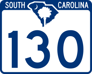
South Carolina Highway 130 (SC 130) is a 30.072-mile (48.396 km) state highway in Oconee County, South Carolina, connecting Clemson and eastern Oconee County with access to Lake Keowee, Lake Jocassee, and the Blue Ridge Mountains.

<span class="mw-page-title-main">South Carolina Highway 20</span> State highway in South Carolina

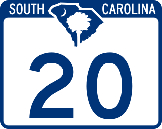
South Carolina Highway 20 (SC 20) is a primary state highway in the U.S. state of South Carolina. The highway connects the cities of Abbeville, Belton, Williamston and Greenville. The 53-mile-long (85 km) highway is signed as a west-east highway though it physically runs south-to-north.