Bo'ness Town Hall

Last updated

Bo'ness Town Hall
Bo'ness Town Hall (geograph 3903312).jpg
Bo'ness Town Hall
LocationStewart Avenue, Bo'ness
Coordinates 56°00′57″N3°36′30″W / 56.0157°N 3.6082°W / 56.0157; -3.6082 Coordinates: 56°00′57″N3°36′30″W / 56.0157°N 3.6082°W / 56.0157; -3.6082
Built1904
Architect George Washington Browne
Architectural style(s) Renaissance style
Listed Building – Category B
Official nameStewart Avenue, Town Hall and former Carnegie Library including boundary walls and gatepiers
Designated25 November 1980
Reference no.LB22397
Falkirk UK location map.svg
Red pog.svg
Shown in Falkirk

Bo'ness Town Hall is a municipal building in Stewart Avenue, Bo'ness, Scotland. The structure, which was the meeting place of Bo'ness Burgh Council, is a Category B listed building. [1]

Contents

History

The first town hall was a building with a clock tower in North Street which was completed in around 1780. [2] [3] It became structurally unstable as a result of mine workings, located just 15 meters below the surface, and partially collapsed in 1885. [4] [5] In the 1890s, in the context of continuing concerns about the structural integrity of the old town hall, the burgh commissioners decided to procure a new building. [6] The site they selected for the proposed new building and surrounding park was occupied by a mansion known as The Manse which was the residence of the minister at Bo'ness Old Kirk. [7] [8]

A design completion was held and a tender by George Washington Browne was accepted in October 1902. [6] The Scottish-American industrialist and philanthropist, Andrew Carnegie, offered to pay for the cost of a public library in the building and his contribution was supplemented by a donation from the Common Good Fund. [9]

The new building was designed in the Renaissance style, built in ashlar stone at a cost of £12,000 and was officially opened by the Edinburgh City Librarian, Hew Morrison, on 14 September 1904. [10] [11] The ceremony involved the burial of glass jar, which contained copies of The Scotsman, The Glasgow Herald, The Bo'ness Journal and The Linlithgow Gazette, as well as a list of councillors and a copy of the council minutes: a memorial stone was laid on top of the jar to identify where it had been laid. [12] The design involved an asymmetrical main frontage with nine bays facing onto Stewart Avenue; the central section of three bays, which was recessed, featured a doorway in the left hand bay and Diocletian windows on the first floor. The left hand section curved round to the rear of the building which faced the park and, at roof level, in addition to a balustrade, there were two small clock towers at the east end and a lantern at the west end. [1]

Queen Elizabeth II, accompanied by the Duke of Edinburgh, visited the town hall during a royal tour of Scotland in July 1955. [13] The town hall continued to serve as the headquarters of the burgh council for much of the 20th century but ceased to be local seat of government after the enlarged Falkirk District Council was formed in 1975. [14] The public library relocated to an early 18th century building, previously known as the West Pier Tavern, on Scotland Street in 1980, [15] [16] and the town hall subsequently functioned mainly as a local events venue, becoming an approved venue for wedding and civil partnership ceremonies. [17]

See also

Related Research Articles

<span class="mw-page-title-main">Hawick</span> A town in the Borders of Scotland

Hawick is a town in the Scottish Borders council area and historic county of Roxburghshire in the east Southern Uplands of Scotland. It is 10 miles (16.1 km) south-west of Jedburgh and 8.9 miles (14.3 km) south-south-east of Selkirk. It is one of the farthest towns from the sea in Scotland, in the heart of Teviotdale, and is the biggest town in the former county of Roxburghshire. The town is at the confluence of the Slitrig Water with the River Teviot.

<span class="mw-page-title-main">West Lothian</span> Council area of Scotland

West Lothian is one of the 32 council areas of Scotland, and was one of its historic counties. The county was called Linlithgowshire until 1925. The historic county was bounded geographically by the Avon to the west and the Almond to the east. The modern council area occupies a larger area than the historic county. It was reshaped following local government reforms in 1975: some areas in the west were transferred to Falkirk; some areas in the east were transferred to Edinburgh; and some areas that had formerly been part of in Midlothian were added to West Lothian.

<span class="mw-page-title-main">Falkirk (council area)</span> Council area of Scotland

Falkirk is one of 32 unitary authority council areas of Scotland. It was formed on 1 April 1996 by way of the Local Government etc. (Scotland) Act 1994 from the exact boundaries of Falkirk District, one of three parts of the Central region created in 1975, which was abolished at that time. Prior to the 1975 reorganisation, the majority of the council area was part of the historic county of Stirlingshire, and a small part, namely Bo'ness and Blackness, was part of the former county of West Lothian.

<span class="mw-page-title-main">Bo'ness</span> Human settlement in Scotland

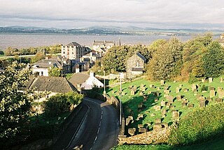
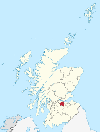
Borrowstounness is a town and former burgh and seaport on the south bank of the Firth of Forth in the Central Lowlands of Scotland. Historically part of the county of West Lothian, it is a place within the Falkirk council area, 17 miles northwest of Edinburgh and 6+34 miles east of Falkirk. At the 2011 United Kingdom census, the population of the Bo'ness locality was 15,100.

<span class="mw-page-title-main">Grangemouth</span> Town in Scotland

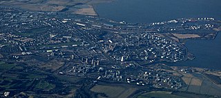
Grangemouth is a town in the Falkirk council area, Scotland. Historically part of the county of Stirlingshire, the town lies in the Forth Valley, on the banks of the Firth of Forth, 3 miles (4.8 km) east of Falkirk, 5 miles (8.0 km) west of Bo'ness and 13 miles (20.9 km) south-east of Stirling. Grangemouth had a resident population of 17,906 according to the 2001 Census. Preliminary figures from the 2011 census reported the number as 17,373.

<span class="mw-page-title-main">Pollokshaws</span> Human settlement in Scotland

Pollokshaws is an area on the South side of the city of Glasgow, Scotland. It is bordered by the residential neighbourhoods of Auldhouse to the east, Eastwood and Hillpark to the south and Shawlands to the north, with the Glasgow South Western Line railway and the open lands of Pollok Country Park to the west. The White Cart Water flows through the area.

<span class="mw-page-title-main">Linlithgow</span> Town in Scotland

Linlithgow is a town in West Lothian, Scotland. It was historically West Lothian's county town, reflected in the county's historical name of Linlithgowshire. An ancient town, it lies in the Central Belt on an historic route between Edinburgh and Falkirk beside Linlithgow Loch. The town is situated approximately 20 miles (32 km) west of Edinburgh.

<span class="mw-page-title-main">Carriden House</span> Historic site in Boness, Falkirk

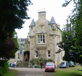
Carriden House is a 14,041 square feet (1,304.5 m2) mansion in the parish of Bo'ness and Carriden, in the Falkirk council area, east central Scotland. It is located on the Antonine Wall 2.5 kilometres (1.6 mi) east of Bo'ness, and 4 kilometres (2.5 mi) north-east of Linlithgow, in the former county of West Lothian. The earliest part of the house is an early 17th-century tower house, which was extended in the 17th and 19th centuries. Carriden House is protected as a category A listed building.

<span class="mw-page-title-main">Falkirk Public Library</span> Public library in Falkirk, Scotland, UK

Falkirk Public Library is a public library in Falkirk, Scotland. It is administered by Falkirk Community Trust.

<span class="mw-page-title-main">Barrhead Burgh Hall</span> Municipal Building in Barrhead, Scotland

Barrhead Burgh Hall, also known as Barrhead Burgh Court Hall and Burgh Chambers and as the James McGuire Building, is a municipal complex in Main Street, Barrhead, East Renfrewshire, Scotland. The complex was the headquarters of Barrhead Burgh Council. It consists of two distinct buildings separated by an iron gate: Barrhead Burgh Court Hall, which is a Category C listed building, and, Barrhead Burgh Chambers, which is also a Category C listed building, although, as a group, they are listed at Category B.

<span class="mw-page-title-main">Grangemouth Town Hall</span> Municipal building in Grangemouth, Scotland

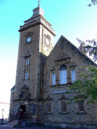
Grangemouth Town Hall is a municipal structure in Bo'ness Road, Grangemouth, Scotland. The structure was the meeting place of Grangemouth Burgh Council and remains the main events venue in the area.

Bo'ness RFC is a rugby union club based in Bo'ness, Scotland. The club has been through three known iterations with the third and most recent being founded in 2011. Their men's team currently plays in Caledonia Midlands Four.

<span class="mw-page-title-main">Stirling Tolbooth</span> Municipal building in Stirling, Scotland

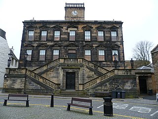
Stirling Tolbooth is a municipal building in Broad Street, Stirling, Scotland. The structure, which was the original meeting place of Stirling Burgh Council, is a Category A listed building.

<span class="mw-page-title-main">Wigtown County Buildings</span> Municipal building in Wigtown, Scotland

Wigtown County Buildings, also known as Wigtown County Buildings and Town Hall, is a municipal building in The Square, Wigtown, Scotland. The structure primarily served as the meeting place and town hall for Wigtown Burgh Council, but was also used for some meetings of Wigtownshire County Council. It is a Category B listed building.

<span class="mw-page-title-main">Linlithgow Burgh Halls</span> Municipal building in Linlithgow, Scotland

Linlithgow Burgh Halls is a municipal structure at The Cross, Linlithgow, Scotland. The complex includes the Town House, the former headquarters of Linlithgow Burgh Council, which is a Category A listed building. and the Old County Hall, the former headquarters of West Lothian County Council, which is a Category B listed building.

<span class="mw-page-title-main">Galashiels Burgh Chambers</span> Municipal building in Galashiels, Scotland

Galashiels Burgh Chambers is a municipal building in Albert Place, Galashiels, Scotland. The building, which was the headquarters of Galashiels Burgh Council, is a Category B listed building.

<span class="mw-page-title-main">Kinross Town Hall</span> Municipal building in Kinross, Scotland

Kinross Town Hall forms part of a complex of municipal buildings in the High Street, Kinross, Perth and Kinross, Scotland. The town hall, which has been converted for residential use, is a Category B listed building.

<span class="mw-page-title-main">New Galloway Town Hall</span> Historic municipal building in Scotland

The New Galloway Town Hall is a municipal building in Dumfries and Galloway, Scotland, situated on the town's high street. A tolbooth has existed on the site of the current building since at least 1711; in 1875, it was rebuilt and enlarged. In 1971 it was designated a Category B listed building.

<span class="mw-page-title-main">Lochmaben Town Hall</span> Municipal building in Lochmaben, Scotland

Lochmaben Town Hall is a municipal building in the High Street in Lochmaben, Dumfries and Galloway, Scotland. The structure, which accommodates a library and a local customer services point, is a Category A listed building.

References

  1. 1 2 Historic Environment Scotland. "Stewart Avenue, Town Hall and former Carnegie Library including boundary walls and gatepiers (LB22397)" . Retrieved 22 July 2021.
  2. "Bo'ness, North Street, Town Hall And Clock Tower". Camore. Retrieved 22 July 2021.
  3. Lewis, Samuel (1846). "'Berwick-upon-Tweed - Braidwood', in A Topographical Dictionary of Scotland". London: British History Online. pp. 124–151. Retrieved 22 July 2021.
  4. Salmon, Thomas James (1913). "Borrowstounness and District Being Historical Sketches of Kinneil, Carriden, and Bo'ness c.1550-1850". Scottish Mining. Retrieved 22 July 2021.
  5. Gillen, Con (2003). Geology and Landscapes of Scotland. Terra Publishing. ISBN   978-1903544099.
  6. 1 2 "Bo'ness Town Council". Falkirk Archives. Retrieved 22 July 2021.
  7. "Ordnance Survey Map". 1897. Retrieved 22 July 2021.
  8. "Bo'ness Old Parish Church records". Falkirk Archives. Retrieved 22 July 2021.
  9. Guppy, Henry; Esdaile, Arundell (1904). Library Association Record. Vol. 4. Library Association.
  10. Souvenir Programme Opening of Bo'ness Town Hall and Carnegie Library. Bo'ness Burgh Council. 14 September 1904.
  11. "Town Hall and Public Library". Dictionary of Scottish Architects. Retrieved 22 July 2021.
  12. Young, Alex F. (2009). Old Bo'ness. Catrine, Ayrshire: Stenlake Publishing. p. 41. ISBN   978-1840334821.
  13. "Queen Elizabeth and Duke of Edinburgh visit to Grangemouth" . Retrieved 22 July 2021. Note the distinctive Diocletian windows in the photograph
  14. "Local Government (Scotland) Act 1973". Legislation.gov.uk. Retrieved 16 April 2020.
  15. "Bo'ness Library". Falkirk Council. Retrieved 26 April 2021.
  16. Historic Environment Scotland. "Scotland's Close, Bo'ness Public Library, former old West Pier Tavern (LB22388)" . Retrieved 22 July 2021.
  17. "Bo'ness Town Hall". Ivvy Event Management. Retrieved 22 July 2021.