
A natural disaster is "the negative impact following an actual occurrence of natural hazard in the event that it significantly harms a community". A natural disaster can cause loss of life or damage property, and typically leaves some economic damage in its wake. The severity of the damage depends on the affected population's resilience and on the infrastructure available. Examples of natural hazards include: avalanche, coastal flooding, cold wave, drought, earthquake, hail, heat wave, hurricane, ice storm, landslide, lightning, riverine flooding, strong wind, tornado, tsunami, volcanic activity, wildfire, winter weather.
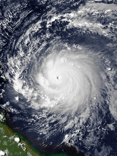
Hurricane Hugo was a powerful Cape Verde tropical cyclone that inflicted widespread damage across the northeastern Caribbean and the Southeastern United States in September 1989. Across its track, Hugo affected approximately 2 million people. Its direct effects killed 67 people and inflicted $11 billion in damage. The damage wrought by the storm was more costly than any Atlantic hurricane preceding it. At its peak strength east of the Lesser Antilles, Hugo was classified as a Category 5 hurricane—the highest rating on the Saffir–Simpson scale. Over the course of five days, Hugo made landfalls on Guadeloupe, Saint Croix, Puerto Rico, and South Carolina, bringing major hurricane conditions to these and surrounding areas. Lesser effects were felt along the periphery of the hurricane's path in the Lesser Antilles and across the Eastern United States into Eastern Canada. The scale of Hugo's impacts led to the retirement of the name Hugo from Atlantic hurricane names.
The 1900 Galveston hurricane, also known as the Great Galveston hurricane and the Galveston Flood, and known regionally as the Great Storm of 1900 or the 1900 Storm, was the deadliest natural disaster in United States history and the fifth-deadliest Atlantic hurricane, only behind Hurricane Mitch overall. The hurricane left between 6,000 and 12,000 fatalities in the United States; the number most cited in official reports is 8,000. Most of these deaths occurred in and near Galveston, Texas, after the storm surge inundated the coastline with 8 to 12 ft of water. In addition to the number killed, the storm destroyed about 7,000 buildings of all uses in Galveston, which included 3,636 demolished homes; every dwelling in the city suffered some degree of damage. The hurricane left approximately 10,000 people in the city homeless, out of a total population of fewer than 38,000. The disaster ended the Golden Era of Galveston, as the hurricane alarmed potential investors, who turned to Houston instead. In response to the storm, three engineers designed and oversaw plans to raise the Gulf of Mexico shoreline of Galveston Island by 17 ft (5.2 m) and erect a 10 mi (16 km) seawall.

Hurricane Donna, known in Puerto Rico as Hurricane San Lorenzo, was the strongest hurricane of the 1960 Atlantic hurricane season, and caused severe damage to the Lesser Antilles, the Greater Antilles, and the East Coast of the United States, especially Florida, in August–September. The fifth tropical cyclone, third hurricane, and first major hurricane of the season, Donna developed south of Cape Verde on August 29, spawned by a tropical wave to which 63 deaths from a plane crash in Senegal were attributed. The depression strengthened into Tropical Storm Donna by the following day. Donna moved west-northwestward at roughly 20 mph (32 km/h) and by September 1, it reached hurricane status. Over the next three days, Donna deepened significantly and reached maximum sustained winds of 130 mph (210 km/h) on September 4. Thereafter, it maintained intensity as it struck the Lesser Antilles later that day. On Sint Maarten, the storm left a quarter of the island's population homeless and killed seven people. An additional five deaths were reported in Anguilla, and there were seven other fatalities throughout the Virgin Islands. In Puerto Rico, severe flash flooding led to 107 fatalities, 85 of them in Humacao alone.
Hurricane Elena was an unpredictable and damaging tropical cyclone that affected eastern and central portions of the United States Gulf Coast in late August and early September 1985. Threatening popular tourist destinations during Labor Day weekend, Elena repeatedly deviated from its forecast path, triggering evacuations of unprecedented extent. The hurricane wrought havoc to property and the environment between southwestern Florida and eastern Louisiana, though lesser effects were felt well beyond those areas. Elena developed on August 28 near Cuba, and after traveling lengthwise across the island with little impact, it entered the Gulf of Mexico and continued to strengthen. Initially projected to strike the central Gulf Coast, the hurricane unexpectedly veered toward the east on August 30, then stalled just 50 mi (80 km) west of Cedar Key, Florida. Despite predictions that Elena would continue eastward across Florida, the cyclone remained nearly stationary for about 48 hours, causing damage all along the eastern gulf with high winds and waves, before slowly moving northwest and ultimately making landfall near Biloxi, Mississippi, on September 2 as a Category 3 major hurricane. The storm quickly weakened upon moving ashore and dissipated on September 4.

Hurricane Eloise was the most destructive tropical cyclone of the 1975 Atlantic hurricane season. The fifth tropical storm, fourth hurricane, and second major hurricane of the season, Eloise formed as a tropical depression on September 13 to the east of the Virgin Islands. The depression tracked westward and intensified into a tropical storm while passing to the north of Puerto Rico. Eloise briefly attained hurricane intensity soon thereafter, but weakened back to a tropical storm upon making landfall over Hispaniola. A weak and disorganized cyclone, Eloise emerged into open waters of the northern Caribbean Sea; upon striking the northern Yucatan Peninsula, it turned north and began to re-intensify. In the Gulf of Mexico, the cyclone quickly matured and became a Category 3 hurricane on September 23. Eloise made landfall along the Florida Panhandle west of Panama City before moving inland across Alabama and dissipating on September 24.
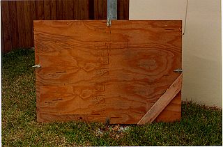
Hurricane coverings, commonly known as shutters, are used in hurricane mitigation to protect houses and other structures from damage caused by storms. Hurricane shutters are used to prevent windows from being broken by flying objects during a storm. Although the negative pressure caused by high velocity wind flowing over a building roof can cause the roof to fail with the building envelope intact, broken windows allow the air pressure to rise inside a building, creating an even greater pressure difference, and increasing the likelihood of roof failure.

The 1933 Atlantic hurricane season set the record for the most named or nameable storms formed within a single season, 20, which stood until the 2005 season, during which there were 28 storms. It also produced the highest Accumulated Cyclone Energy (ACE) on record in the Atlantic basin, with a total of 259. The season ran through the summer and the first half of fall in 1933, with activity as early as May and as late as November. A tropical cyclone was active for all but 13 days from June 28 to October 7.

The Great Miami Hurricane of 1926 was a large and intense tropical cyclone that devastated the Greater Miami area and caused catastrophic damage in the Bahamas and the U.S. Gulf Coast in September of the year 1926, accruing a US$100 million damage toll. As a result of the devastation wrought by the hurricane in Florida, the Land Boom in Florida ended. The hurricane represented an early start to the Great Depression in the aftermath of the state's 1920s land boom. It has been estimated that a similar hurricane would cause about $235 billion in damage if it were to hit Miami in 2018.

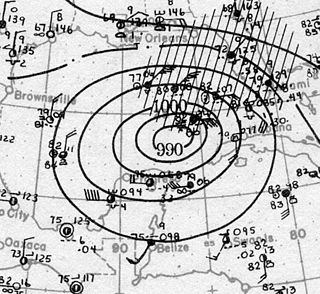
The Okeechobee hurricane of 1928, also known as the San Felipe Segundo hurricane, was one of the deadliest hurricanes in the recorded history of the North Atlantic basin, and the third deadliest hurricane in the United States, only behind the 1900 Galveston hurricane and Hurricane Maria. The hurricane killed an estimated 2,500 people in the United States; most of the fatalities occurred in the state of Florida, particularly in Lake Okeechobee. It was the fourth tropical cyclone, third hurricane, and only major hurricane of the 1928 Atlantic hurricane season. It developed off the west coast of Africa on September 6 as a tropical depression, but it strengthened into a tropical storm later that day, shortly before passing south of the Cape Verde islands. Further intensification was slow and halted late on September 7. About 48 hours later, the storm strengthened and became a Category 1 hurricane on the Saffir–Simpson hurricane wind scale. Still moving westward, the system reached Category 4 intensity before striking Guadeloupe on September 12, where it brought great destruction and resulted in 1,200 deaths. The islands of Martinique, Montserrat, and Nevis also reported damage and fatalities, but not nearly as severe as in Guadeloupe.

As the center of Hurricane Katrina passed southeast of New Orleans on August 29, 2005, winds downtown were in the Category 1 range with frequent intense gusts. The storm surge caused approximately 23 breaches in the drainage canal and navigational canal levees and flood walls. As mandated in the Flood Control Act of 1965, responsibility for the design and construction of the city's levees belongs to the United States Army Corps of Engineers and responsibility for their maintenance belongs to the Orleans Levee Board. The failures of levees and flood walls during Katrina are considered by experts to be the worst engineering disaster in the history of the United States. By August 31, 2005, 80% of New Orleans was flooded, with some parts under 15 feet (4.6 m) of water. The famous French Quarter and Garden District escaped flooding because those areas are above sea level. The major breaches included the 17th Street Canal levee, the Industrial Canal levee, and the London Avenue Canal flood wall. These breaches caused the majority of the flooding, according to a June 2007 report by the American Society of Civil Engineers. The flood disaster halted oil production and refining which increased oil prices worldwide.

Cyclone mitigation encompasses the actions and planning taken before a tropical cyclone strikes to mitigate damage and injury from the storm. Knowledge of tropical cyclone impacts on an area help plan for future possibilities. Preparedness may involve preparations made by individuals as well as centralized efforts by governments or other organizations. Tracking storms during the tropical cyclone season helps individuals know current threats. Regional Specialized Meteorological Centers and Tropical Cyclone Warning Centers provide current information and forecasts to help individuals make the best decision possible.

Typhoon Karen was the most powerful tropical cyclone to strike the island of Guam, and has been regarded as one of the most destructive events in the island's history. It was first identified as a tropical disturbance on November 6, 1962, well to the southeast of Truk. Over the following two days, the system tracked generally northward and quickly intensified. Karen became a tropical storm late on November 7, and within two days it explosively intensified into a Category 5-equivalent super typhoon on the Saffir–Simpson scale. Turning westward, the typhoon maintained its intensity and struck Guam with winds of 280 km/h (175 mph) on November 11. Once clear of the island, it strengthened slightly and reached its peak intensity on November 13 with winds of 295 km/h (185 mph) and a barometric pressure of 894 mb. The storm then gradually turned northward as it weakened, brushing the Ryukyu Islands on November 15, before moving east-northeastward over the open waters of the Pacific. Karen continued to weaken and transitioned into an extratropical cyclone on November 17 before losing its identity the following day between Alaska and Hawaii.
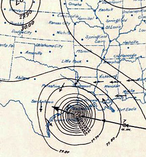
The Tampa Bay hurricane of 1921 was the most recent major hurricane to strike the Tampa Bay Area and the second latest major hurricane to strike the continental United States in the calendar year on record, behind Hurricane Zeta in 2020. The eleventh tropical cyclone, sixth tropical storm, and fifth hurricane of the season, the storm developed from a trough in the southwestern Caribbean Sea on October 20. Initially a tropical storm, the system moved northwestward and intensified into a hurricane on October 22 and a major hurricane by October 23. Later that day, the hurricane peaked as a Category 4 on the modern day Saffir–Simpson scale with maximum sustained winds of 140 mph (220 km/h). After entering the Gulf of Mexico, the hurricane gradually curved northeastward and weakened to a Category 3 before making landfall near Tarpon Springs, Florida, late on October 25, becoming the first major hurricane to hit the area since a hurricane in 1848. The storm quickly weakened to a Category 1 hurricane while crossing Central Florida, before reaching the Atlantic Ocean early on the following day. Thereafter, system moved east-southeastward and remained fairly steady in intensity before weakening to a tropical storm late on October 29. The storm was then absorbed by a larger extratropical cyclone early the next day, with the remnants of the hurricane soon becoming indistinguishable.

The 1949 Florida hurricane, also known as the Delray Beach hurricane, caused significant damage in the southern portions of the state late in the month of August. The second recorded tropical cyclone of the annual hurricane season, the system originated from a tropical wave near the northern Leeward Islands on August 23. Already a tropical storm upon initial observations, the cyclone curved west-northwestward and intensified, becoming a hurricane on August 25. Rapid intensification ensued as the storm approached the central Bahamas early on August 26, with the storm reaching Category 4 hurricane strength later that day and peaking with maximum sustained winds of 130 mph (215 km/h) shortly after striking Andros. Late on August 26, the storm made landfall near Lake Worth, Florida, at the same intensity. The cyclone initially weakened quickly after moving inland, falling to Category 1 status early the next day. Shortly thereafter, the system curved northward over the Nature Coast and entered Georgia on August 28, where it weakened to a tropical storm. The storm then accelerated northeastward and became extratropical over New England by August 29. The remnants traversed Atlantic Canada and much of the Atlantic Ocean before dissipating near Ireland on September 1.
The 1941 Florida hurricane was a compact but strong tropical cyclone that affected the Bahamas, Florida, and the southeastern United States in October 1941. The fifth known storm of the 1941 Atlantic hurricane season, it was first observed to the north of the Virgin Islands on October 3. The storm tracked generally westward, reaching peak winds of 120 miles per hour (193 km/h) before passing through the Bahamas. After weakening somewhat, the storm later passed across southern Florida with winds of 100 mph (161 km/h). The hurricane then emerged into the Gulf of Mexico as a tropical storm, but regained hurricane intensity and made another landfall along the Florida Panhandle. Turning northeast, it crossed Georgia and South Carolina, and entered the Atlantic Ocean on October 8.
Tornadoes, cyclones, and other storms with strong winds damage or destroy many buildings. However, with proper design and construction, the damage to buildings by these forces can be greatly reduced. A variety of methods can help a building survive strong winds and storm surge.

Hurricane Andrew was a very powerful and destructive Category 5 Atlantic hurricane that struck the Bahamas, Florida, and Louisiana in August 1992. It is the most destructive hurricane to ever hit Florida in terms of structures damaged or destroyed, and was the costliest in financial terms until Hurricane Irma surpassed it 25 years later. It was the strongest landfalling hurricane in decades and the costliest hurricane to make landfall anywhere in the United States, until it was surpassed by Katrina in 2005. In addition, Andrew is one of only four hurricanes to make landfall in the United States as a Category 5, alongside the 1935 Labor Day hurricane, 1969's Camille and 2018's Michael. Andrew caused major damage in the Bahamas and Louisiana, but the greatest impact was felt in South Florida, where the storm made landfall as a Category 5 hurricane, with 1-minute sustained wind speeds as high as 165 mph (280 km/h) and a gust as high as 174 mph (280 km/h). Passing directly through the city of Homestead in Dade County, Andrew stripped many homes of all but their concrete foundations. In total, Andrew destroyed more than 63,500 houses, damaged more than 124,000 others, caused $27.3 billion in damage, and left 65 people dead.
The 1926 Havana hurricane devastated large areas of Cuba and Bermuda in October 1926. The tenth tropical cyclone, eighth hurricane, and sixth major hurricane of the annual hurricane season, the storm formed from a low-pressure area in the southern Caribbean Sea on October 14. Moving slowly to the north, it steadily intensified, attaining hurricane intensity on October 18 near the Swan Islands. After passing the islands, the hurricane began to rapidly intensify as it accelerated to the north, attaining major hurricane intensity the following day. The storm later made two landfalls on Cuba as it reached peak intensity with winds of 150 mph (240 km/h) and a minimum central pressure of 934 mbar. The hurricane slightly weakened as it passed over the island, and after entering the Straits of Florida, made a close pass of southern Florida and The Bahamas. Afterwards, the storm gradually weakened, passing over Bermuda on October 22, before executing a clockwise loop and dissipating on October 28, after becoming absorbed by an extratropical cyclone.
The effects of the 1928 Okeechobee hurricane in Florida included at least 2,500 fatalities in the state, making this the second deadliest tropical cyclone on record in the contiguous United States, behind only the 1900 Galveston hurricane. The storm originated from a tropical depression that developed near Dakar, Senegal, on September 6. Traversing the Atlantic Ocean, the cyclone struck the Lesser Antilles, Puerto Rico, and the Bahamas as a powerful hurricane. Early on September 17, the storm made landfall near Palm Beach, Florida, as a Category 4 hurricane on the modern-day Saffir–Simpson hurricane wind scale. After initially moving northwestward across Florida, the cyclone curved north-northeastward near the Tampa Bay area. The hurricane briefly re-emerged into the Atlantic prior to striking South Carolina on September 18 and becoming extratropical over North Carolina on the next day, before the remnants lost their identity over Ontario on September 21.
