
The Boca de Quadra is a bay extending southwest from the Keta River to Revillagigedo Channel in Southeastern Alaska. [1] It is located almost entirely within Misty Fjords National Monument.
The Boca de Quadra is a bay extending southwest from the Keta River to Revillagigedo Channel in Southeastern Alaska. [1] It is located almost entirely within Misty Fjords National Monument.
The bay was named in 1792 for Juan Francisco de Bodega y Quadra by Jacinto Caamano, in relation to Quadra's expeditions and surveys in the region in 1775–79. The name was adopted by Captain George Vancouver, RN who explored this estuary on August 6, 1793. [2]
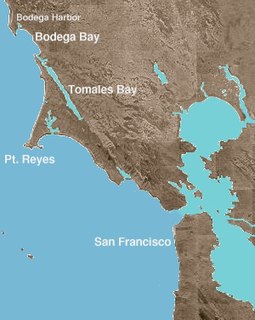
Bodega Bay is a shallow, rocky inlet of the Pacific Ocean on the coast of northern California in the United States. It is approximately 5 mi (8 km) across and is located approximately 40 mi (60 km) northwest of San Francisco and 20 mi (32 km) west of Santa Rosa. The bay straddles the boundary between Sonoma County to the north and Marin County to the south. The bay is a marine habitat used for navigation, recreation, and commercial and sport fishing.
Chatham Strait, or Shee ya xhaak in the Tlingit language, is a narrow passage of the Alexander Archipelago in the southeastern region of the U.S. state of Alaska. It separates Chichagof Island and Baranof Island to its west from Admiralty Island and Kuiu Island on its east.

Juan Francisco de la Bodega y Quadra was a Spanish Criollo naval officer operating in the Americas. Assigned to the Pacific coast Spanish Naval Department base at San Blas, in the Viceroyalty of New Spain, this navigator explored the Northwest Coast of North America as far north as present day Alaska.

Matanzas Inlet is a channel in Florida between two barrier islands and the mainland, connecting the Atlantic Ocean and the south end of the Matanzas River. It is 14 miles (23 km) south of St. Augustine, in the southern part of St. Johns County. The inlet is not stabilized by jetties, and thus is subject to shifting.
Suemez Island is located in the Alexander Archipelago of southeastern Alaska, United States. It resides in the west-central coast of Prince of Wales Island. The northern tip of Dall Island lies to its southeast, while Baker Island lies to its northwest. Suemez Island has a land area of 151.713 km2 and was unpopulated at the 2000 census.
During the Age of Exploration, the Spanish Empire undertook several expeditions to the Pacific Northwest of North America. Spanish claims to the region date to the papal bull of 1493, and the Treaty of Tordesillas signed in 1494. In 1513, this claim was reinforced by Spanish explorer Vasco Núñez de Balboa, the first European to sight the Pacific Ocean, when he claimed all lands adjoining this ocean for the Spanish Crown. Spain only started to colonize the claimed territory north of present-day Mexico in the 18th century, when it settled the northern coast of Las Californias.
New Somerset is an unincorporated community in northern Knox Township, Jefferson County, Ohio, United States. It lies south of Hammondsville along State Route 213, at 40°30′57″N80°42′21″W.
Old Milan is an unincorporated community in Franklin Township, Ripley County, in the U.S. state of Indiana.
Juan Carrasco was a Spanish naval officer, explorer, and navigator. He is remembered mainly for his work in the Pacific Northwest during the late 18th century. He was second in command of the 1791 voyage of José María Narváez, the first European exploration of the Strait of Georgia.
Bucareli Bay is a bay in the Alexander Archipelago, in the southeastern part of the U.S. state of Alaska. It is located off the western coast of Prince of Wales Island, between Baker Island and Suemez Island. To the east it connects to various waterways, such as San Alberto Bay. To the west it opens directly upon the Pacific Ocean. Bucareli Bay is about 25 miles (40 km) long.
Cape Fox Village is a locality in Southeast Alaska near present-day Ketchikan. It is the site of a former village called Gaash of the Cape Fox people of the Tlingit. The location of the village is on the east side of Revillagigedo Channel, four miles south of Boca de Quadra. The name was recorded in 1880 by Ivan Petroff during the 10th Census, who reported 100 Tlingit still living there. During the Harriman Expedition of Alaska that took place in 1899 several native artifacts that were important to the neighboring populations of Cape Fox were removed and relocated to several academic institutions across the United States, including the Field Museum in Chicago, and Cornell University. The expedition saw the artifacts as inanimate objects from a deserted village. To the Tlingit living nearby, the artifacts were a sacred part of their identity. This event is referred as the "Looting of Cape Fox." Since the looting, several artifacts have been returned to Tlingit communities near Cape Fox in an effort to return stolen artifacts to the ancestors of who created them.
Ignacio de Arteaga y Bazán was an officer of the Spanish Navy.
Port Etches is a bay in the southcentral part of the U.S. state of Alaska. It is located on the west side of Hinchinbrook Island and opens onto Hinchinbrook Entrance, a strait between Hinchinbrook Island and Montague Island, connecting Prince William Sound and the Gulf of Alaska.

Valle de Valdelaguna is a town in the province of Burgos, Autonomous Community of Castilla y León (Spain), region of the Complaint, the judicial district of Salas de los Infantes. Its capital is the town of Huerta de Abajo.
The Keta River is a river in Southeastern Alaska in the United States, flowing generally south-southwest to enter the Boca de Quadra, which connects to the sea via Revillagigedo Channel about 45 miles (72 km) east of Ketchikan. It is located almost entirely within Misty Fjords National Monument.
Emerickville is an unincorporated community in Jefferson County, in the U.S. state of Pennsylvania.

Walnut Corners is an unincorporated community in Columbia Township, Whitley County, in the U.S. state of Indiana.
Sni Mills is an unincorporated community in Jackson County, in the U.S. state of Missouri.
Reading is an extinct town in Pike County, in the U.S. state of Missouri. The GNIS classifies it as a populated place.
Bunker Hill is an unincorporated community in Stoddard County, in the U.S. state of Missouri.
| General | |
|---|---|
| National libraries | |
Coordinates: 55°07′57″N130°42′21″W / 55.13250°N 130.70583°W
| | This article about a location in the Ketchikan Gateway Borough, Alaska is a stub. You can help Wikipedia by expanding it. |