
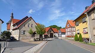
Dingelstädt is a town in the district of Eichsfeld in Thuringia, Germany. It is situated on the upper course of the river Unstrut, 8 km (5 mi) south of Leinefelde-Worbis and 15 km (9 mi) northwest of Mühlhausen. The former municipalities Helmsdorf, Kefferhausen, Kreuzebra and Silberhausen were merged into Dingelstädt in January 2019. In January 2023 Dingelstädt absorbed the villages Bickenriede and Zella from the former municipality Anrode, and Beberstedt and Hüpstedt from the former municipality Dünwald. In January 2024 it absorbed the village Struth from the former municipality Rodeberg.
Jützenbach is a village and a former municipality in the district of Eichsfeld in Thuringia, Germany. Since 1 December 2011, it is part of the municipality Sonnenstein, of which it is an Ortschaft.
Holungen is a village and a former municipality in the district of Eichsfeld in Thuringia, Germany. Since 1 December 2011, it is part of the municipality Sonnenstein, of which it is an Ortschaft. It lies approximately 35 km (22 mi) from the university town of Göttingen. With a population of around 1,000, it is one of the medium-sized villages in the district.
Silkerode is a village and a former municipality in the district of Eichsfeld in Thuringia, Germany. Since 1 December 2011, it is part of the municipality Sonnenstein, of which it is an Ortschaft.
Steinrode is a former municipality in the district of Eichsfeld in Thuringia, Germany. Since 1 December 2011, it is part of the municipality Sonnenstein, of which it is an Ortschaft. The Ortschaft Steinrode consists of the villages Werningerode and Epschenrode.

Stöckey is a village and a former municipality in the district of Eichsfeld in Thuringia, Germany. Since 1 December 2011, it is part of the municipality Sonnenstein, of which it is an Ortschaft.
Weißenborn-Lüderode is a village and a former municipality in the district of Eichsfeld in Thuringia, Germany. Since 1 December 2011, it is part of the municipality Sonnenstein, of which it is an Ortschaft and the seat.
Zwinge is a village and a former municipality in the district of Eichsfeld in Thuringia, Germany. Since 1 December 2011, it is part of the municipality Sonnenstein, of which it is an Ortschaft.
Gernrode is a municipality in the district of Eichsfeld in Thuringia, Germany. Its agricultural land is some of the most productive in the district and it therefore does not have any wooded areas.
Glasehausen is a village and a former municipality in the district of Eichsfeld in Thuringia, Germany. On 1 January 2024 it became part of the town Heilbad Heiligenstadt.
Lutter is a village and a former municipality in the district of Eichsfeld in Thuringia, Germany. On 1 January 2024 it became part of the municipality Uder.
Mackenrode is a village and a former municipality in the district of Eichsfeld in Thuringia, Germany. On 1 January 2024 it became part of the municipality Uder.
Röhrig is a village and a former municipality in the district of Eichsfeld in Thuringia, Germany. On 1 January 2024 it became part of the municipality Uder.
Steinheuterode is a village and a former municipality in the district of Eichsfeld in Thuringia, in the center of Germany. On 1 January 2024 it became part of the municipality Uder.
Thalwenden is a village and a former municipality in the district of Eichsfeld in Thuringia, Germany. On 1 January 2024 it became part of the municipality Uder.
Wüstheuterode is a village and a former municipality in the district of Eichsfeld in Thuringia, Germany. On 1 January 2024 it became part of the municipality Uder.
Eichsfeld-Südharz was a Verwaltungsgemeinschaft in the district Eichsfeld, in Thuringia, Germany. The seat of the Verwaltungsgemeinschaft was in Weißenborn-Lüderode. The Verwaltungsgemeinschaft was disbanded on 1 December 2011, when its constituent municipalities merged into the new municipality Sonnenstein.

Sonnenstein is a municipality in the district of Eichsfeld, Thuringia, Germany. It was formed by the merger of the previously independent municipalities Bockelnhagen, Holungen, Jützenbach, Silkerode, Steinrode, Stöckey, Weißenborn-Lüderode and Zwinge, on 1 December 2011. These municipalities had previously been part of the Verwaltungsgemeinschaft Eichsfeld-Südharz, which was disbanded. The seat of the municipality is in the village Weißenborn-Lüderode. The municipality consists of 8 Ortschaften : Bockelnhagen, Holungen, Jützenbach, Silkerode, Steinrode, Stöckey, Weißenborn-Lüderode and Zwinge.

The Ohm Hills are a small range of hills up to 533.4 m above sea level (NN) high and about 50 km² in area. They are part of the Lower Eichsfeld region and are located in the county of Eichsfeld, North Thuringia, Germany.
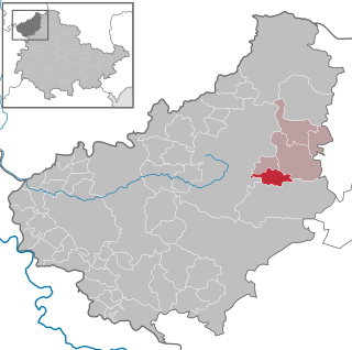
Eichsfeld II is an electoral constituency represented in the Landtag of Thuringia. It elects one member via first-past-the-post voting. Under the current constituency numbering system, it is designated as constituency 2. It comprises the eastern part of the district of Eichsfeld.


