
The Harz is a highland area in northern Germany. It has the highest elevations for that region, and its rugged terrain extends across parts of Lower Saxony, Saxony-Anhalt, and Thuringia. The name Harz derives from the Middle High German word Hardt or Hart, Latinized as Hercynia. The Brocken is the highest summit in the Harz with an elevation of 1,141.1 metres (3,744 ft) above sea level. The Wurmberg is the highest peak located entirely within the state of Lower Saxony.
Harz National Park is a nature reserve in the German federal states of Lower Saxony and Saxony-Anhalt. It comprises portions of the western Harz mountain range, extending from Herzberg and Bad Lauterberg at the southern edge to Bad Harzburg and Ilsenburg on the northern slopes. 95 % of the area is covered with forests, mainly with spruce and beech woods, including several bogs, granite rocks and creeks. The park is part of the Natura 2000 network of the European Union.
Whistler Blackcomb is a ski resort located in Whistler, British Columbia, Canada. By many measures it is the largest ski resort in North America and has the greatest uphill lift capacity. It features the Peak 2 Peak Gondola for moving between Whistler and Blackcomb mountains at the top. With all of this capacity, Whistler Blackcomb is also often the busiest ski resort, often surpassing 2 million visitors a year.
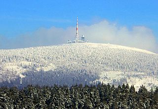
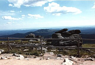
The Brocken, also sometimes referred to as the Blocksberg, is the highest peak of the Harz mountain range and also the highest peak of Northern Germany; it is located near Schierke in the German state of Saxony-Anhalt between the rivers Weser and Elbe. Although its elevation of 1,141 metres (3,743 ft) is below alpine dimensions, its microclimate resembles that of mountains of about 2,000 m (6,600 ft). The peak above the tree line tends to have a snow cover from September to May, and mists and fogs shroud it up to 300 days of the year. The mean annual temperature is only 2.9 °C (37.2 °F). It is the easternmost mountain in northern Germany; travelling east in a straight line, the next prominent elevation would be in the Ural Mountains in Russia.

Braunlage is a town and health resort in the Goslar district in Lower Saxony in Germany. Situated within the Harz mountain range, south of the Brocken massif, Braunlage's main business is tourism, particularly skiing. Nearby ski resorts include the Sonnenberg and the slopes on the Wurmberg.
SilverStar Mountain Resort (SilverStar) is a ski resort located near Silver Star Provincial Park in the Shuswap Highland of the Monashee Mountains, 22 km northeast of the city of Vernon, British Columbia, Canada. SilverStar's snow season runs from late November to mid-April weather permitting. SilverStar provides summer lift access for mountain biking and hiking from the end of June through to September.

The Wurmberg Gondola Lift is a monocable gondola lift with a length of 1.7 miles (2.7 km), built in 1963, leading from the Braunlage tourist resort within the Harz mountain range on the top of the 3,185 feet (971 m) high Wurmberg mountain.

The Bode Valley Gondola Lift is a gondola lift built between 1969 and 1970 by the Czechoslovak collective combine Transporta Chrudim as a joint project with PGH Elektrotherm Quedlinburg in the vicinity of Thale in the Harz mountains in Lower Saxony, Germany. It runs from its valley station at a height of 183 metres (600 ft) above sea level to the top station on the plateau of Hexentanzplatz, which is 428 metres (1,404 ft) high. The 721 metres (788 yd) long, twin cable, gondola lift has inclines of up to 75 per cent in places. It has a total of 3 pylons, the lowest in the Bode valley having a height of 45 metres (148 ft). The other two pylons are designed for the gondola cabins to run over the top of them because of the steep inclines. The lift has 38 small cabins or 'gondolas', each with a capacity of 6 persons. The Bode Valley Gondola Lift operates all-year round. The cost is €3 for adults one-way.

Schierke is a village and a former municipality in the Harz district, in the German state of Saxony-Anhalt. Since 1 July 2009, it is part of the town Wernigerode. Situated within the Harz mountain range in the valley of the Bode River, at the rim of the Harz National Park, it is mainly a tourist resort, especially for hiking and all kinds of winter sports.
Hahnenklee is a borough of the city of Goslar, in the German state of the Lower Saxony. It is located within the Harz mountain range between Goslar and Osterode.

At 971 m above sea level (NN) the Wurmberg is the second highest mountain in the Harz and the highest in Lower Saxony (Germany).
At 927 m above sea level (NN), the Bruchberg in the Upper Harz is the second highest mountain in Lower Saxony and the third highest in the Harz mountains in North Germany. It lies between Altenau and Torfhaus in the middle of the Harz National Park. The Bruchberg is more like a plateau and has no real summit. This plateau is partly covered with trees, but on the sunny southern slopes the trees have largely died as a result of bark beetle infestation. Following this insect destruction, a new natural forest, rich in its variety of species, is now growing in the heart of the Harz National Park.

The Ravensberg is a 659 m high mountain in the South Harz mountains in the German state of Lower Saxony. It is relatively isolated and visible for a long way. It lies in the district of Göttingen, north of Bad Sachsa.

The Stöberhai is a mountain the Harz highlands in Central Germany, immediately south of the Oder Dam and northwest of Wieda. At a height of 720 m above sea level (NN) it is the highest mountain in the South Harz. The origin of the name is uncertain, but it is suggested, that a charcoal burner called Stöber may have had his charcoal store (Hai) here.

The Köterberg, at 495.8 m (1,627 ft) above sea level, is the highest hill in the Lippe Uplands and lies on the state border between North Rhine-Westphalia and Lower Saxony in North Germany. On its northern slopes is the village of Köterberg.

The Upper Harz refers to the northwestern and higher part of the Harz mountain range in Germany. The exact boundaries of this geographical region may be defined differently depending on the context. In its traditional sense, the term Upper Harz covers the area of the seven historical mining towns (Bergstädte) - Clausthal, Zellerfeld, Andreasberg, Altenau, Lautenthal, Wildemann and Grund - in the present-day German federal state of Lower Saxony. Orographically, it comprises the Harz catchment areas of the Söse, Innerste and Grane, Oker and Abzucht mountain streams, all part of the larger Weser watershed.

The Scharfenstein is a mountain, 697.6 m above sea level (NN) high, in the Harz Mountains of Germany, near Ilsenburg in the district of Harz in Saxony-Anhalt. It is part of the Harz National Park.

The Großer Winterberg is a mountain, 906.4 m above sea level (NN), and a subpeak of the Wurmberg, the highest mountain in the neighbouring state of Lower Saxony in the High Harz of central Germany. The Großer Winterberg rises within the borough of Wernigerode in the county of Harz in the state of Saxony-Anhalt.

The Kleiner Winterberg is a mountain, 837 m above sea level (NN), in the borough of Wernigerode, Harz county, in the German state of Saxony-Anhalt. It is found in the Harz Mountains and is a subpeak of the Wurmberg, the highest point in the neighbouring state of Lower Saxony.

